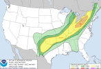
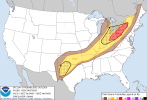
I still find it hard to trust the CAMS on this one - model guidance agrees the forcing will be impressive. The nose of the 300mb jet is placed nearly ideally relative to the warm sector on Monday afternoon/evening. Considering this will be fast moving, I just really don't see how we don't get at least 1-2 powerful tornadic storms in either IA, MN or WI.
View attachment 40452
Often, models may underestimate surface backing with deepening low pressures like the one tomorrow, and so I wouldn't be surprised for the dryline and any prefrontal confluences to be even slightly more convergent than expected.
Models also struggle to initiate convection in drier mid-level environments (Think 3/14, where a fair few number of CAMS were failing to initiate convection into AR just hours before the event, let alone the day before). I think a NAM or FV3 solution is closer to reality where get at least a few storms.
If the CAMS remain adamant all the way up to tomorrow then we may be able to breathe a sigh of relief regarding any tornado risk - but I still pretty uneasy about the whole setup and believe a higher end scenario is most certainly still on the table.