Tempestas Tonitrua
Member
Trey’s video (4/27 discussion starts around 15 minutes in). Notes the more amplitude shape of the trough and the walk back by the models from the more potent solutions shown previously.
Follow along with the video below to see how to install our site as a web app on your home screen.
Note: This feature may not be available in some browsers.
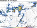
DAY 2 CONVECTIVE OUTLOOK
NWS STORM PREDICTION CENTER NORMAN OK
1230 PM CDT FRI APR 26 2024
VALID 271200Z - 281200Z
...THERE IS AN ENHANCED RISK OF SEVERE THUNDERSTORMS ACROSS PARTS OF
THE SOUTHERN/CENTRAL PLAINS...
..SUMMARY
NUMEROUS SEVERE THUNDERSTORMS ARE LIKELY SATURDAY INTO SATURDAY
NIGHT. THE GREATEST SEVERE THREAT IS CURRENTLY ANTICIPATED ACROSS
PARTS OF THE CENTRAL AND SOUTHERN PLAINS, WHERE VERY LARGE HAIL,
DAMAGING WINDS, AND MULTIPLE STRONG TORNADOES WILL BE POSSIBLE. A
BROADER AREA OF POTENTIAL THREAT WILL EXTEND FROM SOUTH-CENTRAL
TEXAS NORTH-NORTHEASTWARD TO THE GREAT LAKES.
..SYNOPSIS
A SHORTWAVE TROUGH OVER THE UPPER MIDWEST SATURDAY MORNING SHOULD
FURTHER DE-AMPLIFY AS IT MOVES ACROSS THE GREAT LAKES THROUGH THE
DAY IN TANDEM WITH A WEAKENING SURFACE LOW. A LARGE-SCALE UPPER
TROUGH OVER THE SOUTHWEST WILL EJECT ACROSS THE SOUTHERN/CENTRAL
PLAINS THROUGH THE PERIOD, WHILE AN ATTENDANT 50-70 KT SOUTHWESTERLY
MID-LEVEL JET OVERSPREADS THESE SAME REGIONS. AT THE SURFACE, LEE
CYCLOGENESIS IS EXPECTED TO OCCUR OVER WESTERN KS THROUGH SATURDAY
AFTERNOON, BEFORE THE LOW EVENTUALLY DEVELOPS TOWARDS CENTRAL KS
SATURDAY NIGHT. A DRYLINE WILL EXTEND SOUTHWARD FROM THIS LOW ACROSS
THE SOUTHERN/CENTRAL HIGH PLAINS, AND A WARM FRONT WILL EXTEND
NORTHEASTWARD FROM THE LOW ACROSS THE CENTRAL PLAINS INTO THE UPPER
MIDWEST.
..SOUTHERN/CENTRAL PLAINS
MOST GUIDANCE DEVELOPS THUNDERSTORMS EARLY SATURDAY MORNING ACROSS
NORTHWEST TX INTO CENTRAL OK. THIS ACTIVITY WILL LIKELY BE RELATED
TO A SUBTLE MID-LEVEL SHORTWAVE TROUGH EJECTING NORTHEASTWARD ACROSS
THE SOUTHERN HIGH PLAINS, ALONG WITH ASCENT ALONG A WESTWARD
RETREATING DRYLINE AND WARM/MOIST ADVECTION ATTENDANT TO A SOUTHERLY
LOW-LEVEL JET. STEEP LAPSE RATES ALOFT FOSTERING MODERATE TO STRONG
MUCAPE, ALONG WITH SUFFICIENT DEEP-LAYER SHEAR, SHOULD SUPPORT SOME
LARGE HAIL THREAT WITH THIS EARLY DAY CONVECTION. THE POTENTIAL FOR
THESE MORNING THUNDERSTORMS TO CONTINUE INTO THE AFTERNOON ACROSS
CENTRAL/EASTERN OK AND EASTERN KS REMAINS UNCERTAIN. EVEN SO, SOME
SEVERE THREAT MAY PERSIST WITH THIS ACTIVITY AS IT SPREADS EASTWARD.
FAIRLY MERIDIONAL FLOW AT LOW/MID LEVELS SUGGESTS A MESSY MODE MAY
DEVELOP, WITH NUMEROUS THUNDERSTORM MERGERS/INTERACTIONS POSSIBLE.
IN THE WAKE OF THIS ACTIVITY, IT STILL APPEARS LIKELY THAT
SUBSTANTIAL DESTABILIZATION WILL OCCUR ALONG/EAST OF THE DRYLINE AND
SOUTH OF THE WARM FRONT, WITH DAYTIME HEATING OF A MOIST LOW-LEVEL
AIRMASS SUPPORTING MLCAPE OF 2000-3500 J/KG FROM NORTH-CENTRAL KS
SOUTHWARD INTO PARTS OF WESTERN OK AND NORTHWEST TX. AS ASCENT WITH
THE EJECTING UPPER TROUGH OVERSPREADS THIS WARM SECTOR, MULTIPLE
ATTEMPTS AT SUPERCELL DEVELOPMENT WILL LIKELY OCCUR BOTH ALONG THE
DRYLINE AND WARM FRONT, AS 40-50 KT OF DEEP-LAYER SHEAR PROMOTES
ROBUST THUNDERSTORM ORGANIZATION. ANY SUPERCELLS THAT CAN FORM AND
PERSIST WILL BE CAPABLE OF PRODUCING VERY LARGE HAIL IN EXCESS OF 2
INCHES IN DIAMETER. WITH TIME SATURDAY EVENING, A STEADILY
STRENGTHENING LOW-LEVEL JET WILL FOSTER INCREASED LOW-LEVEL SHEAR,
AND GREATER TORNADO POTENTIAL. MULTIPLE STRONG TORNADOES APPEAR
POSSIBLE DURING THE LATE AFTERNOON TO EARLY EVENING TIME FRAME, AS
EFFECTIVE SRH OF 150-250+ M2/S2 SUPPORTS LOW-LEVEL UPDRAFT ROTATION.
LOCALLY GREATER LOW-LEVEL SHEAR WILL PROBABLY BE REALIZED ALONG/NEAR
THE WARM FRONT SATURDAY EVENING, AND THE ENHANCED RISK HAS BEEN
EXPANDED SLIGHTLY NORTHWARD TO INCLUDE MORE OF
SOUTH-CENTRAL/SOUTHEAST NE. IT REMAINS UNCLEAR HOW LONG A DISCRETE
MODE WILL BE ABLE TO BE MAINTAINED, AS A TENDENCY FOR CONVECTION TO
GROW UPSCALE INTO ONE OR MORE BOWING CLUSTERS APPEARS LIKELY
SATURDAY EVENING/NIGHT. AS THIS MODE TRANSITION OCCURS AND
CONVECTION SPREADS EASTWARD, A GREATER THREAT FOR SEVERE/DAMAGING
WINDS WILL PROBABLY BE REALIZED ACROSS THE SOUTHERN/CENTRAL PLAINS.
DUE TO THE INFLUENCE OF THE MORNING CONVECTION AND POTENTIAL FOR
MESSY STORM MODES/CONVECTIVE EVOLUTION SATURDAY AFTERNOON,
CONFIDENCE WAS NOT HIGH ENOUGH TO INCLUDE GREATER TORNADO AND/OR
HAIL PROBABILITIES ACROSS THE SOUTHERN/CENTRAL PLAINS AT THIS TIME.
...NORTHWEST KANSAS INTO SOUTHWEST NEBRASKA AND NORTHEAST
COLORADO...
LOW-LEVEL EASTERLY FLOW WILL MAINTAIN MODEST LOW-LEVEL MOISTURE
WITHIN THE POST-FRONTAL REGIME FROM NORTHWEST KS/SOUTHWEST NE INTO
NORTHEAST CO. STEEP MIDLEVEL LAPSE RATES WILL SUPPORT MLCAPE
INCREASING TO AROUND 500 J/KG, WITH VEERING WIND PROFILES WITH
HEIGHT THROUGH MID LEVELS SUPPORTING SOME POTENTIAL FOR ORGANIZED
CONVECTION. A SUPERCELL OR TWO COULD EVOLVE WITHIN THIS REGIME, WITH
AN ATTENDANT THREAT OF LARGE HAIL AND POSSIBLY A TORNADO.
..UPPER MIDWEST/GREAT LAKES
A MOSTLY SEPARATE REGIME OF AT LEAST ISOLATED SEVERE THUNDERSTORM
POTENTIAL REMAINS EVIDENT ALONG/AHEAD OF THE FRONT FROM EASTERN IA
INTO PARTS OF THE GREAT LAKES REGION. WHILE THE INFLUENCE OF THE
WEAKENING SHORTWAVE TROUGH INITIALLY OVER THE UPPER GREAT LAKES MAY
REMAIN MOSTLY DISPLACED TO THE NORTH OF THE WARM SECTOR, DIURNAL
HEATING/DESTABILIZATION AND GRADUALLY LESSENING CONVECTIVE
INHIBITION MAY SUPPORT ISOLATED STORM DEVELOPMENT BY LATE AFTERNOON
ALONG THE FRONT. DEEP-LAYER SHEAR WILL REMAIN SUFFICIENT FOR UPDRAFT
ORGANIZATION, SUPPORTING A POTENTIAL FOR SUPERCELLS AND/OR STRONGER
CLUSTERS CAPABLE OF PRODUCING SEVERE HAIL, DAMAGING GUSTS, AND
POSSIBLY A TORNADO OR TWO. SOME INCREASE IN STORM COVERAGE WILL BE
POSSIBLE INTO THE EVENING AS THE COLD FRONT MOVES SOUTHEASTWARD.
THUNDERSTORMS SHOULD WEAKEN OVERNIGHT ACROSS THIS REGION, THOUGH A
STRONGER CLUSTER TO TWO COULD MOVE FROM EASTERN PORTIONS OF THE
CENTRAL PLAINS TOWARD THE UPPER MS VALLEY BEFORE THE END OF THE
FORECAST PERIOD.
..GLEASON.. 04/26/2024
It was auto-censoring. LOLDonkey cheeks, not sure I heard of that one before.
I would guess we will see a MOD area tomorrow. I don't think another enhanced day that pans out like today would sit too well, although I'm not faulting them for today.00Z HRRR would probably justify a high risk for Central/East OK, North Texas and SW Kansas.
But the SPC seems to be thinking more conservatively lately. But I would be shocked if we don't see a MOD D1 tomorrow.
Hey NAM, let's not and say we did.


Briefly off topic, but unless Andy has turned it down, can we get an admin member here to get him a red Met tag? He is, at minimum, a Master's degreed meteorologist from the top meteorology school in the nation.I am legitimately concerned about tomorrow living here in Norman. I have not had this level of concern since 5/20/2019.
Take from that what you will, but the prospect of multiple rounds of supercells and a QLCS moving through an extremely moist and moderately to highly sheared warm sector is a daunting one to say the least.
") If anybody in our currently active posting roster is deserving of one, it's him...
If anybody in our currently active posting roster is deserving of one, it's him...