• Welcome to TalkWeather!
    We see you lurking around TalkWeather! Take the extra step and join us today to view attachments, see less ads and maybe even join the discussion.
    CLICK TO JOIN TALKWEATHER

Severe WX Severe Weather Threat 4/2/17-4/3/17

The radar from Lake Charles paints a terrifying picture of numerous rapidly developing storms... but I have to wonder if the eruption of so many storms so quickly so close together will lead to a messy cluster storm mode instead of the isolated large supercell outbreak usually responsible for the most notable events.

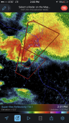
Alexandria storm really looks impressive now. Good couplet. Will go close to Woodworth.
 
  • Like
Reactions: KoD
FB Live video from Alexis Maricelli in Woodworth, LA. In warned area near Forrest Hill, LA
 
classic TWC.

Even with the alexandria cell, I'm still not seeing any of those cells to the south maturing enough. The Alexandria cell was more isolated for a bit before it really went tornadic, and it was sort of easy to see coming; of course the one semi-isolated cell in this environment is going to become a really dominant supercell.

It looks like a decently strong tornado, but it's hard to tell with KPOE down. Anybody have a stream or know of a chaser who's on the storm?
oh baby, turns out i had the wrong polling directory working and kpoe has been up the whole time. pretty insane signature.
 
CAMs tomorrow are slightly concerning for Central/Northern Georgia, and South Carolina. All about mesoscale evolution, and will need to be watched.
 
And perhaps a debris signature as well... concerning major drop in CC at the couplet
 
tornado emergency for alexandria. Good call. Nothing to undercut it, it's likely gonna just keep getting bigger and stronger for a while. appears to have been down for about 15 minutes.
 
C8bgEQiUMAEJwGU.jpg
 
Definitely looks like twin couplets now. Occlusion perhaps?

Unfortunately the eastern couplet will be a quite close call for Alexandria. Seems to be ramping up pretty quickly.
 
Back
Top