- Moderator
- #1
A thread to discuss the 3/17-3/19, 2022 severe risk.
Last edited:
Follow along with the video below to see how to install our site as a web app on your home screen.
Note: This feature may not be available in some browsers.


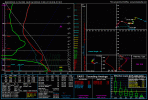
NAM seems to be depicting cells forming after the MCS moves out of the area. Those cells look like troublemakers, if they do indeed form.
View attachment 12578View attachment 12579
I would guess that it's a bit of an open question if they form with the usual caveats of a worked-over atmosphere, but the conditions behind the MCS look suitable for them if the air recovers. Obviously, will defer to the more experienced for a more concrete say on that matter.I was just about to edit my post to mention the 12Z 3KM NAM at the end of its run. It has a several hour window with no precip over MS/AL followed by those discrete cells developing and tracking into west AL by 00Z Saturday.
Friday morning:
Strong forcing for ascent and upper-level divergence from the
negative tilt trough will result in the development of an MCS
across the ArkLaMiss tonight. A 50-60 kts LLJ will maintain it as
it moves eastward, moving into West Alabama after 4 AM, and
reaching the Georgia state line by around midday. This MCS will be
north of the warm front/elevated, but with steep mid-level lapse
rates, 500 to 1000 J/kg of MUCAPE, and 70 kts of 0-6km bulk shear,
it will potentially produce the first round of severe storms
mainly across the southern half of Central Alabama. Potential AM
threats would include quarter size hail from any elevated
supercells and damaging wind gusts wherever stronger downdrafts
can make it through a near-surface stable layer. This would most
likely not include tornadoes. The exception would be if some of
the slower solutions or the solutions that are less organized on
the southern end of the convection verify. In that case, there
would be a risk of storms becoming surface-based in our far
southeastern counties by late morning which would result in a
more substantive tornado threat. However, at this time the most
likely scenario is that outflow from the MCS would keep this from
occurring. Additionally, localized flooding could occur, mainly in
areas that received heavy rainfall yesterday.
Friday afternoon and evening:
Forecast confidence decreases regarding what happens by afternoon
behind the MCS. It can often be difficult to get air mass recovery
behind a morning MCS in March. Synoptic scale subsidence and
weak height rises will be present behind the shortwave and mid-
levels dry out with PWATs falling to 1 to 1.2 inches. At the same
time, however, low-level southwesterly flow brings in high theta-e
air at low-levels, beneath the mid-level dry slot. Models are in
good agreement on increasing SBCAPE values to around 2000 J/kg,
with 0-6 km bulk shear values still around 60 to 70 kts, west of a
outflow-reinforced warm front draped somewhere along/east of I-65.
There is an upper-level jet max approaching from the west
bringing a little divergence, and some guidance does indicate a
subtle 700mb speed max/vort max which could provide a subtle
trigger. Current thinking is a least a couple strong to severe
supercells will re-develop Friday afternoon, but overall storm
coverage would be scattered in nature. This would provide a
conditional threat of quarter to golf ball size hail, and damaging
winds due to the steep low-level lapse rates/dry air aloft. The
threat for tornadoes is conditional as well but potentially
impactful. Non convectively-contaminated forecasting soundings in
the warm sector generally indicate fairly straight hodographs due
to veered low-level flow. However, there will be some localized
backing of the winds near the warm front, perhaps along the I-65
corridor, and some models also show some sharpening to the cold
frontal pressure trough. In this corridor a axis of enhanced STP
values may evolve, but placement of this area is uncertain. Stay
tuned for updates as we get closer to the event.