
Haven't been paying attention to this one (Friday) as much as I should be, but one look at the 500 mb shortwave tomorrow should be setting off some alarm bells assuming adequate recovery occurs and the near-surface winds stay close to southerly. The Ohio Valley could be interesting as well should enough moisture get north.
Navigation
Install the app
How to install the app on iOS
Follow along with the video below to see how to install our site as a web app on your home screen.
Note: This feature may not be available in some browsers.
More options
-
Welcome to TalkWeather! We see you lurking around TalkWeather! Take the extra step and join us today to view attachments, see less ads and maybe even join the discussion. CLICK TO JOIN TALKWEATHER
You are using an out of date browser. It may not display this or other websites correctly.
You should upgrade or use an alternative browser.
You should upgrade or use an alternative browser.
Severe Weather Threat 3/17-3/19, 2022
- Thread starter Taylor Campbell
- Start date
CheeselandSkies
Member
Haven't been paying attention to this one (Friday) as much as I should be, but one look at the 500 mb shortwave tomorrow should be setting off some alarm bells assuming adequate recovery occurs and the near-surface winds stay close to southerly. The Ohio Valley could be interesting as well should enough moisture get north.
Right on cue, enhanced risk upgrade (Edit: With a 10 hatched torprob) and more of northern AL and TN upgraded to slight risk on the updated Day 2.
This is one of those soundings where there's not a tremendous amount of hodograph curvature, yet there's still plenty of SRH and substantial 0-3KM CAPE.
Attachments
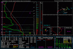
What's the location for that sounding?Right on cue, enhanced risk upgrade and more of northern AL and TN upgraded to slight risk on the updated Day 2.
This is one of those soundings where there's not a tremendous amount of hodograph curvature, yet there's still plenty of SRH and substantial 0-3KM CAPE.
CheeselandSkies
Member
What's the location for that sounding?
Near Decatur, AL.
Latest SPC update discussion on afternoon threat in AL/TN.
... Central AL to Middle TN Friday Afternoon...
Once morning convection shifts eastward, a secondary severe threat
may develop across parts of central/northern AL into Middle TN ahead
of the eastward-advancing cold front. The cold front is forecast to
extend from western TN into central MS and south-central LA around
20z Friday. Ahead of the front, moderate southerly low-level flow
will transport mid to upper 60s dewpoints as far north as Middle TN.
Clearing skies behind morning convection should allow for a few
hours of heating, and cooling aloft will steepen midlevel lapse
rates. As a result, an increasingly unstable boundary-layer with
1000-2000 J/kg is forecast. Vertical shear will remain strong and
favorable for supercells and isolated to widely-scattered severe
storms are expected to bring a risk for tornadoes, hail and damaging
gusts.
MattPetrulli
Member
Think SPC went 10% hatched over 12z HRRR showing a couple of supercells taking advantage of favorable conditions in Southern AL, 18z HRRR was a downgrade showing pretty messy convective evolution in mid morning-afternoon for that hatched area. Something to watch to see if it's a trend or not.
MattW
Member
- Messages
- 388
- Reaction score
- 382
- Location
- Decatur, GA
- HAM Callsign
- KG4GUF
- Special Affiliations
- SKYWARN® Volunteer
It's interesting to me that you're kind of downplaying the hype for mid week, but here you're basically doing the opposite. I trust you and your analyses implicitly, even if you're rarely talking about the areas I'm concerned about (I chase mostly Georgia, this time though I intend to get into Alabama), so this is a little concerning (or exciting if you're a chaser like me).In setups like this, you will usually hear that the afternoon threat just ahead of the front is all conditional based on how much the atmosphere recovers behind the morning activity, and then when things fail to fire, you hear people blindly say that the atmosphere just did not grow unstable again. More often than not, that is actually not true. The thing that usually fouls up afternoon redevelopment on days like this is a focus for low-level convergence is taken away from the frontal zone by the morning action and how it shifts the low-level jet away from the area by the afternoon. Because of this, you often get winds that veer too much just above the surface, and you are left with not enough low-level lift along the front to get sustained updrafts to form in the mid-level dry air. It's highly unsurprising that the models are recovering CAPE values by afternoon the way they are. They usually do in setups like this. Mid-level dry air will allow the sun to break out, and portions of north Alabama may be in the mid 70s by 3:00 or 4:00 tomorrow afternoon. The question is where there will be enough lift to get storms to refire. An awful lot of the CAMs think that at least low-topped discrete storms refire in the afternoon. You're not looking for big discrete storms with massive UH tracks in a setup like that.
Particularly telling to me is that the 12k (non-CAM) NAM fires off a few discrete updrafts in that environment, and its whole convective parameterization scheme is explicitly designed, intentionally, to not initialize convection in mid-level dry air (the reason why we see it underdo convective coverage in a lot of EML tornado setups). It's also telling me that the surface winds stay backed to the SSE ahead of the afternoon front/pressure trough even on the models that often underdo low-level backing and isallobaric responses (GFS and NAM).
I think that even if tomorrow afternoon verifies at full potential, it's probably still a SLGT Risk/tornado watch type of event. I just think it's a little more possible that it may realize something close to that tomorrow than it is in most events where we have a coastal threat, morning non-severe here, and then we wait for afternoon recovery. It's still very questionable and has substantial bust potential though. The thing next week has a more significant ceiling (strong tornadoes), but there's a LOT of uncertainty with it, and even on the most bullish solutions, it doesn't look quite as scary here locally as it's being made out to be by some.It's interesting to me that you're kind of downplaying the hype for mid week, but here you're basically doing the opposite. I trust you and your analyses implicitly, even if you're rarely talking about the areas I'm concerned about (I chase mostly Georgia, this time though I intend to get into Alabama), so this is a little concerning (or exciting if you're a chaser like me).
- Moderator
- #29
Certainly, thanks
MattPetrulli
Member
Assuming

Despite it being messy, at least on 18z, HRRR continues to put out a pretty decent environment for tornadoes tomorrow in that hatched, so seems like a good just incase kind of call for SPC.Think SPC went 10% hatched over 12z HRRR showing a couple of supercells taking advantage of favorable conditions in Southern AL, 18z HRRR was a downgrade showing pretty messy convective evolution in mid morning-afternoon for that hatched area. Something to watch to see if it's a trend or not.
Equus
Member
CAMs are generally showing a very good environment behind the line across north/central AL with hodos recovering (still SSW and not ideal but shown to back at least a little bit from SW once the MCS leaves) that said I'm not sure about thermos recovering way too much after that initial line; most of the CAMs want to bring dews >65 by afternoon but that may be generous if the early QLCS brings a good bit of trailing precip and cloud cover. Both WRF models and the NAM are pretty aggressive on advection behind it but that's not always something accurately sniffed out by models; will be something to watch on surface observations after the rain ends. If we get clouds clearing out fast and some strong 925mb flow from the GOM, it'll definitely be an interesting evening.
Last edited:
Equus
Member
New HRRR run veers winds not too long after the MCS passes with SW winds much of the way up the hodo, not ideal for tornadic supercells here but we'll know more with surface obs tomorrow
There's very substantial mid-level dry air behind the morning round tomorrow, and the core of the upper-level jet will be directly overhead and will be very westerly. There's no way we don't both clear out the morning stuff and get breaks in the cloud cover. The main question mark is whether we have the low-level convergence and lift needed to get updrafts to survive that degree of mid-level dry air. The more I'm looking at things, the more iffy I'm thinking it is for areas west of I-65, even if the surface winds stay more backed. They quickly veer toward southwesterly just above the surface. Any convergence likely won't be too deep through the boundary layer.CAMs are generally showing a very good environment behind the line across north/central AL with hodos recovering (still SSW and not ideal but shown to back at least a little bit from SW once the MCS leaves) that said I'm not sure about thermos recovering way too much after that initial line; most of the CAMs want to bring dews >65 by afternoon but that may be generous if the early QLCS brings a good bit of trailing precip and cloud cover. Both WRF models and the NAM are pretty aggressive on advection behind it but that's not always something accurately sniffed out by models; will be something to watch on surface observations after the rain ends. If we get clouds clearing out fast and some strong 925mb flow from the GOM, it'll definitely be an interesting evening.
CheeselandSkies
Member
Small area of 10% hatching added for possible significant tornadoes overnight in eastern LA/far southwestern MS.
*Edit: Broyles'd. Certainly bears watching, though. Last few runs of the HRRR have some nasty cells down there in the 08Z-12Z timeframe. Discrete tornadic supercells at odd times of the night/morning are always a recipe for trouble.
*Edit: Broyles'd. Certainly bears watching, though. Last few runs of the HRRR have some nasty cells down there in the 08Z-12Z timeframe. Discrete tornadic supercells at odd times of the night/morning are always a recipe for trouble.
MattW
Member
- Messages
- 388
- Reaction score
- 382
- Location
- Decatur, GA
- HAM Callsign
- KG4GUF
- Special Affiliations
- SKYWARN® Volunteer
It looks like the CAMs are starting to show development behind the MCS.
Austin Dawg
Member
Equus
Member
Tornado driven hatched Enhanced pulled all the way to the southern Birmingham metro (Hoover and Vestavia Hills)

Austin Dawg
Member
Ft Polk, LA 1:35 CST

CheeselandSkies
Member
SPC tacitly admitting bust on their (and the HRRR's) overnight significant tornado forecast. MD 275:
Based on the progression of this line, latest
surface observations, and most recent MLCAPE fields from
mesoanalysis, it still appears that this activity is outpacing the
greater low-level moisture return occurring along the central Gulf
Coast. There has been a notable lack of severe wind/damage reports
thus far, and much of the ongoing convection may still be rooted
slightly above the surface.
Bama Ravens
Member
SPC has moved the enhanced risk area back to the south towards the Gulf Coast. Hopefully the storms this morning will limit the severe threat for north and central AL this afternoon.

