
Navigation
Install the app
How to install the app on iOS
Follow along with the video below to see how to install our site as a web app on your home screen.
Note: This feature may not be available in some browsers.
More options
-
Welcome to TalkWeather! We see you lurking around TalkWeather! Take the extra step and join us today to view attachments, see less ads and maybe even join the discussion. CLICK TO JOIN TALKWEATHER
You are using an out of date browser. It may not display this or other websites correctly.
You should upgrade or use an alternative browser.
You should upgrade or use an alternative browser.
Severe WX Severe Weather Threat 3/14-3/16
- Thread starter Bulkshear
- Start date
- Messages
- 751
- Reaction score
- 2,465
- Location
- Mississippi State University
- Special Affiliations
- SKYWARN® Volunteer
Amory/Monroe County finally warned. @JPWX
US_Highway15
Member
New MCD for Tornado Watches 45 and 46:
"
SUMMARY...The risk for tornadoes continues across northern MS into
northwestern AL, particularly with a supercell in Montgomery County.
Intense tornadoes (EF3+) are possible.
DISCUSSION...A QLCS has evolved into more discrete supercells, some
of which have become dominant relative to other convective elements
in the area. Some of these storms have a history of tornadoes, and a
supercell in Montgomery County, MS has a persistent mesocyclone that
continues to intensify per KDGX and KGWX NEXRAD data. The GWX VAD
shows an impressively large and curved hodograph, with nearly 500
m2/s2 effective SRH in just the surface-500 m layer, with about 1000
m2/s2 SRH in the sfc-3 km layer. As such, the ambient environment
supports intense tornadoes (EF3+). However, this is contingent on
storms benefiting from minimal interference by other nearby storms,
including the absorption of smaller storms. If one of the more
dominant storms (especially the Montgomery County storm) can obtain
a pristine inflow environment, the chance for intense tornado
development is high. Damaging gusts are possible, especially with
any linear segments that materialize.
The orientation of those showers are doing the same thing as the smaller confluence bands in MS did earlier. They’re running off directly to the north instead of north and east. The deep layer shear vectors are probably more parallel than perpendicularYeah seems like the showers in W AL. are still having a hard time getting their act together...
- Thread starter
- #5,245
Bulkshear
Member
Sun is out in middle TN! I smell trouble as the storms propagate NE into the state

hurricaneguy
Member
I'm hoping the forecasted storm potential over Alabama may be over enhanced based on current observations. Not nearly as primed as Mississippi yet.
OHWX97
Member
Back on the ground, doing damage south of Prentiss.

It took them long enoughAmory/Monroe County finally warned. @JPWX
Western_KS_Wx
Member
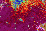
Debris ball has returned with the significant tornado west of Bassfield.
jiharris0220
Member
AJS
Member
Bassfield….Back on the ground, doing damage south of Prentiss.
View attachment 36130

NorthBamaWX
Member
Tornado reported in Smithville Miss
- Messages
- 751
- Reaction score
- 2,465
- Location
- Mississippi State University
- Special Affiliations
- SKYWARN® Volunteer
Is Jackson radar struggling for y'all? Says my most recent scan was 20 minutes ago.
Teche
Member
heading for Carson, MSBack on the ground, doing damage south of Prentiss.
View attachment 36130
Attachments


Yes it's been lagging a bit.Is Jackson radar struggling for y'all? Says my most recent scan was 20 minutes ago.
Another potential tornadic storm moving near Tyler town.