Anti Marine Layer
Member
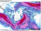
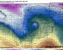
It’s time to start this thread at this point. Too many models on board with a significant event. First picture is showing the low barometric pressure of this thing. Crazy….
Welcome to the forums
Follow along with the video below to see how to install our site as a web app on your home screen.
Note: This feature may not be available in some browsers.
It’s time to start this thread at this point. Too many models on board with a significant event. First picture is showing the low barometric pressure of this thing. Crazy….
As someone who has lived here all their life, Georgia is absolutely weird. There are some areas that get tornadoes paraded through more regularly than others too. To your point though, it feels like 90% of my tornado warnings are overnight vs occurring during the day outside of *maybe* mid April.Georgia gets spared about 95% of the time by either the wedge or simple chronology, i.e. storms arriving at 4 A.M. Hoping this'll be the case once more.
Yep, we're a weird state. When we do have significant tornado events, they hit with vengeance, and nighttime tornado setups are absolutely no fun. I think I'd rather contend with a daytime threat, considering how many sleepless nights I've had over the years from midnight storms.As someone who has lived here all their life, Georgia is absolutely weird. There are some areas that get tornadoes paraded through more regularly than others too. To your point though, it feels like 90% of my tornado warnings are overnight vs occurring during the day outside of *maybe* mid April.
And that nocturnally carries over (without losing any of its seriousness) into north MS, northwest AL, and middle TN overnight Friday night and into about mid morning Saturday before becoming messy with time deeper into Saturday late morning or midday.Ok, probably time to start sounding some of the alarms on this one, all of the 00z models have a significant severe weather setup for Mid South (and some further north too). The 00z Euro is very dangerous across AR into LA and S MO/W TN.
agreed, I think we see a 15% next outlook cycleOk, probably time to start sounding some of the alarms on this one, all of the 00z models have a significant severe weather setup for Mid South (and some further north too). The 00z Euro is very dangerous across AR into LA and S MO/W TN.
The GFS was no slouch for east of the MS River Valley either, but the timing was a little different. It was bringing the eastern edge of the nocturnal tornado threat over to about Highway 43 in northwest Alabama and middle Tennessee before the initial energy would lift north... and then a round 2 late morning to early evening on Saturday over east MS/north-central AL/southern middle TN that was an aggressively tornadic QLCS that might would have the potential for embedded strong tornadoes. Euro, however, would be much more in the way of a supercellular tornado threat. GFS, with time, is trending less sharp with its trough and inching toward the Euro's trough evolution as well.And that nocturnally carries over (without losing any of its seriousness) into north MS, northwest AL, and middle TN overnight Friday night and into about mid morning Saturday before becoming messy with time deeper into Saturday late morning or midday.
How does the spacing parameter s look like to you Fred on the euro…. See any potential risk for some discrete activity ? When u mention super celluar typeThe GFS was no slouch for east of the MS River Valley either, but the timing was a little different. It was bringing the eastern edge of the nocturnal tornado threat over to about Highway 43 in northwest Alabama and middle Tennessee before the initial energy would lift north... and then a round 2 late morning to early evening on Saturday over east MS/north-central AL/southern middle TN that was an aggressively tornadic QLCS that might would have the potential for embedded strong tornadoes. Euro, however, would be much more in the way of a supercellular tornado threat. GFS, with time, is trending less sharp with its trough and inching toward the Euro's trough evolution as well.
How does the spacing parameter s look like to you Fred on the euro…. See any potential risk for some discrete activity ? When u mention super celluar type
And that nocturnally carries over (without losing any of its seriousness) into north MS, northwest AL, and middle TN overnight Friday night and into about mid morning Saturday before becoming messy with time deeper into Saturday late morning or midday.
The GFS, with time, is trending toward the Euro.Which solution are you leaning towards? GFS or Euro?
oh manThe GFS was no slouch for east of the MS River Valley either, but the timing was a little different. It was bringing the eastern edge of the nocturnal tornado threat over to about Highway 43 in northwest Alabama and middle Tennessee before the initial energy would lift north... and then a round 2 late morning to early evening on Saturday over east MS/north-central AL/southern middle TN that was an aggressively tornadic QLCS that might would have the potential for embedded strong tornadoes. Euro, however, would be much more in the way of a supercellular tornado threat. GFS, with time, is trending less sharp with its trough and inching toward the Euro's trough evolution as well.
Ok do you think we get that secondary low developing just east of the Mississippi River? I noticed the GFS has it but the Euro lacks this featureThe GFS, with time, is trending toward the Euro.
Some of that is sometimes related to convective feedback in the GFS. However, it's not needed. There are still appreciable pressure falls and backed due southerly surface winds way out over the warm sector on the Euro at face value. Remember, in Dixie Alley, we don't want southeasterly surface winds on the large scale if we're looking for an appreciable threat. That means we aren't advecting from a rich moisture source. Historically, the vast majority of our big tornado events in the heart of the Southeast happen with surface winds that range from SSE to SSW, and due south is historically optimal.Ok do you think we get that secondary low developing just east of the Mississippi River? I noticed the GFS has it but the Euro lacks this feature
Well I did notice some kinks in the isobars on the Euro model. Couldn’t this indicate enhanced backing of the winds? If I am off base please let me know but I couldn’t help but notice the kinks.Some of that is sometimes related to convective feedback in the GFS. However, it's not needed. There are still appreciable pressure falls and backed due southerly surface winds way out over the warm sector on the Euro at face value. Remember, in Dixie Alley, we don't want southeasterly surface winds on the large scale if we're looking for an appreciable threat. That means we aren't advecting from a rich moisture source. Historically, the vast majority of our big tornado events in the heart of the Southeast happen with surface winds that range from SSE to SSW, and due south is historically optimal.
Those could be small-scale things that, if there, would help back low-level winds... but the environment has 0-1 km SRH of 400+ over middle TN at 6z Saturday even with the face-value modeled due south surface winds shown. The wind profiles shown as is would already support major tornadoes without any additional low-level backing.Well I did notice some kinks in the isobars on the Euro model. Couldn’t this indicate enhanced backing of the winds? If I am off base please let me know but I couldn’t help but notice the kinks.
woow, seems like we have a rather robust event on our handsThose could be small-scale things that, if there, would help back low-level winds... but the environment has 0-1 km SRH of 400+ over middle TN at 6z Saturday even with the face-value modeled due south surface winds shown. The wind profiles shown as is would already support major tornadoes without any additional low-level backing.