CheeselandSkies
Member
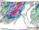
Some of that is sometimes related to convective feedback in the GFS. However, it's not needed. There are still appreciable pressure falls and backed due southerly surface winds way out over the warm sector on the Euro at face value. Remember, in Dixie Alley, we don't want southeasterly surface winds on the large scale if we're looking for an appreciable threat. That means we aren't advecting from a rich moisture source. Historically, the vast majority of our big tornado events in the heart of the Southeast happen with surface winds that range from SSE to SSW, and due south is historically optimal.
This setup is a good demonstration because of the preceding wave causing drying of the air over FL/GA, if you had southeasterly winds you'd have the same problem as the last system where the warm sector would have a lot of trouble moistening except in a narrow strip just ahead of the front. With less of an easterly component this time you don't have that to the same extent even though the preceding wave is still there.


