TH2002
Member
- Messages
- 4,974
- Reaction score
- 11,116
- Location
- California, United States
- Special Affiliations
- SKYWARN® Volunteer
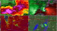
It's probably hitting homes north of Lakeview. Not good at all...You spoke too soon man lol View attachment 24294
Follow along with the video below to see how to install our site as a web app on your home screen.
Note: This feature may not be available in some browsers.
It's probably hitting homes north of Lakeview. Not good at all...You spoke too soon man lol View attachment 24294
Stay safe, please!im not quite sure what the short term evolution of things are but seeing this all go down while seeing hodos more favorable in SE IN/ SW OH doesnt make me feel too great
And on the northern side of Dallas, to boot!Now we've got a tornado warning in Texas.

Just a TORR. From radar, it looks to have hit this area.Was there not a tornado emergency???

No, I don't think so.Was there not a tornado emergency???
Ugh. Hope as many people got away from there as couldMoving right over RV parks and houses, unfortunately.
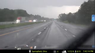
View attachment 24297


BULLETIN - EAS ACTIVATION REQUESTED
Tornado Warning
National Weather Service Wilmington OH
751 PM EDT Thu Mar 14 2024
The National Weather Service in Wilmington has issued a
* Tornado Warning for...
Central Logan County in west central Ohio...
Northwestern Union County in central Ohio...
* Until 830 PM EDT.
* At 750 PM EDT, a large and extremely dangerous tornado was located
near Russells Point, moving east at 40 mph.
This is a PARTICULARLY DANGEROUS SITUATION. TAKE COVER NOW!
HAZARD...Damaging tornado.
SOURCE...Radar indicated rotation.
IMPACT...You are in a life-threatening situation. Flying debris
may be deadly to those caught without shelter. Mobile
homes will be destroyed. Considerable damage to homes,
businesses, and vehicles is likely and complete
destruction is possible.
* Locations impacted include...
Bellefontaine, Russells Point, Lakeview, Belle Center, West
Mansfield, Chippewa Park, Northwood, Rushsylvania, Huntsville,
Ridgeway, Valley Hi, Zanesfield, Raymond, New Jerusalem, Byhalia,
Broadway, Middleburg, Mcmorran, Somersville, and Big Springs.
PRECAUTIONARY/PREPAREDNESS ACTIONS...
To repeat, a large, extremely dangerous and potentially deadly
tornado is on the ground. To protect your life, TAKE COVER NOW! Move
to a basement or an interior room on the lowest floor of a sturdy
building. Avoid windows. If you are outdoors, in a mobile home, or in
a vehicle, move to the closest substantial shelter and protect
yourself from flying debris.
To report severe weather, go to our website at weather.gov/iln and
submit your report via social media, when you can do so safely.
&&
LAT...LON 4050 8339 4033 8338 4025 8343 4036 8384
4043 8394 4052 8391
TIME...MOT...LOC 2350Z 287DEG 35KT 4049 8389
TORNADO...RADAR INDICATED
TORNADO DAMAGE THREAT...CONSIDERABLE
MAX HAIL SIZE...1.25 IN
$$
Hatzos