atrainguy
Member
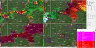
PDS for Indiana too.
Follow along with the video below to see how to install our site as a web app on your home screen.
Note: This feature may not be available in some browsers.
BULLETIN - EAS ACTIVATION REQUESTED
Tornado Warning
National Weather Service Indianapolis IN
803 PM EDT Thu Mar 14 2024
The National Weather Service in Indianapolis has issued a
* Tornado Warning for...
Northeastern Randolph County in east central Indiana...
* Until 845 PM EDT.
* At 802 PM EDT, a confirmed large and extremely dangerous tornado
was located over Winchester, or 17 miles southeast of Dunkirk,
moving east at 40 mph.
This is a PARTICULARLY DANGEROUS SITUATION. TAKE COVER NOW!
HAZARD...Damaging tornado.
SOURCE...Weather spotters confirmed tornado. At 800 PM EDT, a
tornado was confirmed just northwest of Winchester by
spotters.
IMPACT...You are in a life-threatening situation. Flying debris
may be deadly to those caught without shelter. Mobile
homes will be destroyed. Considerable damage to homes,
businesses, and vehicles is likely and complete
destruction is possible.
* The tornado will be near...
Union City around 815 PM EDT.
PRECAUTIONARY/PREPAREDNESS ACTIONS...
To repeat, a large, extremely dangerous and potentially deadly
tornado is on the ground. To protect your life, TAKE COVER NOW! Move
to a basement or an interior room on the lowest floor of a sturdy
building. Avoid windows. If you are outdoors, in a mobile home, or in
a vehicle, move to the closest substantial shelter and protect
yourself from flying debris.
Tornadoes are extremely difficult to see and confirm at night. Do not
wait to see or hear the tornado. TAKE COVER NOW!
&&
LAT...LON 4014 8509 4027 8505 4026 8480 4007 8481
TIME...MOT...LOC 0002Z 280DEG 34KT 4018 8500
TORNADO...OBSERVED
TORNADO DAMAGE THREAT...CONSIDERABLE
MAX HAIL SIZE...2.50 IN
Hell that's a wild day even by May standards
MESOSCALE DISCUSSION 0244
NWS STORM PREDICTION CENTER NORMAN OK
0656 PM CDT THU MAR 14 2024
AREAS AFFECTED...SOUTHEASTERN INDIANA INTO PORTIONS OF
SOUTHWEST/SOUTH-CENTRAL OHIO
CONCERNING...TORNADO WATCH 44...
VALID 142356Z - 150100Z
THE SEVERE WEATHER THREAT FOR TORNADO WATCH 44 CONTINUES.
SUMMARY...AN AREA OF GREATER TORNADO POTENTIAL IS EVIDENT FROM
SOUTHEAST INDIANA INTO SOUTHWESTERN OHIO OVER THE NEXT 1-3 HOURS.
DISCUSSION...THREE SUPERCELLS FROM JUST EAST OF INDIANAPOLIS TO
NORTHWEST OF COLUMBUS, OH HAVE SHOWN A RIGHTWARD TURN TO THE
SOUTHEAST. SURFACE FLOW REMAINS BACKED IN SOUTHWESTERN PORTIONS OF
OHIO. CONSIDERING THE OBSERVED STORM MOTION AND REGIONAL VAD
PROFILES, AN AREA OF GREATER TORNADO THREAT IS EVIDENT FROM
SOUTHEASTERN INDIANA INTO SOUTHWESTERN OHIO. 850 MB WINDS ARE
EXPECTED TO INCREASE THIS EVENING AS WELL. SHOULD STORMS REMAIN
DISCRETE AND SURFACE WIND BACKED, THE ENVIRONMENT WOULD BECOME MORE
FAVORABLE IN THE NEXT 1-3 HOURS.

No kidding...this is far from over