Tanner
Member
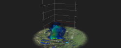
I'm saying!! Absolutely terrifying and beautiful all from the same scope!This thing belongs in textbooks.
View attachment 24223
Follow along with the video below to see how to install our site as a web app on your home screen.
Note: This feature may not be available in some browsers.
I'm saying!! Absolutely terrifying and beautiful all from the same scope!This thing belongs in textbooks.
View attachment 24223
Appears to be exactly the case.Guess it latched onto the warm front?

Occluded a few minutes ago, but looks like it could put down at any time. And that velocity is not to be trifled with.Anyone with radar, if you look up in tilt you can see a separate rotation displaced from the main one south and east. Likely attempting a recycle and another tornado here.


780
WWUS53 KTOP 140133
SVSTOP
Severe Weather Statement
National Weather Service Topeka KS
833 PM CDT Wed Mar 13 2024
KSC085-149-177-197-140145-
/O.CON.KTOP.TO.W.0004.000000T0000Z-240314T0145Z/
Shawnee-Wabaunsee-Pottawatomie-Jackson-
833 PM CDT Wed Mar 13 2024
...A TORNADO WARNING REMAINS IN EFFECT UNTIL 845 PM CDT FOR
NORTHWESTERN SHAWNEE...NORTHEASTERN WABAUNSEE...SOUTHEASTERN
POTTAWATOMIE AND SOUTHWESTERN JACKSON COUNTIES...
At 833 PM CDT, a confirmed tornado was located over Rossville, moving
northeast at 20 mph.
HAZARD...Damaging tornado and baseball size hail.
SOURCE...Weather spotters confirmed tornado just north of Rossville.
IMPACT...Flying debris will be dangerous to those caught without
shelter. Mobile homes will be damaged or destroyed. Damage
to roofs, windows, and vehicles will occur. Tree damage is
likely.
Locations impacted include...
Rossville, St. Marys, Maple Hill, and Delia.
PRECAUTIONARY/PREPAREDNESS ACTIONS...
To repeat, a tornado is on the ground. TAKE COVER NOW! Move to a
basement or an interior room on the lowest floor of a sturdy
building. Avoid windows. If you are outdoors, in a mobile home, or in
a vehicle, move to the closest substantial shelter and protect
yourself from flying debris.
Tornadoes are extremely difficult to see and confirm at night. Do not
wait to see or hear the tornado. TAKE COVER NOW!
&&
LAT...LON 3921 9573 3906 9602 3913 9611 3923 9609
3926 9603
TIME...MOT...LOC 0133Z 227DEG 15KT 3916 9595
TORNADO...OBSERVED
MAX HAIL SIZE...2.75 IN
$$
Jones
======================================================================
773
WFUS53 KTOP 140119
TORTOP
KSC085-149-177-197-140145-
/O.NEW.KTOP.TO.W.0004.240314T0119Z-240314T0145Z/
BULLETIN - EAS ACTIVATION REQUESTED
Tornado Warning
National Weather Service Topeka KS
819 PM CDT Wed Mar 13 2024
The National Weather Service in Topeka has issued a
* Tornado Warning for...
Northwestern Shawnee County in east central Kansas...
Northeastern Wabaunsee County in east central Kansas...
Southeastern Pottawatomie County in northeastern Kansas...
Southwestern Jackson County in northeastern Kansas...
* Until 845 PM CDT.
* At 819 PM CDT, a severe thunderstorm capable of producing a tornado
was located near Maple Hill, moving northeast at 15 mph.
HAZARD...Tornado and baseball size hail.
SOURCE...Radar indicated rotation.
IMPACT...Flying debris will be dangerous to those caught without
shelter. Mobile homes will be damaged or destroyed.
Damage to roofs, windows, and vehicles will occur. Tree
damage is likely.
* Locations impacted include...
Rossville, St. Marys, Maple Hill, and Delia.
PRECAUTIONARY/PREPAREDNESS ACTIONS...
TAKE COVER NOW! Move to a basement or an interior room on the lowest
floor of a sturdy building. Avoid windows. If you are outdoors, in a
mobile home, or in a vehicle, move to the closest substantial shelter
and protect yourself from flying debris.
Tornadoes are extremely difficult to see and confirm at night. Do not
wait to see or hear the tornado. TAKE COVER NOW!
&&
LAT...LON 3921 9573 3906 9602 3913 9611 3923 9609
3926 9603
TIME...MOT...LOC 0119Z 221DEG 14KT 3912 9604
TORNADO...RADAR INDICATED
MAX HAIL SIZE...2.75 IN
$$
Jones