BULLETIN - EAS ACTIVATION REQUESTED
Tornado Warning
National Weather Service Jackson MS
756 PM CST Sat Dec 28 2024
The National Weather Service in Jackson has issued a
* Tornado Warning for...
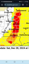
Jasper County in east central Mississippi...
Newton County in east central Mississippi...
Northeastern Smith County in central Mississippi...
Southeastern Scott County in central Mississippi...
* Until 900 PM CST.
* At 755 PM CST, severe thunderstorms capable of producing a tornado
were located along a line extending from near Walnut Grove to near
Pineville to Taylorsville, moving east at 50 mph.
HAZARD...Tornado.
SOURCE...Radar indicated rotation.
IMPACT...Flying debris will be dangerous to those caught without
shelter. Mobile homes will be damaged or destroyed.
Damage to roofs, windows, and vehicles will occur. Tree
damage is likely.
* These dangerous storms will be near...
Conehatta, Bay Springs, Prospect, Lake, and Sebastopol around 800
PM CST.
Montrose, Lawrence, Roberts, Stringer, and Louin around 805 PM
CST.
Turnerville, Stratton, Newton, and Union around 810 PM CST.
Garlandville, Decatur, and Vernon around 815 PM CST.
Paulding, Little Rock, and Hickory around 820 PM CST.
Heidelberg and Rose Hill around 825 PM CST.
Stafford Springs, Duffee, Orange, and Chunky around 830 PM CST.
PRECAUTIONARY/PREPAREDNESS ACTIONS...
TAKE COVER NOW! Move to a basement or an interior room on the lowest
floor of a sturdy building. Avoid windows. If you are outdoors, in a
mobile home, or in a vehicle, move to the closest substantial shelter
and protect yourself from flying debris.
This line of thunderstorms is capable of producing tornadoes and
widespread significant wind damage. Do not wait to see or hear the
tornado. For your protection move to an interior room on the lowest
floor of a building.