Ledian
Member
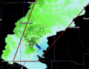
Look for a possible CC drop south of Brookhaven in the next few scans...that is a nasty velocity signature.
Follow along with the video below to see how to install our site as a web app on your home screen.
Note: This feature may not be available in some browsers.
Yeah. I'm wondering as that section of the line bowes out (atleast that's what I had been seeing from the HRRR) in the coming hours if the tornadoes will increase, because it'll make tornadogenesis more likely with the angles.Not envying NWS warning coordinators tonight.
View attachment 32306


Not a met, but that seems like a problem near Brookhaven.
View attachment 32312

This looks bad.
It is definitely trying.Brookhaven certainly has "the look" on reflectivity of a classic supercell tornado.