jiharris0220
Member
Supercell in Dickson looks like it could drop another tornado at any moment.

Follow along with the video below to see how to install our site as a web app on your home screen.
Note: This feature may not be available in some browsers.
PDS Tornado Watch coming for parts of Louisiana into Central MS
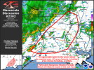
Mesoscale Discussion 2302
NWS Storm Prediction Center Norman OK
0134 PM CST Sat Dec 28 2024
Areas affected...portions of eastern Texas into Louisiana...western
Mississippi...and extreme southeastern Arkansas
Concerning...Severe potential...Tornado Watch likely
Valid 281934Z - 282100Z
Probability of Watch Issuance...95 percent
SUMMARY...The anticipated primary round of severe storms is expected
to take shape soon. A QLCS, likely preceded by supercells, with all
severe hazards expected. Several EF0-EF2 tornadoes are anticipated,
and a few intense (EF3+) tornadoes are likely. A particularly
dangerous situation tornado watch will be issued within the next
hour or so to address the increasing severe threat.
DISCUSSION...A QLCS is gradually organizing across eastern TX,
preceded by multiple supercells developing within confluence bands.
So far, tornadoes have been the predominant observed severe hazard,
with preliminary local storm reports suggesting that some of these
tornadoes may have been strong. Mesoanalysis trends have shown a 70
kt mid-level jet streak pivoting the trough and approaching the open
warm sector, characterized by 2000-2500 J/kg MLCAPE (given 7 C/km
mid-level lapse rates atop 70F surface dewpoints). As such, the 850
mb low-level jet has already increased to 40 kts, with regional VADs
beginning to show the first signs of low-level hodograph
enlargement.
Trends of increasing low-level shear across the warm sector should
continue into the evening hours ahead of the approaching QLCS and
supercells. Damaging tornado potential should not only persist, but
likely increase into the evening hours, both with the QLCS and
preceding supercells. The most discrete, dominant warm-sector
supercells will have the best potential to produce intense,
potentially long-lived/long-tracked tornadoes. In consideration of
the aforementioned significant tornado potential, a particularly
dangerous situation tornado watch is likely within the next hour.
..Squitieri/Hart.. 12/28/2024

Yikes.
Thankfully, there aren't a whole lot of population centers on the other side of the Bay.Fixing to have a strong waterspout over Galveston Bay.
Might have our second wedgespout in as many daysFixing to have a strong waterspout over Galveston Bay.