.LONG TERM...
(Sunday through Friday)
Issued at 438 AM EST
Sat Dec 28 2024
Changes from the previous forecast are small overall, but do include
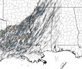
an expansion of the
Slight Risk to the north and east to encompass
an increased threat across northern Georgia Sunday morning into the
afternoon. Discussion of why can be found below. Overall
confidence of seeing a few severe storms in central Georgia is
high, with medium confidence in seeing some severe weather in
northern Georgia.
Synoptic setup remains the same as previous discussion.
Anticyclonic wave break along the equatorward flank of the upper
level
jet off the west coast will aid in creation of a strong PV
gradient as it pushes a piece of the Arctic
tropopause into the
Great Plains, allowing for
lee cyclogenesis and eventual
interaction with
baroclinic zone (
front) left in place by previous
systems. Translation -
shortwave digs into the Great Plains and
forms a surface low that will lift to the northeast and bring
additional rain and
thunderstorm chances to Georgia Saturday night
and Sunday as the system moves through.
Hi res models tonight are well within range of the frontal system
moving through the
CWA early Sunday and include information about
the afternoon on Sunday as well. One big trend seen over the past 24
hours worth of runs is for a deeper
trough and stronger jetstreak on
the eastern side of the
trough where the PV
gradient is strongest.
This drives a deeper low and overall stronger surface mass response,
bringing even stronger
WAA across the
CWA ahead of the initial
front. This has some interesting implications for the
CAD/wedge - in
theory, stronger
WAA over the top means a stronger
inversion as well
as increased precip/cloud cover that can reinforce it. However, this
also means a stronger
LLJ within that, and at 40-60
kts per many of
the
hi res models, that would
likely be enough to erode what is
already a relatively thin wedge via mixing processes, especially
given the surface high pressure driving it continues to move
offshore into the Atlantic. But...a NW positioned low to the
CWA is
also one of the most common failure modes for models in eroding the
wedge too fast. Quite the conundrum. (As an aside, for my budding
meteorologists out there, Gary Lackmann has a great paper discussing
the breakdown process of the wedge, including
climatology of
different mechanisms.)
In this forecast, leaning a bit more towards seeing some breakdown
of the wedge ahead of the
front. Believe that the mass response here
will be able to mix the wedge out to an extent. Think we still may
see some vestige of it holding out, especially if it gets a bit more
compressed (mass continuity says we would see a potential increase
in wedge
height, which could fight the mixing processes a bit), so
have kept high temps a bit lower when compared to the blend and much
of the
hi-res for areas around Athens in NE GA. This opens up north
Georgia for storms to be a bit more surfaced based, with an overall
severe
wx parameter space that is certainly promising.
Speaking of that
parameter space,
front with ongoing storms ahead
of it will approach the
CWA by 09-12Z (4-7am). Mode is expected
to be linear with QLCS elements, with a chance of a few discrete
storms ahead of it especially as we move into the afternoon hours.
HREF
ensemble means keep
SBCAPE on the lower side at only 100-500
J/kg. However, this will
likely be a low
CAPE high
shear event,
with HREF means of 150-250
m2/s2 of 0-1km
SRH overspreading the
area on Sunday. Hodographs are very tall within the lowest 3 km
and take on a bit of a fish hook shape thanks to the very strong
LLJ providing copious amounts of speed
shear. Add in to all of
this the ability for storms to ingest additional streamwise
vorticity along any remaining edge of the wedge, and any storm
which can get rotating will certainly be able to enhance its
updraft significantly thanks to plenty of available streamwise
vorticity for a
right mover. Primary threat will be damaging
winds, but can`t rule out seeing a few brief tornadoes across the
CWA. Not confident in seeing
hail, especially severe
hail, but
won`t rule it out completely.
As the system progresses east during the day on Sunday,
diurnal
heating and
WAA should allow for destabilization of the
warm sector,
possibly increasing the threat a bit into portions of eastern
Georgia. Forcing for storms isn`t great, as the main
shortwave has
lifted well out of the area by this time, but broad
trough remains
in place. Another change from yesterday is most models have a fairly
robust
cold pool that helps keep
convection moving into the area.