• Welcome to TalkWeather!
    We see you lurking around TalkWeather! Take the extra step and join us today to view attachments, see less ads and maybe even join the discussion.
    CLICK TO JOIN TALKWEATHER

Severe WX Severe Weather Event 3/28/17-3/31/17

TWBot

TalkWeather Bot
Don't Feed The Bots
Messages
542
Reaction score
2
Location
On a server
SPC 1630Z Day 1 Outlook


Day 1 Convective Outlook
NWS Storm Prediction Center Norman OK
1147 AM CDT Wed Mar 29 2017

Valid 291630Z - 301200Z

...THERE IS AN ENHANCED RISK OF SEVERE THUNDERSTORMS FROM THE
OZARKS/LOWER MO VALLEY SOUTHWARD TO LA/LOWER MS RIVER VALLEY...

...THERE IS A SLIGHT RISK OF SEVERE THUNDERSTORMS FROM THE
OZARKS/LOWER MO VALLEY SOUTHWARD TO LA/LOWER MS RIVER VALLEY...

...THERE IS A MARGINAL RISK OF SEVERE THUNDERSTORMS FROM EAST
TX/SOUTH-CENTRAL PLAINS TO MS RIVER VALLEY...

...SUMMARY...
Severe thunderstorms are expected later today into tonight from
parts of east Texas, eastern Oklahoma, and southeast Kansas into the
lower and middle Mississippi Valley. Large hail, tornadoes, and
damaging winds will be possible especially late this afternoon and
tonight.

...Ozarks/lower MO Valley to ArkLaTex/lower MS River Valley...
The closed upper trough currently over the south-central Plains at
late morning will continue a slow-general-northeastward advance
toward the lower MO River Valley through late tonight and early
Thursday. Ahead of this system, 12Z regional observed soundings
reflected considerable lapse-rate-related impacts from the
overnight/early morning squall line that continues to move generally
east-northeastward and decay across the Ozarks and Ark-La-Tex
vicinity. This may have ramifications on the
extensiveness/likelihood of significant hail potential, for
instance, although the air mass will recover/gradually moisten and
destabilize to the south of a northward-moving warm front across the
Ozarks/lower MO Valley, and ahead (east) of a slow-eastward-moving
cold front.

Latest thinking is that surface-based storms will develop as early
as mid-afternoon near the eastern KS surface low southward along the
front, including far eastern portions of KS/OK into western portions
of MO/AR. Moderate low-level hodograph curvature (beneath strong but
somewhat backed mid-level southwesterly winds) and resultant strong
low-level shear/SRH will support a tornado risk aside from large
hail and evolving damaging wind risk into this evening.

Farther south, storms may diurnally be a bit more isolated across
the remainder of the ArkLaTex vicinity, although an ongoing
quasi-linear cluster across near-coastal southeast TX may persist
east-northeastward into LA as it favors a zone of outflow-related
weak boundary/zone of differential heating. This cluster and other
peripheral development may pose a damaging wind/tornado risk through
the afternoon and evening hours.

Later tonight, storms should increase in coverage/intensity
initially across portions of AR/LA as forcing for ascent/DPVA
increases related to an east/northeastward-ejecting vorticity maxima
within the base of the larger-scale trough. Related mass response
should result in increasingly strong low-level winds/confluence. A
mixed mode of storms should be prevalent, with hail initially
possible prior to a more common damaging wind/embedded tornado risk
as storms toward/across the MS River late tonight.

..Guyer.. 03/29/2017


Read more

For additional SPC information click here
 
Messages
2,753
Reaction score
4,291
Location
Madison, WI
Regarding the bot test...it appears there have been multiple reposts of the 13Z Day 1 outlook (which is already superseded by the 1630), and I don't think we really need the fire weather outlook in here.
 
  • Like
Reactions: KoD

TWBot

TalkWeather Bot
Don't Feed The Bots
Messages
542
Reaction score
2
Location
On a server
SPC 1730Z Day 2 Outlook


Day 2 Convective Outlook
NWS Storm Prediction Center Norman OK
1228 PM CDT Wed Mar 29 2017

Valid 301200Z - 311200Z

...THERE IS A MODERATE RISK OF SEVERE THUNDERSTORMS FOR NORTHERN
MISSISSIPPI INTO WESTERN AND MIDDLE TENNESSEE AND WESTERN
KENTUCKY...

...THERE IS AN ENHANCED RISK OF SEVERE THUNDERSTORMS FROM CENTRAL
MISSISSIPPI NORTHWARD INTO THE LOWER TENNESSEE AND LOWER OHIO
VALLEYS...

...THERE IS A SLIGHT RISK OF SEVERE THUNDERSTORMS FOR PORTIONS OF
THE CENTRAL GULF COAST NORTHWARD INTO THE MIDDLE MISSISSIPPI AND
OHIO VALLEYS...

...THERE IS A MARGINAL RISK OF SEVERE THUNDERSTORMS SURROUNDING THE
SLIGHT RISK...

...SUMMARY...
Severe thunderstorms potentially capable of damaging winds, isolated
tornadoes, and hail are forecast on Thursday over parts of the
middle and lower Mississippi Valley into the Ohio and Tennessee
Valleys.

...Middle and lower MS Valley eastward into the TN and OH Valleys...

Complex forecast for Thursday with considerable uncertainty
regarding specific details of the overall forecast scenario owing in
part to prior thunderstorm activity on Wednesday and Wednesday night
through early Thursday. Some model solutions exhibit favorable
buoyancy/shear for the possible development of significant severe
thunderstorms during peak heating while other solutions suggest a
more mesoscale-dependent severe risk to develop within the area
generally defined within the 30% severe probabilities (category 3
risk). Early-day clouds/thunderstorm activity will likely modulate
both low-level moisture and 700-500mb lapse rates across the MS
Valley. This is reflected in the variability of the most recent
model guidance with the NAM implying intense storms redeveloping
across the northern half of MS northward into the lower OH Valley.
This is in contrast to the latest GFS and ECMWF models showing
widespread thunderstorms in a band during the morning near the MS
River moving east with little recovery/destabilization expected in
its wake. Yet, some cooling aloft in association with the
approaching mid-level low/cold pocket will contribute to
destabilization, in addition to surface heating during the day in
wake of early-day clouds/thunderstorms. A cold front is forecast to
slowly progress across the MS Valley and serve as a focus for
renewed thunderstorm development, perhaps as early as midday. As
previously described, considerable variability in the magnitude of
buoyancy is depicted in model guidance. Nonetheless, upwards of
500-1500 J/kg is forecast within an area of strong cyclonically
curved 500-mb flow. Forecast soundings show strong effective shear
(40-60 kt) which will likely result in storm organization and an
attendant risk for wind damage. The strength of the low-level shear
will conditionally augment a tornado risk for any mature supercells
or mesovortices in a squall line. Hail will be possible both near
the cold pocket with strong updrafts and in areas where mid-level
lapse rates are less convectively contaminated. The broken bands of
storms will move east in eastern parts of KY/TN and the eastern
portions of the central Gulf Coast during the evening and overnight
with a gradual weakening in storm intensity and expected severe
coverage.

..Smith.. 03/29/2017


Read more

For additional SPC information click here
 

TWBot

TalkWeather Bot
Don't Feed The Bots
Messages
542
Reaction score
2
Location
On a server
MD 0368 CONCERNING SEVERE POTENTIAL...WATCH POSSIBLE FOR SOUTHEAST TEXAS INTO WESTERN LOUISIANA


Mesoscale Discussion 0368
NWS Storm Prediction Center Norman OK
0131 PM CDT Wed Mar 29 2017

Areas affected...Southeast Texas into western Louisiana

Concerning...Severe potential...Watch possible

Valid 291831Z - 292100Z

Probability of Watch Issuance...60 percent

SUMMARY...Storms may strengthen later today into the evening with a
tornado risk along with locally damaging winds. A watch could be
required later this afternoon.

DISCUSSION...A leading line of cells approaching the Sabine river is
currently weakening, while new cells continue to evolve to the west
near dying/mixing outflow boundaries. Here, the cap is locally
weaker as well as compared to points east, although the 18Z LCH
sounding shows a dramatic increase in low-level moisture and
weakened capping inversion.

Strong southwesterly flow aloft will continue to overspread the
area, with main surface low well to the north. Southerly 850 mb flow
around 25-35 kt will be maintained, and change little through 00Z.
As the trough approaches, a boost to low-level convergence will
occur and help to eventually push this cluster of cells eastward
across LA.

In the short term, it appears the severe threat will be driven by
the storm scale, with merging cells eventually becoming supercells
as gradual destabilization occurs and meso lows form, also locally
backing surface winds and maintaining favorable low-level shear.
Indeed VWPs show better backing at 850 mb in closer proximity to the
storm cluster, with less favorable shear farther east into LA. The
air mass remains very moist, with impressive lapse rates aloft.
Although widespread severe is not expected, a small corridor may
certainly develop a supercell tornado risk this afternoon through
evening.

..Jewell/Guyer.. 03/29/2017

...Please see www.spc.noaa.gov for graphic product...

ATTN...WFO...LCH...SHV...HGX...

LAT...LON 28699576 29809541 30549526 31129463 31149395 30959310
30599297 30169299 29839311 29699330 29629383 29429440
29049485 28819535 28699576


Read more

For additional SPC information click here
 

TWBot

TalkWeather Bot
Don't Feed The Bots
Messages
542
Reaction score
2
Location
On a server
SPC 1730Z Day 2 Outlook


Day 2 Convective Outlook
NWS Storm Prediction Center Norman OK
1228 PM CDT Wed Mar 29 2017

Valid 301200Z - 311200Z

...THERE IS A MODERATE RISK OF SEVERE THUNDERSTORMS FOR NORTHERN
MISSISSIPPI INTO WESTERN AND MIDDLE TENNESSEE AND WESTERN
KENTUCKY...

...THERE IS AN ENHANCED RISK OF SEVERE THUNDERSTORMS FROM CENTRAL
MISSISSIPPI NORTHWARD INTO THE LOWER TENNESSEE AND LOWER OHIO
VALLEYS...

...THERE IS A SLIGHT RISK OF SEVERE THUNDERSTORMS FOR PORTIONS OF
THE CENTRAL GULF COAST NORTHWARD INTO THE MIDDLE MISSISSIPPI AND
OHIO VALLEYS...

...THERE IS A MARGINAL RISK OF SEVERE THUNDERSTORMS SURROUNDING THE
SLIGHT RISK...

...SUMMARY...
Severe thunderstorms potentially capable of damaging winds, isolated
tornadoes, and hail are forecast on Thursday over parts of the
middle and lower Mississippi Valley into the Ohio and Tennessee
Valleys.

...Middle and lower MS Valley eastward into the TN and OH Valleys...

Complex forecast for Thursday with considerable uncertainty
regarding specific details of the overall forecast scenario owing in
part to prior thunderstorm activity on Wednesday and Wednesday night
through early Thursday. Some model solutions exhibit favorable
buoyancy/shear for the possible development of significant severe
thunderstorms during peak heating while other solutions suggest a
more mesoscale-dependent severe risk to develop within the area
generally defined within the 30% severe probabilities (category 3
risk). Early-day clouds/thunderstorm activity will likely modulate
both low-level moisture and 700-500mb lapse rates across the MS
Valley. This is reflected in the variability of the most recent
model guidance with the NAM implying intense storms redeveloping
across the northern half of MS northward into the lower OH Valley.
This is in contrast to the latest GFS and ECMWF models showing
widespread thunderstorms in a band during the morning near the MS
River moving east with little recovery/destabilization expected in
its wake. Yet, some cooling aloft in association with the
approaching mid-level low/cold pocket will contribute to
destabilization, in addition to surface heating during the day in
wake of early-day clouds/thunderstorms. A cold front is forecast to
slowly progress across the MS Valley and serve as a focus for
renewed thunderstorm development, perhaps as early as midday. As
previously described, considerable variability in the magnitude of
buoyancy is depicted in model guidance. Nonetheless, upwards of
500-1500 J/kg is forecast within an area of strong cyclonically
curved 500-mb flow. Forecast soundings show strong effective shear
(40-60 kt) which will likely result in storm organization and an
attendant risk for wind damage. The strength of the low-level shear
will conditionally augment a tornado risk for any mature supercells
or mesovortices in a squall line. Hail will be possible both near
the cold pocket with strong updrafts and in areas where mid-level
lapse rates are less convectively contaminated. The broken bands of
storms will move east in eastern parts of KY/TN and the eastern
portions of the central Gulf Coast during the evening and overnight
with a gradual weakening in storm intensity and expected severe
coverage.

..Smith.. 03/29/2017


Read more

For additional SPC information click here
 

TWBot

TalkWeather Bot
Don't Feed The Bots
Messages
542
Reaction score
2
Location
On a server
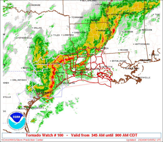
WW 98 TORNADO LA TX CW 291910Z - 300200Z


URGENT - IMMEDIATE BROADCAST REQUESTED
Tornado Watch Number 98
NWS Storm Prediction Center Norman OK
210 PM CDT Wed Mar 29 2017

The NWS Storm Prediction Center has issued a

* Tornado Watch for portions of
Western Louisiana
Southeast Texas
Coastal Waters

* Effective this Wednesday afternoon and evening from 210 PM
until 900 PM CDT.

* Primary threats include...
A couple tornadoes possible
Isolated very large hail events to 2 inches in diameter possible
Isolated damaging wind gusts to 70 mph possible

SUMMARY...The environment across the region continues to become
increasingly favorable for a severe risk including the possibility
of a couple of tornadoes. Storms should continue to gradually
increase and expand northeastward through the late afternoon and
evening hours.

The tornado watch area is approximately along and 60 statute miles
north and south of a line from 45 miles north northwest of Galveston
TX to 30 miles east southeast of Fort Polk LA. For a complete
depiction of the watch see the associated watch outline update
(WOUS64 KWNS WOU8).

PRECAUTIONARY/PREPAREDNESS ACTIONS...

REMEMBER...A Tornado Watch means conditions are favorable for
tornadoes and severe thunderstorms in and close to the watch
area. Persons in these areas should be on the lookout for
threatening weather conditions and listen for later statements
and possible warnings.

&&

AVIATION...Tornadoes and a few severe thunderstorms with hail
surface and aloft to 2 inches. Extreme turbulence and surface wind
gusts to 60 knots. A few cumulonimbi with maximum tops to 550. Mean
storm motion vector 24025.

...Guyer


Read more

For additional SPC information click here
 

WesL

"Bill, I'm talkin' imminent rueage"
Staff member
Administrator
Moderator
Sustaining Member
Messages
3,344
Reaction score
2,614
Location
Fayetteville, AR
Special Affiliations
  1. SKYWARN® Volunteer
Thanks for hanging with us. TWBot really like playing with fire, as you can see. Going to tweak the settings a bit and try again. Going to narrow it down to watches and MD's for the moment.

As I tweak the settings you are more than likely going to see some duplicate posts. I'll delete them as soon as I get back in the thread.
 

KoD

Moderator
Staff member
Moderator
PerryW Project Supporter
Messages
1,380
Reaction score
697
Location
Huntsville, AL
Love the bender avatar.

The two T-warned Texas cells have nice rotation. Looks like some substantial hail too
 

WesL

"Bill, I'm talkin' imminent rueage"
Staff member
Administrator
Moderator
Sustaining Member
Messages
3,344
Reaction score
2,614
Location
Fayetteville, AR
Special Affiliations
  1. SKYWARN® Volunteer
Love the bender avatar.

The two T-warned Texas cells have nice rotation. Looks like some substantial hail too
I felt TWBot was deserving of it.

Nice and bright on radar. Looks like some damage behind it.
upload_2017-3-29_16-1-53.png
 

TWBot

TalkWeather Bot
Don't Feed The Bots
Messages
542
Reaction score
2
Location
On a server
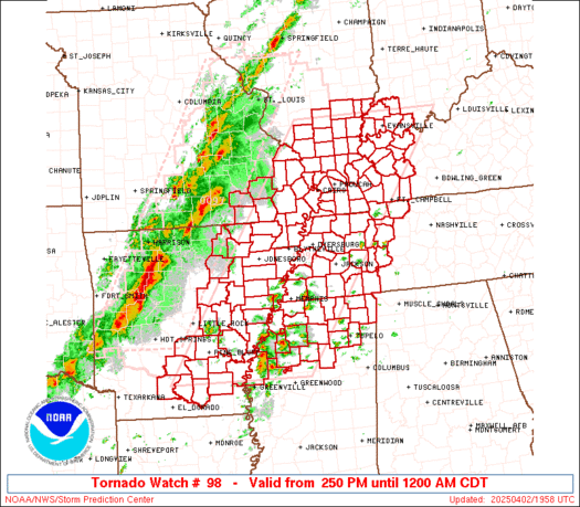
WW 99 TORNADO KS MO 292050Z - 300400Z


URGENT - IMMEDIATE BROADCAST REQUESTED
Tornado Watch Number 99
NWS Storm Prediction Center Norman OK
350 PM CDT Wed Mar 29 2017

The NWS Storm Prediction Center has issued a

* Tornado Watch for portions of
Eastern Kansas
Western and south-central Missouri

* Effective this Wednesday afternoon and evening from 350 PM
until 1100 PM CDT.

* Primary threats include...
A few tornadoes and a couple intense tornadoes possible
Scattered large hail and isolated very large hail events to 2
inches in diameter possible
Isolated damaging wind gusts to 70 mph possible

SUMMARY...The air mass continues to gradually destabilize to the
east of a surface low and along/south of a northward-spreading warm
front across eastern Kansas and western Missouri. Severe hail may be
the most common risk initially. With time, a tornado risk may
increase particularly across parts of western/southern Missouri
where damaging winds will also be a concern.

The tornado watch area is approximately along and 75 statute miles
east and west of a line from 10 miles east northeast of Olathe KS to
50 miles south southeast of Springfield MO. For a complete depiction
of the watch see the associated watch outline update (WOUS64 KWNS
WOU9).

PRECAUTIONARY/PREPAREDNESS ACTIONS...

REMEMBER...A Tornado Watch means conditions are favorable for
tornadoes and severe thunderstorms in and close to the watch
area. Persons in these areas should be on the lookout for
threatening weather conditions and listen for later statements
and possible warnings.

&&

OTHER WATCH INFORMATION...CONTINUE...WW 98...

AVIATION...Tornadoes and a few severe thunderstorms with hail
surface and aloft to 2 inches. Extreme turbulence and surface wind
gusts to 60 knots. A few cumulonimbi with maximum tops to 500. Mean
storm motion vector 20035.

...Guyer


Read more

Continue reading...
 

TWBot

TalkWeather Bot
Don't Feed The Bots
Messages
542
Reaction score
2
Location
On a server
WW 100 TORNADO AR OK TX 292120Z - 300500Z


URGENT - IMMEDIATE BROADCAST REQUESTED
Tornado Watch Number 100
NWS Storm Prediction Center Norman OK
420 PM CDT Wed Mar 29 2017

The NWS Storm Prediction Center has issued a

* Tornado Watch for portions of
Western and northern Arkansas
Far eastern Oklahoma
Far northeast Texas

* Effective this Wednesday afternoon from 420 PM until Midnight
CDT.

* Primary threats include...
A couple tornadoes possible
Isolated very large hail events to 2 inches in diameter possible
Isolated damaging wind gusts to 70 mph possible

SUMMARY...Increasing convection currently focused across western
Arkansas should continue to intensify through the remainder of the
afternoon into this evening. Some severe hail will initially be
possible, with an early-evening increase of low-level shear
supportive of a tornado/damaging wind risk as well.

The tornado watch area is approximately along and 60 statute miles
east and west of a line from 15 miles north northeast of Harrison AR
to 30 miles south southwest of Texarkana AR. For a complete
depiction of the watch see the associated watch outline update
(WOUS64 KWNS WOU0).

PRECAUTIONARY/PREPAREDNESS ACTIONS...

REMEMBER...A Tornado Watch means conditions are favorable for
tornadoes and severe thunderstorms in and close to the watch
area. Persons in these areas should be on the lookout for
threatening weather conditions and listen for later statements
and possible warnings.

&&

OTHER WATCH INFORMATION...CONTINUE...WW 98...WW 99...

AVIATION...Tornadoes and a few severe thunderstorms with hail
surface and aloft to 2 inches. Extreme turbulence and surface wind
gusts to 60 knots. A few cumulonimbi with maximum tops to 500. Mean
storm motion vector 23035.

...Guyer


Read more

Continue reading...
 

warneagle

Member
Messages
3,729
Reaction score
3,208
Location
Arlington, VA
Special Affiliations
  1. SKYWARN® Volunteer
Strong couplet southeast of Jasper.
 

Attachments

  • IMG_7336.PNG
    IMG_7336.PNG
    306.4 KB · Views: 7
X

Xenesthis

Guest
Ok concerning tomorrow's threat here are my current thoughts.. Granted small scale issues could completely bust this but here is why I am seeing a major tornado outbreak for tomorrow. The NAM is showing zero convection on the gulf coast which is makes me feel confident that the flow won't be cut off. The NAM is pretty reliable as well. I also expect to see the risk area expanded and/or increased! My areas of primary concern are Ne MS, Nw AL, and all of middle TN! I am expecting a few long track intense tornadoes as well. I believe this is the storm that my data was pointing to months ago. Time will tell but it fits my March 23rd-April 3rd time line. We will see I expect quite a show!
 

Bama Ravens

Member
Messages
1,207
Reaction score
648
Location
Morris, AL (Northern Jefferson County)
Ok concerning tomorrow's threat here are my current thoughts.. Granted small scale issues could completely bust this but here is why I am seeing a major tornado outbreak for tomorrow. The NAM is showing zero convection on the gulf coast which is makes me feel confident that the flow won't be cut off. The NAM is pretty reliable as well. I also expect to see the risk area expanded and/or increased! My areas of primary concern are Ne MS, Nw AL, and all of middle TN! I am expecting a few long track intense tornadoes as well. I believe this is the storm that my data was pointing to months ago. Time will tell but it fits my March 23rd-April 3rd time line. We will see I expect quite a show!
Chill man, I think you're going a little overboard here.
 
Back
Top