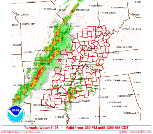
SPC 1630Z Day 1 Outlook

Day 1 Convective Outlook
NWS Storm Prediction Center Norman OK
1147 AM CDT Wed Mar 29 2017
Valid 291630Z - 301200Z
...THERE IS AN ENHANCED RISK OF SEVERE THUNDERSTORMS FROM THE
OZARKS/LOWER MO VALLEY SOUTHWARD TO LA/LOWER MS RIVER VALLEY...
...THERE IS A SLIGHT RISK OF SEVERE THUNDERSTORMS FROM THE
OZARKS/LOWER MO VALLEY SOUTHWARD TO LA/LOWER MS RIVER VALLEY...
...THERE IS A MARGINAL RISK OF SEVERE THUNDERSTORMS FROM EAST
TX/SOUTH-CENTRAL PLAINS TO MS RIVER VALLEY...
...SUMMARY...
Severe thunderstorms are expected later today into tonight from
parts of east Texas, eastern Oklahoma, and southeast Kansas into the
lower and middle Mississippi Valley. Large hail, tornadoes, and
damaging winds will be possible especially late this afternoon and
tonight.
...Ozarks/lower MO Valley to ArkLaTex/lower MS River Valley...
The closed upper trough currently over the south-central Plains at
late morning will continue a slow-general-northeastward advance
toward the lower MO River Valley through late tonight and early
Thursday. Ahead of this system, 12Z regional observed soundings
reflected considerable lapse-rate-related impacts from the
overnight/early morning squall line that continues to move generally
east-northeastward and decay across the Ozarks and Ark-La-Tex
vicinity. This may have ramifications on the
extensiveness/likelihood of significant hail potential, for
instance, although the air mass will recover/gradually moisten and
destabilize to the south of a northward-moving warm front across the
Ozarks/lower MO Valley, and ahead (east) of a slow-eastward-moving
cold front.
Latest thinking is that surface-based storms will develop as early
as mid-afternoon near the eastern KS surface low southward along the
front, including far eastern portions of KS/OK into western portions
of MO/AR. Moderate low-level hodograph curvature (beneath strong but
somewhat backed mid-level southwesterly winds) and resultant strong
low-level shear/SRH will support a tornado risk aside from large
hail and evolving damaging wind risk into this evening.
Farther south, storms may diurnally be a bit more isolated across
the remainder of the ArkLaTex vicinity, although an ongoing
quasi-linear cluster across near-coastal southeast TX may persist
east-northeastward into LA as it favors a zone of outflow-related
weak boundary/zone of differential heating. This cluster and other
peripheral development may pose a damaging wind/tornado risk through
the afternoon and evening hours.
Later tonight, storms should increase in coverage/intensity
initially across portions of AR/LA as forcing for ascent/DPVA
increases related to an east/northeastward-ejecting vorticity maxima
within the base of the larger-scale trough. Related mass response
should result in increasingly strong low-level winds/confluence. A
mixed mode of storms should be prevalent, with hail initially
possible prior to a more common damaging wind/embedded tornado risk
as storms toward/across the MS River late tonight.
..Guyer.. 03/29/2017
Read more
For additional SPC information click here