• Welcome to TalkWeather!
    We see you lurking around TalkWeather! Take the extra step and join us today to view attachments, see less ads and maybe even join the discussion.
    CLICK TO JOIN TALKWEATHER

Severe WX Severe Weather 4/24-4/26

Very concerning amplification trend on the GFS.

GFS operational 500mb

IMG-0593.gif


GFS ensemble mean 500mb

IMG-0594.gif


The parameter space on a large number of GFS ensembles is absurd.
 
Very concerning amplification trend on the GFS.

GFS operational 500mb

IMG-0593.gif


GFS ensemble mean 500mb

IMG-0594.gif


The parameter space on a large number of GFS ensembles is absurd.
As a result, big time downtrend on 4/26 and a big time uptrend on 4/27. We shall see if this is mirrored in the rest of the 00z suite. Legit 1974 OWS here:

 
Every 00z model in so far shows potential for a significant, widespread severe outbreak on Monday across the Mid South and OV, perhaps extending north to the S Great Lakes. Synoptic pattern is favoring supercells as well given the relatively low amplitude of the parent trough and large EML plume.
 
Area Forecast Discussion
National Weather Service Memphis TN
1153 PM CDT Wed Apr 22 2026

.....................................Edited
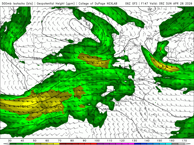
On Monday morning, a stronger upper jet streak will have
propagated into the Southern Plains from within the subtropical
jet with strong ensemble support. Phasing with the polar trough
to the north, this system will amplify as it continues east
towards the Mid-South. A surface low will then deepen across the
Midwest in response with a Pacific cold front extending south.
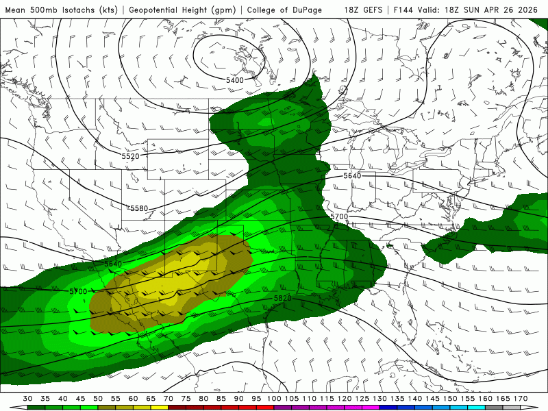
Multiple days of antecedent, southerly advection will bring dew
points in the upper 60s to low 70s as far north as the Ohio
River, occupying the majority of the Mid-South. The latest LREF
guidance paints a telling picture of this type of parameter space
with a 70% - 80% chance of 1500+ J/kg SBCAPE and 40+ knots of
bulk shear Monday afternoon and evening over the majority of the
region. This is a huge signal for severe weather, especially at 4-
5 days out and signifies that Monday is likely to be a day to
look out for.
However, it does still appear too early to tell
exactly which severe hazards will be most likely as models have
yet to converge on key features such as the position of the
surface low and potency of the low level jet. Regardless, the
overlap of CAPE and shear does at least highlight the risk for
severe wind and hail. Following this trend SPC has maintained the
Slight (level 2/5) Risk for Monday as of last night.
 
0z UKmet for Monday from synoptics to mesoscale is downright apocalyptic. Almost the entire warm sector from Dixie alley to the upper Midwest has cape values above 4000 with helicity values above 300, exceeding 500 even.
But honestly, every single global model shows a disgustingly large warm sector with similar volatile kinematics.
You have a low amplitude longwave trough with an embedded leading shortwave which leads to a sub 990mb surface low that draws in 70s dew points almost right up into its core.
Surface winds are also backed throughout the middle to forward portions of the entire warm sector, with deep layer flow orthogonal relative to those winds as well.
Most alarming for me is that every global model also shows a 500mb jet streak velocity of 70+knots superimposed right over the upper Midwest.
Combine that with a 40 to 50+ knot LLJ that’s present throughout the entire day and you’re looking, at least at this point, the most favorable setup for a regional tornado outbreak since March 31/April 1, 2023.
Hopefully things begin to downtrend during the next 4 days leading up.
 
Last edited:
Look for SPC to start highlight two areas Monday situation . Threat now highlighted and another area south of that for super cells structure s. More a tornado threat .models just keep up trending this were soon going be in a long track tornado environment, if not already…
 
Last edited:
Well guys, took this sounding from the GFS around the SW portion of IL, and the only analog that shows up is none other than the 1999 Bridge Creek-Moore EF5 tornado. Buckle up.


In case the image doesn't load (because images on this website are still broken), the analog reads 03 May 99 23Z (OKC) SIG with a SARS 70% match.
 
Something VERY interesting is the disagreement between CSU models and the SPC for Monday in terms of area of most interest. CSU points out the Tennessee Valley to Memphis as the area of greatest concern, while the SPC has moved it up to the Midwest again, around Illinois and Missouri.

That’s why I think when all said done we will be seeing two areas being outlined highest risk … really think risk they have now is will see
More damaging wind threat. Greater forcing furthet
North Monday
 

Quiet on that thread for today
 
Well guys, took this sounding from the GFS around the SW portion of IL, and the only analog that shows up is none other than the 1999 Bridge Creek-Moore EF5 tornado. Buckle up.


In case the image doesn't load (because images on this website are still broken), the analog reads 03 May 99 23Z (OKC) SIG with a SARS 70% match.

I believe that analog popped up a couple days out from the mon/tue threat last week, so I'm cautiously hoping that the comparison doesn't ring true this time.
 
Back
Top