WhirlingWx
Member
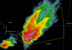
Surface Obs from SPC Mesoanalysis show 79/65 at Pontiac which is certainly a spread (not insurmountable, but could explain some of those issues).I'm looking at several chaser livestreams that are on the Pontiac storm, and from both looking at and listening to chaser commentary, the cell in question seems to be having trouble with a fairly high cloud base.
EDIT: Well, at least they showed. The page refreshed as soon as I typed this and now shows 68/64 with winds out of the northwest which is goofy. Probably because of outflow from the storm itself. Meanwhile, Kankakee now says 70/64 with winds out of the SE.