• Welcome to TalkWeather!
    We see you lurking around TalkWeather! Take the extra step and join us today to view attachments, see less ads and maybe even join the discussion.
    CLICK TO JOIN TALKWEATHER

Severe Weather 2026

Observed tor in S TX from some sort of remnants low.

Funny thing is I was looking at that area this morning for a tor or two and was gonna have a dare at mentioning it but seemed a bit too conditional to call. Wish I had now.
 
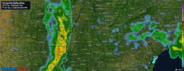
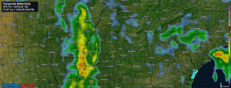
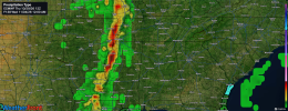
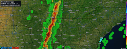
One thing I'm seeing on both the 18z GFS as well as 12z Euro that makes me question next week's severe weather risk is how slow the squall line is. Like when looking at 18z GFS, the line hardly moves between 3pm to 6pm Tuesday. 12z Euro is even slower bringing it into North MS late Tuesday night/early Wednesday morning. However, both solutions would have a damaging wind risk and low end tornado risk. 12z Euro would have a better severe threat than GFS.
 

Attachments

  • WeatherFront_GFS_REFC_F123_2026-11-03_0300_PM.png
    WeatherFront_GFS_REFC_F123_2026-11-03_0300_PM.png
    7.3 MB · Views: 3
  • WeatherFront_GFS_REFC_F126_2026-11-03_0600_PM.png
    WeatherFront_GFS_REFC_F126_2026-11-03_0600_PM.png
    7.3 MB · Views: 2
  • WeatherFront_ECMWF_PTYPE_F138_2026-11-04_1200_AM.png
    WeatherFront_ECMWF_PTYPE_F138_2026-11-04_1200_AM.png
    7.1 MB · Views: 3
  • WeatherFront_ECMWF_PTYPE_F141_2026-11-04_0300_AM.png
    WeatherFront_ECMWF_PTYPE_F141_2026-11-04_0300_AM.png
    7.1 MB · Views: 4
One thing I'm seeing on both the 18z GFS as well as 12z Euro that makes me question next week's severe weather risk is how slow the squall line is. Like when looking at 18z GFS, the line hardly moves between 3pm to 6pm Tuesday. 12z Euro is even slower bringing it into North MS late Tuesday night/early Wednesday morning. However, both solutions would have a damaging wind risk and low end tornado risk. 12z Euro would have a better severe threat than GFS.
To be fair, the globals are pretty notorious for depicting convection wayyyy slower than it ends up being, but we're also still in the time range where the synoptic level stuff can slow down or speed up, so who knows. If it really is a slow-moving QLCS system, also brings into question how much of the convection is actually in a zone favorable for severe, and for how long.
 
To be fair, the globals are pretty notorious for depicting convection wayyyy slower than it ends up being, but we're also still in the time range where the synoptic level stuff can slow down or speed up, so who knows. If it really is a slow-moving QLCS system, also brings into question how much of the convection is actually in a zone favorable for severe, and for how long.
Right. which is why I'm more wary of a heavy rain/flash flood risk than I am the severe threat at this time. The SPC even hints at the slowness potential of this system in the Day 4-8 outlook.
 
Back
Top