• Welcome to TalkWeather!
    We see you lurking around TalkWeather! Take the extra step and join us today to view attachments, see less ads and maybe even join the discussion.
    CLICK TO JOIN TALKWEATHER

Severe Weather 2026

Observed tor in S TX from some sort of remnants low.

Funny thing is I was looking at that area this morning for a tor or two and was gonna have a dare at mentioning it but seemed a bit too conditional to call. Wish I had now.
 
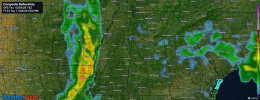
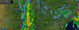
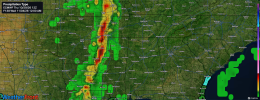
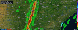
One thing I'm seeing on both the 18z GFS as well as 12z Euro that makes me question next week's severe weather risk is how slow the squall line is. Like when looking at 18z GFS, the line hardly moves between 3pm to 6pm Tuesday. 12z Euro is even slower bringing it into North MS late Tuesday night/early Wednesday morning. However, both solutions would have a damaging wind risk and low end tornado risk. 12z Euro would have a better severe threat than GFS.
 

Attachments

  • WeatherFront_GFS_REFC_F123_2026-11-03_0300_PM.png
    WeatherFront_GFS_REFC_F123_2026-11-03_0300_PM.png
    7.3 MB · Views: 6
  • WeatherFront_GFS_REFC_F126_2026-11-03_0600_PM.png
    WeatherFront_GFS_REFC_F126_2026-11-03_0600_PM.png
    7.3 MB · Views: 3
  • WeatherFront_ECMWF_PTYPE_F138_2026-11-04_1200_AM.png
    WeatherFront_ECMWF_PTYPE_F138_2026-11-04_1200_AM.png
    7.1 MB · Views: 5
  • WeatherFront_ECMWF_PTYPE_F141_2026-11-04_0300_AM.png
    WeatherFront_ECMWF_PTYPE_F141_2026-11-04_0300_AM.png
    7.1 MB · Views: 8
One thing I'm seeing on both the 18z GFS as well as 12z Euro that makes me question next week's severe weather risk is how slow the squall line is. Like when looking at 18z GFS, the line hardly moves between 3pm to 6pm Tuesday. 12z Euro is even slower bringing it into North MS late Tuesday night/early Wednesday morning. However, both solutions would have a damaging wind risk and low end tornado risk. 12z Euro would have a better severe threat than GFS.
To be fair, the globals are pretty notorious for depicting convection wayyyy slower than it ends up being, but we're also still in the time range where the synoptic level stuff can slow down or speed up, so who knows. If it really is a slow-moving QLCS system, also brings into question how much of the convection is actually in a zone favorable for severe, and for how long.
 
To be fair, the globals are pretty notorious for depicting convection wayyyy slower than it ends up being, but we're also still in the time range where the synoptic level stuff can slow down or speed up, so who knows. If it really is a slow-moving QLCS system, also brings into question how much of the convection is actually in a zone favorable for severe, and for how long.
Right. which is why I'm more wary of a heavy rain/flash flood risk than I am the severe threat at this time. The SPC even hints at the slowness potential of this system in the Day 4-8 outlook.
 
new day 4

A large positive-tilt upper trough will move into the Plains on Monday/D4, with a surface low moving from the central Plains into the Upper MS Valley. A substantial low-level moisture plume with mid 60s F dewpoints will spread north ahead of the developing low and cold front, aided by 40+ kt south/southwest 850 mb winds. The main severe threat should develop during the afternoon along the cold front, where MUCAPE on the order of 1000 J/kg will be likely. Effective deep-layer shear will be near 50 kt, with sufficient low-level turning with height to support both supercells and linear structures late. Damaging winds and perhaps a couple tornadoes will be possible, with sporadic large hail as well
 

Attachments

  • day4prob.gif
    day4prob.gif
    27.4 KB · Views: 5
new day 4

A large positive-tilt upper trough will move into the Plains on Monday/D4, with a surface low moving from the central Plains into the Upper MS Valley. A substantial low-level moisture plume with mid 60s F dewpoints will spread north ahead of the developing low and cold front, aided by 40+ kt south/southwest 850 mb winds. The main severe threat should develop during the afternoon along the cold front, where MUCAPE on the order of 1000 J/kg will be likely. Effective deep-layer shear will be near 50 kt, with sufficient low-level turning with height to support both supercells and linear structures late. Damaging winds and perhaps a couple tornadoes will be possible, with sporadic large hail as well
hmmmm November second season tease..
 
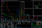
HRRR decided to pull this up for Sunday in SW AZ. Severe weather season ain't done. hrrr_2026103100_045_32.44--113.58.png

That's the type of broad, vague headline you'd probably get elsewhere but it is important to note the failure modes in such a profile for Arizona. The wind profile literally backing in itself at 2km-3km and notable dry air entrainment/subsidence throughout the profile.

Do think a tornado or two is possible given strong forcing could establish convection, perhaps more mini in nature however. A seemingly unrelenting period of severe weather for Arizona picks back up and this is the same trough that establishes our severe threat on Monday in Oklahoma too.
 
HRRR decided to pull this up for Sunday in SW AZ. Severe weather season ain't done. View attachment 55455

That's the type of broad, vague headline you'd probably get elsewhere but it is important to note the failure modes in such a profile for Arizona. The wind profile literally backing in itself at 2km-3km and notable dry air entrainment/subsidence throughout the profile.

Do think a tornado or two is possible given strong forcing could establish convection, perhaps more mini in nature however. A seemingly unrelenting period of severe weather for Arizona picks back up and this is the same trough that establishes our severe threat on Monday in Oklahoma too.
Insane Arizona has had more rain and storms then the “dreary “ midatlantic here.


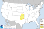
...THERE IS A SLIGHT RISK OF SEVERE THUNDERSTORMS OVER PARTS OF
NORTHERN TEXAS...AND FROM WESTERN AND CENTRAL OKLAHOMA INTO
SOUTHEAST KANSAS...

..SUMMARY


SCATTERED SEVERE STORMS MAY DEVELOP ACROSS PARTS OF THE CENTRAL TO
SOUTHERN PLAINS MONDAY FROM LATE AFTERNOON INTO THE EVENING, WITH
DAMAGING WIND GUSTS THE MAIN THREAT.

..DISCUSSION


ON MONDAY, A LARGE UPPER TROUGH WILL CROSS THE ROCKIES AND MOVE INTO
THE PLAINS, WITH THE UPPER LOW MOVING FROM CO INTO KS. A LEADING
WAVE WILL MOVE OUT OF THE SOUTHERN HIGH PLAINS AND INTO OK/KS DURING
THE DAY, WHILE THE SECONDARY AND STRONGER WAVE MOVES EASTWARD OUT OF
NORTHERN NM.

AT THE SURFACE, LOW PRESSURE WILL BE PRESENT OVER THE CENTRAL HIGH
PLAINS MONDAY MORNING, AND THIS WILL DEEPEN INTO NE BY 00Z. A COLD
FRONT WILL EXTEND SOUTHWESTWARD FROM THE LOW, MOVING SOUTHWARD
ACROSS CO AND WESTERN KS DURING THE DAY. ANOTHER FRONT/DRYLINE WILL
EXTEND SOUTH ACROSS CENTRAL KS, WESTERN OK, AND WESTERN TX THROUGH
00Z, AND THIS BOUNDARY WILL PUSH EAST OVERNIGHT AS THE NM
DISTURBANCE PROCEEDS EASTWARD.

WHILE AMPLE DEEP-LAYER SHEAR AND A BROAD FETCH OF 60S F DEWPOINTS
WILL EXIST OVER THE CENTRAL AND SOUTHERN PLAINS, SURFACE HEATING
WILL BE LIMITED OVER MUCH OF THE AREA, AND LIKELY RELEGATED TO THE
DRYLINE. FORECAST SOUNDINGS INDICATE A RELATIVELY COOL BUT MOIST
BOUNDARY LAYER EAST OF THE DRYLINE DURING THE DAY, WITH A MINOR
CAPPING INVERSION ABOVE 850 MB WHICH SHOULD PREVENT WARM SECTOR
STORMS AWAY FROM THE DRYLINE/FRONT.

IT IS THEREFORE ANTICIPATED THAT THE SEVERE RISK WILL BEGIN NEAR OR
JUST AFTER 00Z OVER WESTERN OK AND PERHAPS NORTHWEST TX, WITH
INCREASING STORM COVERAGE THROUGH THE EVENING AS ACTIVITY SPREADS
ACROSS OK, EASTERN KS, AND PARTS OF NORTHERN TX. MORE ISOLATED
ACTIVITY WILL ALSO BE POSSIBLE ALONG THE DRYLINE TOWARD THE RIO
GRANDE.

STORMS SHOULD INITIATE NEAR THE DRYLINE/WIND SHIFT WHERE UPPER 70S F
TEMPERATURES ARE EXPECTED, REDUCING INHIBITION. AMPLE TURNING WITH
HEIGHT OF THE WIND FIELDS AS WELL AS UP TO A 50 KT LOW-LEVEL JET
WILL SUPPORT STORM ROTATION, WHETHER DISCRETE OR FORMING INTO A
LINE. INSTABILITY WILL NOT BE PARTICULARLY STRONG, BUT SUFFICIENT TO
SUPPORT WIND DAMAGE, AND PERHAPS A TORNADO RISK BETWEEN 00-06Z.

..JEWELL.. 10/31/2026
 
Back
Top