• Welcome to TalkWeather!
    We see you lurking around TalkWeather! Take the extra step and join us today to view attachments, see less ads and maybe even join the discussion.
    CLICK TO JOIN TALKWEATHER

Severe Weather 2026

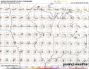
Stupid cap, otherwise Tuesday and several other days this coming week would look great on the GFS in the Midwest.
I think the Midwest needs a break.

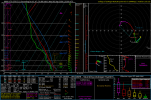
But we're watching Wednesday closely. I'm aware this sounding isn't great OMEGA-wise but this is a look you rarely ever see in the NE. Sounding from Northern PA. Storms initiate in this environment and appear to maintain discreteness somewhat. I'm aware this sounding does exhibit dry air throughout the parcel, albeit it is subtle but ventilation would be good enough for any discrete supercell still in this case. What's the issue?

Lapse rates. But I have generally learned to not really care about lapse rates. They only matter in cases with rather meager forcing, take 12/28/24 as a example with confluence bands that couldn't mature due to lack of strong forcing or even that Arkansas moderate risk after Lake City day last year. Storms were a bit too discrete but struggled with dry air and lapse rates. Lapse rates are big in the NE, but low level shear isn't a pushover in this one. Plus morning convection will be watched.
 

Attachments

  • 2026082906_GFS_111_41.47,-76.89_severe_ml.png
    2026082906_GFS_111_41.47,-76.89_severe_ml.png
    101 KB · Views: 9
I think the Midwest needs a break.

But we're watching Wednesday closely. I'm aware this sounding isn't great OMEGA-wise but this is a look you rarely ever see in the NE. Sounding from Northern PA. Storms initiate in this environment and appear to maintain discreteness somewhat. I'm aware this sounding does exhibit dry air throughout the parcel, albeit it is subtle but ventilation would be good enough for any discrete supercell still in this case. What's the issue?

Lapse rates. But I have generally learned to not really care about lapse rates. They only matter in cases with rather meager forcing, take 12/28/24 as a example with confluence bands that couldn't mature due to lack of strong forcing or even that Arkansas moderate risk after Lake City day last year. Storms were a bit too discrete but struggled with dry air and lapse rates. Lapse rates are big in the NE, but low level shear isn't a pushover in this one. Plus morning convection will be watched.
didn’t realize what we were dealing with till I saw the “PDS tornado” wording. Let’s see what 2026 continues to have in store.
 
Gonna be watching this one. PA and by extention the northeast in general hasnt really had an environment forcasted like this since I believe the 2000s.
Find it hard to believe there hasn't been at least one day to feature this environment. I'll check CIPS analogs out.

didn’t realize what we were dealing with till I saw the “PDS tornado” wording. Let’s see what 2026 continues to have in store.
PDS tor on a sounding is not what you should be necessarily paying attention to. Thermodynamics and shear. If you have a good judgement of both factors, you can discern your own hazard type expectation.
 
Back
Top