WeathermanLeprechaun
Member
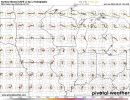
I think the Midwest needs a break.Stupid cap, otherwise Tuesday and several other days this coming week would look great on the GFS in the Midwest.
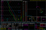
But we're watching Wednesday closely. I'm aware this sounding isn't great OMEGA-wise but this is a look you rarely ever see in the NE. Sounding from Northern PA. Storms initiate in this environment and appear to maintain discreteness somewhat. I'm aware this sounding does exhibit dry air throughout the parcel, albeit it is subtle but ventilation would be good enough for any discrete supercell still in this case. What's the issue?
Lapse rates. But I have generally learned to not really care about lapse rates. They only matter in cases with rather meager forcing, take 12/28/24 as a example with confluence bands that couldn't mature due to lack of strong forcing or even that Arkansas moderate risk after Lake City day last year. Storms were a bit too discrete but struggled with dry air and lapse rates. Lapse rates are big in the NE, but low level shear isn't a pushover in this one. Plus morning convection will be watched.