• Welcome to TalkWeather!
    We see you lurking around TalkWeather! Take the extra step and join us today to view attachments, see less ads and maybe even join the discussion.
    CLICK TO JOIN TALKWEATHER

Severe Weather 2026

Next Tuesday and Wednesday -

On Tuesday, model forecasts are in general agreement, moving an
upper-level trough northeastward into the southern High Plains. An
associated mid-level jet is forecast to eject northeastward ahead of
the system. Model forecasts suggest that the airmass ahead of the
trough will become moderately unstable by Tuesday afternoon. This
combined with strong large-scale ascent should support scattered
severe storms in the afternoon and evening. The favored severe
threat area is expected from parts of the southern and central
Plains eastward into the Ozarks.

On Wednesday, the upper-level trough is forecast to move across the
south-central U.S., as a cold front advances eastward into the
Southeast. A severe threat may again develop Wednesday afternoon as
the airmass ahead of the front becomes unstable. However, there is
considerable model spread concerning the timing of features at this
extended range.


1772633448769.png
 
Dropping in to post the spooky scary map. *plop*
1772639264935.png
Jokes aside, the reason there's so much red is 1) CFS is CFS, it will look completely different by tomorrow, 2) I do think that this active period will continue through the end of March, as this map is for March 18-24. Even before this period, the mid-to-long-range modelling is pretty interested in 3/10-3/12, which has been on our radar for a little while now. I still think it's way too early to get excited about anything in particular, with even this 3/10-3/12 set of disturbances being all over the place, but it's pretty clear we're in for an active March.
1772639337544.png1772639343693.png
1772639642622.png1772639664303.png
 
Dropping in to post the spooky scary map. *plop*
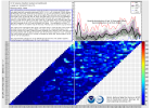
View attachment 50950
Jokes aside, the reason there's so much red is 1) CFS is CFS, it will look completely different by tomorrow, 2) I do think that this active period will continue through the end of March, as this map is for March 18-24. Even before this period, the mid-to-long-range modelling is pretty interested in 3/10-3/12, which has been on our radar for a little while now. I still think it's way too early to get excited about anything in particular, with even this 3/10-3/12 set of disturbances being all over the place, but it's pretty clear we're in for an active March.
View attachment 50951View attachment 50952
View attachment 50953View attachment 50954
Tell you severe wx may have got off to a fast start , but its sure has been quiet n boring Dixie and Midsouth regions thus far. . Im chomping at the bit get things going for some chasing
 
Been quiet so far this year around the ATL area… had a few rumbles of thunder the other week but nothing significant in at least a month. Overseas thru the end of this week but hoping things kick up a notch when I’m back on Monday! Ready to hear some thunder again!
 
Looking ahead… can’t post pics apparently but day 5 and day 6.


..DAY 5/TUESDAY INTO DAY 6/WEDNESDAY


AN UPPER LOW AND ATTENDANT SHORTWAVE TROUGH OVER NORTHWEST MEXICO IS
FORECAST TO EJECT EASTWARD TOWARD THE SOUTHERN HIGH PLAINS ON
TUESDAY. AT THE SAME TIME, A BROAD UPPER TROUGH WITHIN NORTHERN
STREAM FLOW WILL DEVELOP EAST FROM THE NORTHERN PLAINS TO THE UPPER
MIDWEST. AS THIS OCCURS, A BELT OF ENHANCED SOUTHWESTERLY FLOW ALOFT
WILL OVERSPREAD A LARGE WARM/MOIST SECTOR FROM THE SOUTHERN PLAINS
TO THE MID/LOWER MS AND OHIO VALLEYS. A COMPLEX SURFACE PATTERN IS
EXPECTED TO EMERGE, INFLUENCED BY THE SPLIT-FLOW UPPER TROUGHING
PATTERN. A BAROCLINIC ZONE EXTENDING FROM OK TO THE MID-MS VALLEY
AREA WILL BE ONE FOCUS FOR SEVERE THUNDERSTORM POTENTIAL. MEANWHILE,
LEE SURFACE TROUGHING ACROSS WEST TX AND A DEVELOPING DRYLINE WILL
BE ANOTHER FOCUS FOR SEVERE STORM DEVELOPMENT. WHILE DETAILS REMAIN
UNCERTAIN, THESE SURFACE FEATURES, COMBINED WITH STRENGTHENING
SOUTHWESTERLY FLOW OVERSPREADING A WARM AND UNSTABLE AIRMASS, WILL
LIKELY FOSTER A BROAD AREA OF SEVERE THUNDERSTORM POTENTIAL FROM THE
SOUTHERN PLAINS INTO THE MIDWEST.

AS THE UPPER TROUGHS FROM DAY 5/TUESDAY CONTINUE EAST ACROSS THE
SOUTHERN PLAINS AND GREAT LAKES ON DAY 6/WEDNESDAY, A COLD FRONT IS
EXPECTED TO DEVELOP SOUTHEAST ACROSS THE OHIO VALLEY INTO EAST
TEXAS. SPREAD AMONG FORECAST GUIDANCE INCREASES DURING THIS TIME,
LEADING TO MORE UNCERTAINTY. HOWEVER, MOST GUIDANCE HAS SOME OVERLAP
OF FAVORABLE LOW-LEVEL MOISTURE AND INSTABILITY WITH STRONGER
MID/UPPER LEVEL FLOW ACROSS PORTIONS OF EAST TX INTO THE LOWER MS
VALLEY. AS A RESULT, A 15 PERCENT AREA HAS BEEN DELINEATED. THIS
AREA MAY NEED TO SHIFT/EXPAND NORTHEAST WITH TIME DEPENDING ON
TRENDS IN MODEL GUIDANCE, BUT CURRENTLY, IT IS UNCERTAIN IF
SUFFICIENT DESTABILIZATION WILL OCCUR FURTHER NORTHEAST, PRECLUDING
SEVERE PROBABILITIES INTO THE TN/OH VALLEYS VICINITY.
 
We have a lot in front of us, so no point in getting too caught up in the long-range stuff, but definitely eyeing another possible wave of severe potential right around the middle of the month. It's lit up the Deep South in some pretty strong contours. I've noticed it's flagged significant tornado potential, albeit low, which catches my eye, especially at this range. I will caveat with the fact that CIPS' long-range modelling seems to have a bias for the Southeast, though I'm not sure why, so this system/systems may also present a threat to the Plains as well. Just something to keep an eye on.
1772906423759.png1772906440698.png1772906456862.png1772906460150.png
 
For the upcoming tornado season, I started a thread of places with 24/7 Digital Weather Networks besides Alabama.

 
Dunno about other models, but it appears that at least the CFS is slowly starting to change its mind on mid to late march being quiet.
 

Attachments

  • Severe Weather Trapezoid.png
    Severe Weather Trapezoid.png
    310.4 KB · Views: 0
I'm wondering if tommrow is going to be a repeat of the hail storm extravaganza we had a couple of weeks ago that messed up pinson. Hrrr definitely has me intrigued for tommrow.
 
Back
Top