• Welcome to TalkWeather!
    We see you lurking around TalkWeather! Take the extra step and join us today to view attachments, see less ads and maybe even join the discussion.
    CLICK TO JOIN TALKWEATHER

Severe Weather 2026

Regarding prefrontal development tomorrow, there is a notable caveat on a few models that has been present. A subtle warm nose in the midst of limited instability. While most models fire prefrontals, is this case of models falsely attributing a warm nose in or are model bias interfering and causing prefrontal/WAA advection to fire? This is the HRW FV3 simref and this is a sounding from the same vicinity in the midst of that UH track. Subtle warm nose exists if you look closely. My thoughts are that we may not see proper prefrontal initiation sustain. It may be more failed attempts similar to the HRW ARW. Not sure if this warm nose is just a red herring but regardless losing confidence on any confluence band attempts tomorrow with this
 

Attachments

  • hrwfv3_2026012412_031_30.55--87.21.png
    hrwfv3_2026012412_031_30.55--87.21.png
    235.2 KB · Views: 0
  • refcmp_uh001h.us_se (1).png
    refcmp_uh001h.us_se (1).png
    346.2 KB · Views: 0
  • refcmp_uh001h.us_se (2).png
    refcmp_uh001h.us_se (2).png
    356.9 KB · Views: 0
The HRRR continues to strengthen the CAD over Georgia. I'm beginning to doubt we'll see much of a tornado threat in the Montgomery, Auburn, and Columbus vicinity. Although the last frame shows a slight uptick in temperatures, we shall see.

trend-hrrr-2026012514-f004.sfct-imp.us_se.gif
 
I personally think robust prefrontal development is out of the question due to factors i mentioned last night

700 mb warm nose and a lack of good meaningful instability to fight that warm nose. The QLCS may pose a conditional significant damaging wind threat and the potential for several weaker tornadoes, which is dependant on line orientation. If line orientation is poorer then damaging wind will be the main risk most likely
 
Tornado Watch forthcoming for parts of Florida, Alabama and Georgia.
Mesoscale Discussion 0057
NWS Storm Prediction Center Norman OK
0955 AM CST Sun Jan 25 2026

Areas affected...southern AL...FL Panhandle...southwest GA

Concerning...Severe potential...Tornado Watch likely

Valid 251555Z - 251800Z

Probability of Watch Issuance...80 percent

SUMMARY...Severe potential will likely increase into early afternoon
with a QLCS and embedded supercells capable of producing damaging
winds and tornadoes. A tornado watch will likely be needed.

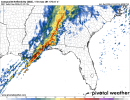
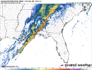
DISCUSSION...Along a pronounced cold front to the south-southwest of
a surface cyclone between TCL and SEM, convective intensities appear
to be increasing to the central Gulf Coast. Pre-frontal cells have
also increased over the past hour, and an increasing severe threat
is anticipated as activity matures over the next 2-3 hours. While
pervasive downstream cloud coverage is limiting boundary-layer
heating in the confined warm-moist sector, 60s surface dew points
are sufficient for weak to modest MLCAPE from Mobile Bay and the
western FL Panhandle northward into south-central AL. This
warm-moist sector will shift east through the afternoon and likely
reach southwest GA to the eastern FL Panhandle. Low-level shear is
quite strong with enlarged hodographs favoring
mesocyclone/mesovortex development. Expectation is for a QLCS to
evolve east through the afternoon with a threat for damaging winds
and brief tornadoes. If semi-discrete supercells can form ahead of
and merge into the QLCS, a longer-tracked tornado or two is
possible.

..Grams/Hart.. 01/25/2026

...Please see www.spc.noaa.gov for graphic product...

ATTN...WFO...FFC...TAE...BMX...MOB...LIX...

LAT...LON 30388857 31858758 32418709 32478584 32218462 32008402
31608382 30688419 29788531 30188614 30388857

MOST PROBABLE PEAK TORNADO INTENSITY...100-130 MPH
MOST PROBABLE PEAK WIND GUST...55-70 MPH
 
Tornado Watch forthcoming for parts of Florida, Alabama and Georgia.

If that portion of the line near Montgomery can break through and make a NE line orientation, tornado chances are certainly there.
 
Brief tornado threat increasing in SW AL/FL Panhandle albeit conditional at the moment. Embedded supercell also may be developing further north additionally near Montgomery. Issues are the low level inversion and is shear enough to rip thru the stable layer?
 
Broad rotation on the storm going over Montgomery now. BMX tagged the SVR as tornado possible.
Yup. So much for my post earlier. :D

BULLETIN - IMMEDIATE BROADCAST REQUESTED
Severe Thunderstorm Warning
National Weather Service Birmingham AL
1124 AM CST Sun Jan 25 2026

The National Weather Service in Birmingham has issued a

* Severe Thunderstorm Warning for...
Southern Elmore County in east central Alabama...
Northwestern Macon County in southeastern Alabama...
South central Tallapoosa County in east central Alabama...
Northern Montgomery County in south central Alabama...

* Until 1215 PM CST.

* At 1124 AM CST, a severe thunderstorm was located over western
Montgomery, moving east at 50 mph.

HAZARD...60 mph wind gusts.

SOURCE...Radar indicated.

IMPACT...Expect damage to roofs, siding, and trees.

* Locations impacted include...
Montgomery, Prattville, Wetumpka, Tallassee, Milstead, Coosada,
Shorter, Franklin, Montgomery Zoo, Boylston, Auburn University In
Montgomery, Bob Woodruff Lake, Reeves Airport, Emerald Mountain,
Maxwell Air Force Base, Waugh, Lagoon Park, Alabama State
University, Tallapoosa City, and Eastdale Mall.

PRECAUTIONARY/PREPAREDNESS ACTIONS...

Remain alert for a possible tornado! Tornadoes can develop quickly
from severe thunderstorms. If you spot a tornado go at once into the
basement or small central room in a sturdy structure.

For your protection move to an interior room on the lowest floor of a
building.

A Tornado Watch remains in effect until 600 PM CST for south central
and southeastern Alabama.

&&

LAT...LON 3228 8636 3244 8639 3268 8579 3235 8580
TIME...MOT...LOC 1724Z 253DEG 41KT 3234 8634

TORNADO...POSSIBLE
HAIL THREAT...RADAR INDICATED
MAX HAIL SIZE...<.75 IN
WIND THREAT...RADAR INDICATED
MAX WIND GUST...60 MPH
 
Back
Top