• Welcome to TalkWeather!
    We see you lurking around TalkWeather! Take the extra step and join us today to view attachments, see less ads and maybe even join the discussion.
    CLICK TO JOIN TALKWEATHER

Severe Weather 2025

Brilliant question!

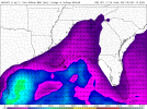
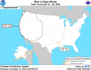
The only notable event was Eowyn. The same system that caused a historic blizzard in the Gulf caused a windstorm that made the whole country go into a status Red warning. That is the HIGHEST we can get. And the whole country being in it was the first time ever. I genuinely felt nervous, and was afraid of severe structural damage with likely 75+ mph gusts slamming our vicinity but we didn't get those intense gusts, the system shifted a bit last minute and thankfully we avoided the worst case scenario. There was a storm just a month before Eowyn that had some very loud gusts, and was a more intense experience than Eowyn. Might make a thread about windstorms actually.....
I remember the windstorm in Ireland and the UK but didn't recall that it was the same system as the one that caused the intense snowfall on the Gulf Coast. Fascinating!
 
A few members here seen Arnett happen too - that would be @CheeselandSkies and @andyhb. I did not think i would end up witnessing a 5/4/07 repeat in terms of the area take place soon that night..

Made a couple of new YouTube "short" timelapses of both main Arnett tornadoes set to music. The first one is similar to the original only slightly longer (incorporating the footage I somehow skipped over when making my original edit), and I tweaked the position tracking on a couple other shots.


Last edited:
Man, what a year this has been.

Considering there doesn't seem to be much of a severe threat today and plausibly for a good while, I thought I'd ask what event this year was the most memorable for you guys? Whether it be a hurricane or a tornado outbreak. Just figured I'd ask as the lull has made things quiet around here.
The most memorable for me personally were March 14-15 and Erin. I ended up missing both Enderlin and the May 18 tornado outbreak, because of course I did (I always have the worst luck for missing classic Plains severe weather events), but they were definitely up there for the year in general.
 
The list of most notable weather events that I covered in 2025 has to start with the Los Angeles fires. That was a generational pyro-event that was unlike anything I’ve witnessed in my lifetime.

The january blizzard along the gulf coast was also very anomalous and significant. I recall having to personally deal with ice melt shortages here in New England because of the emergency shipments down south.

I would also argue that the entire tornado season was upper-echelon in terms of those active years that we like to hold a candle to. Both 2024-2025 combined, it’s been one of the most active pairs of years we’ve seen since perhaps 2010-2011, and 2003-2004. The March 14-15 outbreak was very significant, and I remember the feeling of dread watching those two days unfold live. A couple of those mid-may outbreaks were also highly notable.

The Hurricane season was an afterthought for some, but still memorable for others. In the end, it was a year of relief for many who needed it. And that is all I can say about that.
 
I think March 15th truly had us waiting for the worst and was more a WHEN than an IF. Luckily it wasn’t as bad as what it could’ve been, but still managed to be a violent day. March 14th was overshadowed leading up to those two days but ended being more extreme in terms of tornadoes. The environment on the 15th was probably as close as we’ll get to 4/27 in terms of synoptics before an event (obviously we don’t know what exactly will happen with weather)

The Enderlin EF5 was definitely the highlight of my year and quite frankly a lot of people’s highlight. A lot of us tracked that day and I think when we saw the Spiritwood tornado we knew we’re gonna have trouble. But a very unlikely sequence occurred at the time we didn’t know we were witnessing the first EF5 in 13 years.

London was particularly interesting to me. Given how far it was from any radar. That supercell produced a few other intense tornadoes and was super long-tracked. It was definitely horrible what happeend in-around Somerset and London, but could’ve been a lot worse.
 
Is this signal a quick red herring from the GFS? Could be. I'm surprised at this suddenly decent svr setup that just planted itself over Dixie on the 18th. I took a sounding from Eastern Mississippi. Strong low level shear, good enough instability and decent enough lapse rates. A interesting setup by any means that would certainly favor a tornado threat.

This is the MUCAPE/CINH map. A great way to determine storm mode (Confluence band events being the main exception, I'll show how to detect those in a different setup)

With winds being parallel to the front, the mode would easily be linear but here, they're perpendicular. That means likely discrete storms!

There should be enough instability to carry through with potentially tornadic cells here IF the GFS's thinking stays steady. Rapid uptrend from the GFS but will see if it stays on board. A bit wary of this signal but worth acknowledging in case
 

Attachments

  • 2025121406_GFS_111_31.95,-88.39_winter_mu.png
    2025121406_GFS_111_31.95,-88.39_winter_mu.png
    103.1 KB · Views: 0
  • GFSSE_con_mucape_114.png
    GFSSE_con_mucape_114.png
    125.4 KB · Views: 0
It's only a matter of when and time before we get a significant severe weather outbreak which should be soon because you can't have big pattern change/shift without it.
 
It's only a matter of when and time before we get a significant severe weather outbreak which should be soon because you can't have big pattern change/shift without it.

We're incredibly overdue, which is a good thing in some aspects, but then when it DOES happen (and it will)....well, you get the idea.
 
By D5/Thursday, weak to moderate instability is expected from East
Texas to the Mid-Mississippi Valley. Strong shear will be present
north of I-20 as a mid-level trough amplifies and a strong mid-level
jet overspreads the warm sector. Despite the presence of strong
shear and weak to moderate instability, updraft intensity may still
struggle due to weak lapse rates/warm air aloft. Only weak height
falls/cooling temperatures aloft are forecast south of the MO
Bootheel. Thunderstorms are likely from the Mid-Mississippi Valley
northward, where forcing will be stronger, but these regions will
remain well north of the more favorable instability. Therefore, any
severe weather threat would likely be marginal.

Marginal. We know that can change. Not saying it will, but wouldn't be the first time.
 
Latest GFS does weaken mid level lapse rates and a more stout warm nose aloft. Could ring similar to the event one or two weeks ago in Alabama where updrafts struggled to get going due to poor lapse rates. We have the shear in place for tornadoes, but any discrete updraft would struggle unless they get mergers. Warm sector gets as far as SW TN though so it's worth the watch. Things can definitely change with this setup
 
And models instantly downtrended with bare instability on Thursday, some low level shear remaining but it is very likely nothing will happen. Given poor MLLRs, and a lack of good instability. Sloppy showerstorms will be likely in Dixie on Thursday
Models have backed off instability is the biggest change I noticed
 
SPC agrees:

...DISCUSSION...
...D4/Thursday - Mid-Mississippi Valley and Lower Ohio Valley to the
Southeast...
Isolated severe storms are possible on Thursday as moisture expands
northward ahead of a strong cold front. Forecast soundings show
strong shear across the region, but limited instability as 60+ F
dewpoints struggle to make it north of I-20. Given the strength of
the low-level jet, some damaging wind gusts are possible, but a
greater threat is not anticipated due to the aforementioned limited
instability.
 
I could see a significant severe weather threat popping up during Christmas Week
 
Personal experience plus the fact that we'll be around 70 or warmer during the week of Christmas across the southern tier and the wind hazard from CPC and the fact that it is to be expected sooner rather than later to flip the pattern from Fall to Winter.
 

Attachments

  • wind_probhazards_d8_14_contours.png
    wind_probhazards_d8_14_contours.png
    955.5 KB · Views: 0
Back
Top