CheeselandSkies
Member

SAY WHAT?!
Looks like another round coming up for the Northern Plains/Midwest late in the week. Parts of MN/IA/SD.
oops my bad i dont know how i didnt see that cheeselandskies made a post about that apologies
All good.
Follow along with the video below to see how to install our site as a web app on your home screen.
Note: This feature may not be available in some browsers.
SAY WHAT?!
oops my bad i dont know how i didnt see that cheeselandskies made a post about that apologies
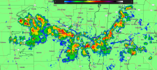
Yep. I didn’t think June would turn out so active and not all tornadoes confirmed yet but 40 plus tornadoes from June 15-22Almost at 1,000 confirmed tornadoes for the year!
URGENT - WEATHER MESSAGE
National Weather Service Peachtree City GA
1258 PM EDT Mon Jun 23 2025
GAZ001>005-007-011>014-019>025-027-030>039-041>062-066>076-078>086-
089>098-102>113-240100-
/O.NEW.KFFC.HT.Y.0001.250624T1700Z-250626T0000Z/
Dade-Walker-Catoosa-Whitfield-Murray-Gilmer-Chattooga-Gordon-
Pickens-Dawson-Floyd-Bartow-Cherokee-Forsyth-Hall-Banks-Jackson-
Madison-Polk-Paulding-Cobb-North Fulton-Gwinnett-Barrow-Clarke-
Oconee-Oglethorpe-Wilkes-Haralson-Carroll-Douglas-South Fulton-
DeKalb-Rockdale-Walton-Newton-Morgan-Greene-Taliaferro-Heard-
Coweta-Fayette-Clayton-Spalding-Henry-Butts-Jasper-Putnam-Hancock-
Warren-Troup-Meriwether-Pike-Upson-Lamar-Monroe-Jones-Baldwin-
Washington-Glascock-Jefferson-Harris-Talbot-Taylor-Crawford-Bibb-
Twiggs-Wilkinson-Johnson-Emanuel-Muscogee-Chattahoochee-Marion-
Schley-Macon-Peach-Houston-Bleckley-Laurens-Treutlen-Stewart-
Webster-Sumter-Dooly-Crisp-Pulaski-Wilcox-Dodge-Telfair-Wheeler-
Montgomery-Toombs-
Including the cities of Conyers, Roberts, Fort Valley, Riverdale,
Ellijay, Eastman, Butler, Monticello, Toomsboro, Woodstock,
Abbeville, Thomaston, Carrollton, Buena Vista, Monroe,
Lawrenceville, Columbus, Fort Benning, Vidalia, Cordele, Trenton,
Ellaville, Chatsworth, Stockbridge, Sparta, Sandersville,
Jackson, Cartersville, Forsyth, Athens, Swainsboro, Marietta,
Vienna, Montezuma, Lumpkin, Hawkinsville, West Point, Comer,
Barnesville, Homer, Manchester, Dawsonville, Winder,
Wrightsville, Summerville, Talbotton, Gainesville, Madison, Rome,
Cochran, Preston, Soperton, Zebulon, Americus, Fort Oglethorpe,
Watkinsville, LaFayette, Dallas, Jeffersonville, Peachtree City,
Pine Mountain, Gray, Dalton, Franklin, Crawford, Mcrae,
Louisville, Eatonton, Newnan, Greensboro, Covington, Bremen, East
Point, Warner Robins, Jasper, Douglasville, Macon, Warrenton,
GIbson, Cumming, Mount Vernon, Crawfordville, Alamo, Atlanta,
Decatur, Washington, Dublin, Cedartown, Commerce, Griffin,
Calhoun, and Milledgeville
1258 PM EDT Mon Jun 23 2025
...HEAT ADVISORY IN EFFECT FROM 1 PM TUESDAY TO 8 PM EDT WEDNESDAY...
* WHAT...Heat index values up to 107 expected.
* WHERE...Portions of central, east central, north central,
northeast, northwest, southeast, and west central Georgia.
* WHEN...From 1 PM Tuesday to 8 PM EDT Wednesday.
* IMPACTS...Hot temperatures and high humidity may cause heat
illnesses.
* ADDITIONAL DETAILS...Overnight temperatures Tuesday night will
provide limited relief, and heat index values will quickly rise
again Wednesday.
PRECAUTIONARY/PREPAREDNESS ACTIONS...
Drink plenty of fluids, stay in an air-conditioned room, stay out of
the sun, and check up on relatives and neighbors. Make adjustments
to outdoor activities, such as camps and sports. Provide shelter and
plenty of water for pets.
&&
$$

Finally it looks like we are now in shelf cloud photo season
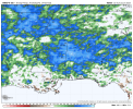
With the exception of (sometimes) getting big MCS's down, it's a crapshoot with the CAMs during the summer down here. Makes total sense, pop-up storms are not the same as big, synoptic setups. But yeah, if you wait for an afternoon with big storms and then pull up recent runs of the HRRR, you'll see it initiate reflectivity and then kill them all off immediately, which is rarely how it actually pans out.A word of caution when looking at the HRRR or any future radar during the Summer months. The HRRR and future radar models are pretty much useless with the exception being a thunderstorm complex and/or tropical system. Here's a perfect example. Current Radar vs. 00z HRRR from yesterday not showing any thunderstorms until 7pm this evening.
nice i hope you enjoy your view of that shelf cloud structureMaybe I'll see it from my porch! Been a notable lack of storms at home thus far this spring/now summer.
I would be very hesitant to expect a 100 degree or above high temperature given the last 30 day rainfall percentage of average especially in areas that have seen a lot of rainfall. I know my ground is still fairly saturated.Thanks, I hate it. Please pay close attention to your pets and kiddos this week!
View attachment 44439