
Navigation
Install the app
How to install the app on iOS
Follow along with the video below to see how to install our site as a web app on your home screen.
Note: This feature may not be available in some browsers.
More options
-
Welcome to TalkWeather! We see you lurking around TalkWeather! Take the extra step and join us today to view attachments, see less ads and maybe even join the discussion. CLICK TO JOIN TALKWEATHER
You are using an out of date browser. It may not display this or other websites correctly.
You should upgrade or use an alternative browser.
You should upgrade or use an alternative browser.
Severe Weather 2025
- Thread starter KevinH
- Start date

Kds86z
Member

TornadoFan
Member

Schoeppeya
Member
Texas storm about to produce
TornadoFan
Member

Kds86z
Member
Kds86z
Member
Kds86z
Member
AJS
Member
Jeez, that does look potentially strong.
kcyalater
Member

bro what….?!?
Ah yes *checks notes* small dinner plate sized hail. Everything really is bigger in Texas.View attachment 43238
bro what….?!?
To sustain the DVD size hail, your updraft winds in the storm would have to be around 171.2mph

Kds86z
Member
CheeselandSkies
Member
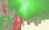
Storm northwest of Haskell, TX (or the one to it south over Aspermont, depending on what the impending merger does) looks like the best short-term tornado threat. Everything else in the area looks pretty messy IMO.
Given some of these hail reports, I'm not sorry I'm not out there tangling with that. Took a few quarters/half dollars to the face at my first setup location for Arnett, I don't want to be anywhere near 4-5"+.
Given some of these hail reports, I'm not sorry I'm not out there tangling with that. Took a few quarters/half dollars to the face at my first setup location for Arnett, I don't want to be anywhere near 4-5"+.
Healthy inflow on this storm in Gordon County, actually looks pretty good on reflectivity, but just nothing that sticks out. That said, mesos are coming and going on this line constantly, so possible that something spins up. FFC issued and then rapidly cancelled a TOR to the NE of this one.
