• Welcome to TalkWeather!
    We see you lurking around TalkWeather! Take the extra step and join us today to view attachments, see less ads and maybe even join the discussion.
    CLICK TO JOIN TALKWEATHER

Severe Weather 2025

View attachment 40148
View attachment 40149

12z Euro for next Tuesday. I'm no MET, and I don't really understand trough geometry and how it plays into how substantial a threat is all that good, but this looks particularly troublesome to me. Very tight dry line with a trough ushering in from the west.
To add to this, here's your sign of more trouble as well. Yes, that is definitely trouble.
 

Attachments

  • hazards_d3_7_contours.png
    hazards_d3_7_contours.png
    527.9 KB · Views: 0
  • precip_probhazards_d8_14_contours (5).png
    precip_probhazards_d8_14_contours (5).png
    891 KB · Views: 0
View attachment 40148
View attachment 40149

12z Euro for next Tuesday. I'm no MET, and I don't really understand trough geometry and how it plays into how substantial a threat is all that good, but this looks particularly troublesome to me. Very tight dry line with a trough ushering in from the west.
That’s pretty alarming this far out. This definitely needs to continue to be monitored.
 
View attachment 40148
View attachment 40149

12z Euro for next Tuesday. I'm no MET, and I don't really understand trough geometry and how it plays into how substantial a threat is all that good, but this looks particularly troublesome to me. Very tight dry line with a trough ushering in from the west.
Yeah, strong and growing signal for this time period for a very large area, from the Plains over into the Midwest and Midsouth. A parade of Atlantic-bound Highs have been keeping the threat for the Eastern Seaboard low, but this system looks like it may make some room for itself and bring at least a low-end threat for severe weather to parts of the Southeast at the end of the month.
NEXLABdpdt-00Z-20250429_gefsUS_con_probscp-20-100.gif
 
The way I figure, the Mid-South will be in a Slight Risk for both Sunday/Monday. Because April 28th is my birthday and No, I did not send out any birthday invitations to the severe storms/tornadoes.
 
Booked PTO for next week Monday-Wednesday. Sunday-Monday at the very least look potentially significant, possibly Tuesday as well. Although we've had a few teasers and Saturday's overachiever, this looks like the first synoptically evident, multi-day Plains threat of the year after nearly everything of note has been in the mid-MS Valley.

Nice that it worked out for me, since I have to be back for work Thursday-Saturday (5/1-3) and again the following week Monday-Tuesday due to other people already having those days off. Had me biting my nails a bit.
 
1000079430.gif
Days 6-8/Sun-Tue -- Great Plains to the Upper Midwest...

A more active severe weather period is possible early next week as
the western U.S. trough develops eastward into the Plains and Great
Lakes vicinity. The upper trough may begin ejecting into the
southern/central Plains as early as Day 6/Sun. However, the timing
of this feature may be ill-timed with peak diurnal
heating/destabilization such that stronger large-scale ascent and
increasing southwesterly flow aloft arrive overnight. Forecast
soundings Sunday afternoon suggest capping may limit convection.

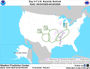
By Day 7/Mon, a strong midlevel jet streak should overspread
portions of the central/southern Plains into the Upper Midwest. Lee
cyclogenesis is forecast across the central High Plains, resulting
in a sharpening dryline across portions of the Great Plains, and
warm front extending across the eastern Dakotas to the Mid-MS
Valley. Rich Gulf moisture will be in place across the warm sector
and widely scattered severe storms appear possible from Monday
afternoon into Monday night. As is typical at longer time frames,
forecast guidance differs in exact timing and placement of key
features. However, the overall pattern is favorable for an
all-hazards severe weather episode, and a 15 percent delineation has
been included, though this area may shift over the coming days as
details become better resolved.

Severe potential may continue into Day 8/Tue across portions of the
Midwest to the southern Plains as a shortwave upper trough continues
across the Great Lakes into southeast Canada, and a cold front
impinges southeastward over portions of the region. Uncertainty
increases considerably during this time, precluding 15 percent
probabilities at this time.
 
View attachment 40159
Pretty large 15% severe probabilities issued for the 28th of April.
Haven't looked into the ingredients, but this just feels like one of those setups that will have a Day 4 - 8 30% issued before it reaches Day 1 - 3. Just saying that judging by the fact that they mentioned "scattered severe storms" and "all-hazards possible."
 
Haven't looked into the ingredients, but this just feels like one of those setups that will have a Day 4 - 8 30% issued before it reaches Day 1 - 3. Just saying that judging by the fact that they mentioned "scattered severe storms" and "all-hazards possible."
Yeah, whenever they mention all hazards possible quite far out, it’s definitely something to pay attention too.
 
Back
Top