tornado examiner
Member
We call em’ drillbit’s
Follow along with the video below to see how to install our site as a web app on your home screen.
Note: This feature may not be available in some browsers.
")
I was wondering if these were the same storms/closely tied to them, as well. I got woken up by the hail hitting our roof around 6:45 this morning! It was only quarter inch hail where I am, but I've seen some pictures of bigger stuff!Elevated supercells (one of them may have been the same storm as; or directly descended from last night's tornado-producers, I haven't had a chance to go back and look at the radar loops) produced a rather significant (by our standards) severe hail event across southern Wisconsin this morning. The HRRR portrayed this pretty well on a lot of the runs yesterday, however SPC didn't seem to impressed with only a marginal risk in place through 12Z (7 AM).
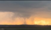
Not so innocent .. curious to see what it’s rated. I don’t think the Essex wedge touched a single home which is good.
Very excited to see the Essex tornado rated EF1 since it didn't touch a single house (sarcasm).
Not so innocent .. curious to see what it’s rated. I don’t think the Essex wedge touched a single home which is good.
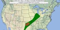
Not gonna lie, I haven't seen a more underwhelming setup for a slight risk in awhile. If I was able to storm chase anywhere today, it would 1000% be in central Oklahoma, where the most elevated tornado risk is at. Maybe Illinois might do a silly thing or two, but I doubt it.