US_Highway15
Member
Yeah not gonna lie I was kind of expecting more out of Portland, not just rain.Well today kind of disappointed me. I am lonesome for naders.Until next time…
Follow along with the video below to see how to install our site as a web app on your home screen.
Note: This feature may not be available in some browsers.
Yeah not gonna lie I was kind of expecting more out of Portland, not just rain.Well today kind of disappointed me. I am lonesome for naders.
Same… not even a dang severe warningYeah not gonna lie I was kind of expecting more out of Portland, not just rain.
Very low TOR probs on the SVR WW they issuedWell today kind of disappointed me. I am lonesome for naders.


I wasn't going to say anything until we got through the weekend, but yeah April 4th looks very interesting. Areas of interest is around southern Iowa, western llinois/northern Missouri area, as well as a secondary setup around east central Oklahoma, western Missouri and southeastern Kansas. Both areas of interest look very favorable for an outbreak of some kind.I know this is voodoo land. But April 4-8th on the EURO is filthy. This upcoming pattern looks dangerous.


Sooooo.. do you have any GIFs or??? lolI know this is voodoo land. But April 4-8th on the EURO is filthy. This upcoming pattern looks dangerous.
I got you for April 4th.Sooooo.. do you have any GIFs or??? lol
That timeframe will end up with a thread.


Funny enough, the same areas impacted this Sunday maybe impacted again 2-3 days later by a potentially impactful severe event and then again in 2-3 days. Active is the word I'll use lol.View attachment 37381
Holy mother of longwave trough from the 12z Euro for 4/2-4/3 timeframe.
The majority of the GFS ensemble members are lit up like a Christmas tree for April 2nd. This could get real ugly.
Wow smhI got you for April 4th.
Upper 60's dewpoint look to spread over IA/IL/MO, as well as OK/KS/MO, with winds between 70-80 knots about 500 mb (18,000 ft) around the IA/IL/MO area. Impressive winds around 850 mb in both areas of interest as well.
View attachment 37370
View attachment 37373
View attachment 37379
Mix that with CAPE values around 3000-3500 jkg around IA/IL/MO and SCP values between 5-8, and you got a potent setup.
View attachment 37374
View attachment 37375
Figured I would include the 0-3km EHI as well. Looks to be a bit more impressive around OK/KS/MO:
View attachment 37377
You don't see a tornado warning right on the Rio Grande everyday.
"Hey now, those roof shingles are contraband, you gotta leave those here."I wonder if they make the tornado go through customs. hopefully it remembered to bring its passport.
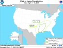
I made a quick mention about that in my Patreon post last night. CPC already has a Moderate Risk for Heavy Precipitation for that timeframe.The majority of the GFS ensemble members are lit up like a Christmas tree for April 2nd. This could get real ugly.