wx_guy
Member
- Messages
- 1,237
- Reaction score
- 4,443
- Location
- United States
- HAM Callsign
- KO4ZGH
- Special Affiliations
- SKYWARN® Volunteer
- ARRL Member
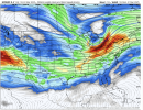
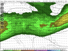
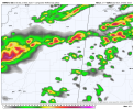
Finally got the output from the 18z run on my WRF-ARW model, and it's somewhat anticlimactic! If this model is anywhere close to accurate, the rain on Sunday will be light and non-severe. The ultra-resolution version I misconfigured, so I'll re-run it again in the morning and see if anything looks more impressive. But this is the high resolution version (5 km). The ultra resolution is 1 km (for comparison, the HRRR is 3 km). I think I've also got STP and SCP working too, so may see if they light up on the map tomorrow. (By the way, I need to change the label -- it uses the GFS initial conditions, but this is the WRF-ARW model, not GFS.)