
We got some severe threat over portions of the southeast today
Navigation
Install the app
How to install the app on iOS
Follow along with the video below to see how to install our site as a web app on your home screen.
Note: This feature may not be available in some browsers.
More options
-
Welcome to TalkWeather! We see you lurking around TalkWeather! Take the extra step and join us today to view attachments, see less ads and maybe even join the discussion. CLICK TO JOIN TALKWEATHER
You are using an out of date browser. It may not display this or other websites correctly.
You should upgrade or use an alternative browser.
You should upgrade or use an alternative browser.
Severe Weather 2025
- Thread starter KevinH
- Start date
tornado examiner
Member
It doesn’t look like its gonna completely fall apart like last time. Or at least, not as easily.
May verify as a significant outbreak in due time.
May verify as a significant outbreak in due time.
Looks like your gunna have supercells along the warm front this afternoon around the Gulf coast, very low tornado threat but they look cool lol. 
tornado examiner
Member
Wow 100,000 postsLooks like your gunna have supercells along the warm front this afternoon around the Gulf coast, very low tornado threat but they look cool lol. View attachment 34735
No it's the 100,000th post lol. I post a lot but I'm no where near 100,000 postsWow 100,000 posts
")
tornado examiner
Member
(confusion)No it's the 100,000th post lol. I post a lot but I'm no where near 100,000 posts
I have the title for the 100,000th post because I posted the 100,000th post on talk weather. Not because I've posted 100,000 times lol(confusion)
tornado examiner
Member
Ooooohhhhhhhh….lucky manI have the title for the 100,000th post because I posted the 100,000th post on talk weather. Not because I've posted 100,000 times lol
Wait.. WHAT?!
.gif")
- Thread starter
- #770
KevinH
Member
Wait WHAT?!!!? lolNo it's the 100,000th post lol. I post a lot but I'm no where near 100,000 posts
- Thread starter
- #771
KevinH
Member
Same lol(confusion)
- Thread starter
- #772
KevinH
Member
Oh…. HahahahahaI have the title for the 100,000th post because I posted the 100,000th post on talk weather. Not because I've posted 100,000 times lol
I noticed that tooAnother concern on the 0z GFS is that it pops a 997mb secondary low over NE MS at 21z on 3/15 as the nose of the main trough starts pushing through. That would definitely locally enhance the conditions there
12z GFS is back on that grind lol (this time with Alabama in on some fun)
tennessee storm chaser
Member
- Messages
- 1,876
- Reaction score
- 4,283
- Location
- jackson tennessee
- Special Affiliations
- SKYWARN® Volunteer
That would not be good…. Talking bout backing the winds big time. Wind profilesI noticed that too
tennessee storm chaser
Member
- Messages
- 1,876
- Reaction score
- 4,283
- Location
- jackson tennessee
- Special Affiliations
- SKYWARN® Volunteer
12z GFS is back on that grind lol (this time with Alabama in on some fun)
May not be fun you want12z GFS is back on that grind lol (this time with Alabama in on some fun)
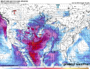
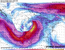
12z GFS Takeaways:
1. Surface Based Cape is not as impressive as yesterday's 18z run, but that's to be expected.
2. How low can you go? 12z GFS now has a 968mbar low over Kansas by Friday.
3. 500mb level looks very potent by next Friday.
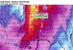
4. 12z depicting 120kt bulk shear value over Northeast MS by Sunday. By far the highest bulk shear I've seen in these parts in a while.
Summary:
Tight pressure gradient leading to Wind Advisories/High Wind Watches/Warnings over a widespread area. Just like with the most recent system. Multiple rounds of storms leading to flash flooding and severe weather/tornado outbreak. This potential threat will also include a large area from Texas, Oklahoma, Kansas, Arkansas, Louisiana, MS, Tennessee, Missouri, Alabama, Georgia, and Florida. If you don't get the storms, you'll definitely get the high wind.
1. Surface Based Cape is not as impressive as yesterday's 18z run, but that's to be expected.
2. How low can you go? 12z GFS now has a 968mbar low over Kansas by Friday.
3. 500mb level looks very potent by next Friday.
4. 12z depicting 120kt bulk shear value over Northeast MS by Sunday. By far the highest bulk shear I've seen in these parts in a while.
Summary:
Tight pressure gradient leading to Wind Advisories/High Wind Watches/Warnings over a widespread area. Just like with the most recent system. Multiple rounds of storms leading to flash flooding and severe weather/tornado outbreak. This potential threat will also include a large area from Texas, Oklahoma, Kansas, Arkansas, Louisiana, MS, Tennessee, Missouri, Alabama, Georgia, and Florida. If you don't get the storms, you'll definitely get the high wind.
Attachments
Last edited:
tennessee storm chaser
Member
- Messages
- 1,876
- Reaction score
- 4,283
- Location
- jackson tennessee
- Special Affiliations
- SKYWARN® Volunteer
12z is bad12z GFS Takeaways:
1. Surface Based Cape is not as impressive as yesterday's 18z run, but that's to be expected.
2. How low can you go? 12z GFS now has a 968mbar low over Kansas by Friday.
3. 500mb level looks very potent by next Friday.
4. 12z depicting 120kt bulk shear value over Northeast MS by Sunday. By far the highest bulk shear I've seen in these parts in a while.
Summary:
Tight pressure gradient leading to Wind Advisories/High Wind Watches/Warnings over a widespread area. Just like with the most recent system. Multiple rounds of storms leading to flash flooding and severe weather/tornado outbreak.
Hopefully I have a drone by the time this weather comes though. So I can add some ground truth to storms here in North Jefferson if needed this event, if it comes to fruition. Still early but I feel like we are getting closer to locking in on a general idea now.12z is bad
And also don't sleep on Wednesday. SPC is now hinting at a possible threat on Wednesday too.