Ledian
Member
Is that a couplet south of Gould?
Follow along with the video below to see how to install our site as a web app on your home screen.
Note: This feature may not be available in some browsers.
Yep a strong one tooIs that a couplet south of Gould?
As the short wave accelerates into and through the confluent regime,
models indicate that the cyclone will weaken while migrating across
the central Great Plains into Ohio Valley. But a trailing cold
front may provide a focus for renewed frontal wave development, as
an upstream mid-level perturbation accelerates east of the Texas Big
Bend through the south Atlantic Seaboard by late next weekend. This
may be accompanied by moistening and destabilization across parts of
the central and eastern Gulf into south Atlantic Coast states on
Saturday into Sunday, in the presence of strengthening shear. This
could contribute to an environment at least marginally supportive of
organized strong thunderstorm development. However, barring
stronger cyclogenesis than currently forecast across the Southeast,
the severe weather potential still appears relatively low.
..Kerr.. 03/03/2025


View attachment 34509
View attachment 34510
Haven’t seen a set of GFS ensemble members quite like this in a long time. Maybe this one will actually be a big deal.


DANG! Honestly not surprising in the least though.Strongest GEFS concurrence at this range I can remember in some time for this part of the world. The troughing is showing up on most ensembles in a really impressive fashion. CIPS still really zoning in on this period as well. Would really start keeping an eye on this period. After this, we may still have more active weather as the late month comes around.
View attachment 34519View attachment 34520View attachment 34521View attachment 34522View attachment 34523View attachment 34524
Yeah the pattern is there. Will have to see about moisture though.View attachment 34509
View attachment 34510
Haven’t seen a set of GFS ensemble members quite like this in a long time. Maybe this one will actually be a big deal.

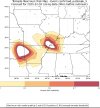
That’s awesome. Are you incorporating topographic data into your model? If you happen to have a githib repo for your project, I’d love to check it out. I geek out over coding + weather.I mentioned a few days ago that I'm training my very own custom tornado model that blends traditional weather modeling algorithms with quantum entanglement to more accurate predict the timing, location and intensity of tornadoes. The objective is to create a model that can predict individual tornado tracks, timing and intensity within a 5 mile margin of error and with a <15 minute margin hours before the event itself.
I'm happy to report the results so far have been quite promising, although more refinement is needed. Here's the projected risk map from an individual event I backtested (December 10th, 2023, the Mayfield Tornado)
The image below shows the model's prediction of the event roughly 12 hours before the main tornado forms (about the same time as an SPC 06Z update, or the first D1 forecast).
Obviously there's some noise/data leakage that needs to be addressed (the big 2nd risk are on the left is a clear false positive), but the model produced a highly accurate forecast for the tornadogensis coordinates of the Mayfield tornado.
I'll continue refining the model and will start running it on upcoming events!


Soooooo we (potentially) have the 8th, 12th, 14th… SMHCIPS and CSU's probs are picking up on the possibility of a threat March 8th or so, but not confident about moisture return and SPC is skeptical. Still, the big period to watch is mid-month. Large-scale stuff is clearly going to be in place, will just be a question of how it ultimately evolves.
View attachment 34587View attachment 34589
View attachment 34590View attachment 34591View attachment 34592View attachment 34593View attachment 34594View attachment 34595View attachment 34596View attachment 34597
The gfs 12z holding on to that strong system on 15th…. Anxious see how the euro handles this system when gets into good range …