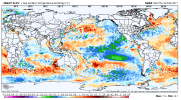
00z EPS last night and 12z GEFS today are frankly textbook come mid March for an uptick in severe weather potential.
Follow along with the video below to see how to install our site as a web app on your home screen.
Note: This feature may not be available in some browsers.
Seeing. Whole lot of 2011 also being used . Actually perhaps top analogI've seen 2006 come up a lot as an analog. It's considered a poor chase season due to a fairly quiet May-June, but the early season was rather active including a large outbreak from the eastern Plains to the mid-MS Valley on March 12th (it was a lot like 3/31/23 but shifted a few hundred miles to the west). Early April had several more events including another widespread one in the mid-MS Valley on 4/2 and then infamous 60% tornado outlook on April 7.
That year is coming up frequently in the recent replies of this thread from some credible peopleSeeing. Whole lot of 2011 also being used . Actually perhaps top analog

I was watching a video of Ryan Hall (yeah, I know) and he said something that kind of jolted my memory. He used the words “full latitude trough” for next week and for SOME reason that triggered the memory that those are bad was bad. I can’t remember why. For the Mets, what do you think about the full latitude trough that Ryan mentioned? (NOT Ryan himself, just the trough. This is not an invitation to bash Ryan.)
Thank youThe amount of latitude (distance N-S) a trough covers is related to how amplified it is. A "full latitude" trough will be quite amplified. However the wavelength (distance E-W between the trough axis and the axis of the preceding ridge) is also important. The worst of the worst tend to be highly amplified and have a broad wavelength (4/27 was one such case).
")
Hubba-hubba!00z EPS last night and 12z GEFS today are frankly textbook come mid March for an uptick in severe weather potential.
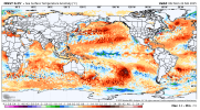
The difference between 2010-2011 and 2024-2025 is that 2010-2011 had a strong La Nina develop early that peaked in the fall and was in the beginning of its decaying stage come January and beyond that caused colder water to shift west as the eastern ENSO regions warmed, causing a +TNI. 2024-2025, we had a late developing La Nina that significantly intensified in Region 4 and 3.4 at the last minute to bring the overall SSTAs near the Equator to similar conditions by January through now as seen in early 2011. It's ended up being a situation of a different road leading to the same destination type thing. It's that destination we've arrived at with the highly positive TNI that will help drive the large scale pattern.Indeed. Does anyone have the SST values for the Gulf at this time and how that played into Spring 2011?
Gulf is apparently much warmer than it was in 2011. I will say there's some chatter about whether we're in a La Nina or not currently. NOAA thinks we are while if you go by the ONI index, we're not. Either way, if you read the current ENSO update (https://www.cpc.ncep.noaa.gov/products/analysis_monitoring/enso_advisory/ensodisc.shtml) vs. the February 2011 ENSO update (https://www.cpc.ncep.noaa.gov/products/CDB/CDB_Archive_html/bulletin_022011/Forecast/forecast.shtml), both were forecasted to trend towards Neutral by Spring or by June.
Ah okay. Gotcha. Thank you my friend as always for your input!The difference between 2010-2011 and 2024-2025 is that 2010-2011 had a strong La Nina develop early that peaked in the fall and was in the beginning of its decaying stage come January and beyond that caused colder water to shift west as the eastern ENSO regions warmed, causing a +TNI. 2024-2025, we had a late developing La Nina that significantly intensified in Region 4 and 3.4 at the last minute to bring the overall SSTAs near the Equator to similar conditions by January through now as seen in early 2011. It's ended up being a situation of a different road leading to the same destination type thing. It's that destination we've arrived at with the highly positive TNI that will help drive the large scale pattern.
Absolutely love your posts @Fred Gossage. Thanks for helping to keep everyone thinking clearly.Don't get too wrapped up in specific seasonal analogs being mentioned. Seasonal Analog X =/= headliner event from Season X necessarily repeating. HOWEVER, analogs being thrown around are being mentioned for a reason, and that reason is not just people pulling them out of their gastrointestinal tracts. There are valid substantial similarities on the global and teleconnection scale to seasons being mentioned. A similar background state as a prior season does make it significantly less impossible than usual to have a similar outcome. Just don't get hyper-focused on a specific year or a specific date mentioned as an analog. That does nobody any good. It's up to the individual synoptic waves themselves to take advantage of the background state to whatever extent they will and help drive mesoscale factors to produce whatever end result there is. That, we can't know yet. But you don't get uncommonly favorable background states and absolutely nothing happen. The strong message is that the coming two months may be active. No, it's not going to wait until April. And now is the time to prepare.... without panicking over analogs being mentioned (valid as they are).
I don't have specific memory of the exact synoptics of everything at the time, but I do remember there was a lot of building heat in the Gulf leading up to the Easter 2020 outbreak. Helped facilitate moisture return and maintaining instability across the South well into the evening, alongside the very strong LLJ.Indeed. Does anyone have the SST values for the Gulf at this time and how that played into Spring 2011?
Gulf is apparently much warmer than it was in 2011. I will say there's some chatter about whether we're in a La Nina or not currently. NOAA thinks we are while if you go by the ONI index, we're not. Either way, if you read the current ENSO update (https://www.cpc.ncep.noaa.gov/products/analysis_monitoring/enso_advisory/ensodisc.shtml) vs. the February 2011 ENSO update (https://www.cpc.ncep.noaa.gov/products/CDB/CDB_Archive_html/bulletin_022011/Forecast/forecast.shtml), both were forecasted to trend towards Neutral by Spring or by June.
When you see the MJO repeatedly amplify in the Indian Ocean and amplification is blocked over the Pacific, that will continue. That means the next time it cycles and amplifies again, likely in the back half of April, it will likely amplify again in the Indian Ocean. That MJO phase is favorable for ridging being off the East Coast and us being in low-latitude SW flow aloft here... favorable for severe in the spring and favorable for southern wintry weather early in the year. In order for stuff to shift north/west of Dixie, you want the MJO to amplify closer to the Pacific so that ridging is stronger and closer to the Southeast coastline or onshore, or you just want the seasonal migration that happens after April. In late May 2011, the MJO cycled again and amplified in the IO, but the seasonal migration northwestward had already begun, and the pattern still aimed at the Plains instead.Absolutely love your posts @Fred Gossage. Thanks for helping to keep everyone thinking clearly.
This season may start off early, but it will be interesting to see WHERE things play out (if at all??) over the next two months.
Very general question, as I’m a complete amateur in the field of meteorology, but what is the MJO? I’ve heard it repeated multiple times here, but I’ve never asked. Is it directly related to Niño/Niña patterns?When you see the MJO repeatedly amplify in the Indian Ocean and amplification is blocked over the Pacific, that will continue. That means the next time it cycles and amplifies again, likely in the back half of April, it will likely amplify again in the Indian Ocean. That MJO phase is favorable for ridging being off the East Coast and us being in low-latitude SW flow aloft here... favorable for severe in the spring and favorable for southern wintry weather early in the year. In order for stuff to shift north/west of Dixie, you want the MJO to amplify closer to the Pacific so that ridging is stronger and closer to the Southeast coastline or onshore, or you just want the seasonal migration that happens after April. In late May 2011, the MJO cycled again and amplified in the IO, but the seasonal migration northwestward had already begun, and the pattern still aimed at the Plains instead.
Tropical area forcing of upward and downward motion waves that cycle around the globe and drive the main weather patterns, essentially.Very general question, as I’m a complete amateur in the field of meteorology, but what is the MJO? I’ve heard it repeated multiple times here, but I’ve never asked. Is it directly related to Niño/Niña patterns?