Parker Copeland
Member
oh, more svr weather? noted
Follow along with the video below to see how to install our site as a web app on your home screen.
Note: This feature may not be available in some browsers.
oh, more svr weather? noted
none, I meant in tracking termsWhat kind of severe weather are you getting?
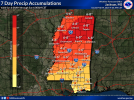
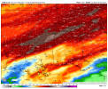
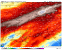
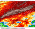
Flooding is going to be a real concern here in the Tennessee Valley next. If the GFS or Euro were to verify…yikes!
View attachment 33455
maaaan, If that does happen, I hope to mf god nobody is near Lake Lure, cuz that dam still has erosion on both sides and was still structurally comp from pre-Helene...... So if *ANY* form of heavy precip occurs, that sucker could jus go, and its not a small dam either.Yikes, looks like some of the highest totals are over the same areas that got wrecked by flooding in Helene.
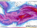
Last several runs of the GFS also looks like a definite severe potential across some parts of the South on the 15th, with the usual caveats that it's a week out and the exact scope/ceiling will depend on the trough evolution. Latest 0Z run looks somewhat positively tilted and sheared out - not so much to be a total deal-breaker, but enough that the majority of the forcing, and the core of the LLJ are somewhat displaced from the most unstable part of the warm sector.


a signal is a signal, they don't typically look good far out and can offen times just uptrend or die and disappear. def keep an eye out.2 notable risk periods showing up. Usual caveats apply. At a glance, 15th period looks more potent from a synoptic perspective. Like Cheese said, not optimal-looking setup at this point but it would pose a threat in the South. Worth watching.
View attachment 33467View attachment 33468View attachment 33469


...DISCUSSION...
...Sabine Valley into Lower Mississippi Valley Vicinity...
Precipitation appears likely to be ongoing within the warm advection
zone near the cold front on Wednesday. The primary shortwave
perturbation within the broader cyclonic flow aloft is expected to
move from the southern Plains into the mid-Mississippi Valley by the
afternoon. A weak surface wave will develop along the front and
quickly move northeast. This overall pattern will not favor
significant northward progression of Gulf moisture. With deep-layer
shear remaining parallel to the boundary, a broad warm advection
regime, and stronger ascent displaced northward, confidence in more
than isolated disorganized severe storms is low.
The intrusion of cold air into the Gulf on Friday is expected to be
greater than earlier in the week. Portions of the northern Gulf are
likely to be impacted with some potential the cold air to reach the
central Gulf. By Friday afternoon, the next upper-level trough is
forecast to reach the Southwest with a lee cyclone developing in
eastern Colorado. With the low deepening as it moves into the
Mid-South, rapid northward moisture return is possible within the
region through the day Saturday. This pattern would support severe
storms. Model guidance has had some consistency with the broad
pattern evolution, but has continued to differ run to run with
timing and intensity of key features. Further, given the colder air
that will be in place prior to any moisture return, the overall
quality of the airmass ahead of the upper trough is also not
certain. Trends in guidance will continue to be monitored for this
coming Saturday.
...Portions of the Southeast...
As the surface low moves northeast, it is expected to deepen as it
moves into the southern/central Appalachians on Thursday. This will
push the cold front into Georgia and the Carolinas. A narrow
warm-sector ahead of the front may destabilize enough for isolated
strong to severe storms, but confidence in more widespread activity
is low given the uncertain buoyancy and the increasingly
northward-displace mid-level ascent.
On Sunday, based on current guidance, a similar scenario to Thursday
will occur. However, the trough/surface low are forecast to be
stronger and there is greater potential for a larger warm sector.
Uncertainty remains high this far in advance, however.
..Wendt.. 02/09/2025