Cyclonic Paracosm
Member
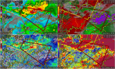
 ahh, supercell. s tier app
Follow along with the video below to see how to install our site as a web app on your home screen.
Note: This feature may not be available in some browsers.
ahh, supercell. s tier app
I know somebody on the French Broad there. Rotation went directly over their house and they didn't hear anything. Probably a solid funnel if it were daylight.There might be something on the north side of Sevierville
Oh no…..Apparently had a touchdown near Deerlodge, Tn. Several homes damages along with trees down with possible fatalities per a storm report from law enforcement.

Apparently had a touchdown near Deerlodge, Tn. Several homes damages along with trees down with possible fatalities per a storm report from law enforcement.

This is also the first February tornado for NWS Morristown since 2011.Preliminary survey results indicate an EF-2 with 135 max winds in Morgan County, TN near Deer Lodge.
This is first tornado on record in February for Morgan County.
With the possibility of up to 7 inches of rainfall here (yuck) i believe it. Been a while since Pontotoc looked to be under the gun for something quite nasty, but hopefully either strength/odds will weaken before then, or i'll be fortunate enough to have not much happen here.Signals have improved for two potential severe weather events middle of next week and next weekend across the Southeast.
That's much more intense than what I expected, wow. Looks like their intensity range estimate was (nearly) spot on.Preliminary survey results indicate an EF-2 with 135 max winds in Morgan County, TN near Deer Lodge.
This is first tornado on record in February for Morgan County.