
Navigation
Install the app
How to install the app on iOS
Follow along with the video below to see how to install our site as a web app on your home screen.
Note: This feature may not be available in some browsers.
More options
-
Welcome to TalkWeather! We see you lurking around TalkWeather! Take the extra step and join us today to view attachments, see less ads and maybe even join the discussion. CLICK TO JOIN TALKWEATHER
You are using an out of date browser. It may not display this or other websites correctly.
You should upgrade or use an alternative browser.
You should upgrade or use an alternative browser.
Severe Weather 2025
- Thread starter KevinH
- Start date
Kds86z
Member
Kds86z
Member

Kds86z
Member

Kds86z
Member
Not so sure that's a tornado. Very possible there was indeed one OTG at the time, but that may well be scud.
Kds86z
Member
GotchaNot so sure that's a tornado. Very possible there was indeed one OTG at the time, but that may well be scud.
Kds86z
Member
Kds86z
Member
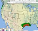
Happy day 1. Texas and Oregon/Washington
N ADDITION, 0-3 KM STORM RELATIVE-HELICITY IS FORECAST TO BE IN THE
200 TO 250 M2/S2 RANGE OVER THE MIDDLE TEXAS COASTAL PLAIN
SUGGESTING THAT A FEW TORNADOES WILL BE POSSIBLE. A POTENTIAL WILL
EXIST FOR A STRONG TORNADO, ALTHOUGH THIS REMAINS UNCERTAIN. THE
STORMS ARE EXPECTED TO CONGEAL INTO A LINEAR CONVECTIVE SYSTEM BY
EARLY EVENING. A POTENTIAL FOR DAMAGING WIND GUSTS WILL EXIST ALONG
THE LEADING EDGE OF THE LINE, WITH THE THREAT CONTINUING INTO THE
EARLY OVERNIGHT PERIOD, ALONG AND NEAR THE COAST OF SOUTHERN
LOUISIANA.
Attachments
Kds86z
Member
AJS
Member
Wouldn’t be surprised to see them upgrade to an enhanced risk for today.Happy day 1. Texas and Oregon/Washington
N ADDITION, 0-3 KM STORM RELATIVE-HELICITY IS FORECAST TO BE IN THE
200 TO 250 M2/S2 RANGE OVER THE MIDDLE TEXAS COASTAL PLAIN
SUGGESTING THAT A FEW TORNADOES WILL BE POSSIBLE. A POTENTIAL WILL
EXIST FOR A STRONG TORNADO, ALTHOUGH THIS REMAINS UNCERTAIN. THE
STORMS ARE EXPECTED TO CONGEAL INTO A LINEAR CONVECTIVE SYSTEM BY
EARLY EVENING. A POTENTIAL FOR DAMAGING WIND GUSTS WILL EXIST ALONG
THE LEADING EDGE OF THE LINE, WITH THE THREAT CONTINUING INTO THE
EARLY OVERNIGHT PERIOD, ALONG AND NEAR THE COAST OF SOUTHERN
LOUISIANA.
WeathermanLeprechaun
Member
Considering starting a thread for today but a bit uncertain.... Latest D1 acknowledges a strong tornado at play however.
Ft. Worth office last night...

AJS
Member
I’d go ahead.Considering starting a thread for today but a bit uncertain.... Latest D1 acknowledges a strong tornado at play however.
AJS
Member
Just wanted to say that was probably one of the most intense early morning lines of thunderstorms that’s ever came through my area. The tornado warning was around 3-3:45 AM and thankfully missed my area to the north, but man. A lot of our trees are bent and our furniture out on the back patio has been blown down. Gearing up for later now though as the next round has the potential to be even more intense.
- Moderator
- #7,358
Considering starting a thread for today but a bit uncertain.... Latest D1 acknowledges a strong tornado at play however.
Go ahead and I'll stick it to the top. (Just do it soon because I have to run errands in a bit.
") )
)Man the hrrr has some nice semi discreet supercells on land near the coast in Texas later today.
Also here's a link to the thread.
Thread 'Severe Weather Threat - October 25th, 2025' https://talkweather.com/threads/severe-weather-threat-october-25th-2025.2459/
Also here's a link to the thread.
Thread 'Severe Weather Threat - October 25th, 2025' https://talkweather.com/threads/severe-weather-threat-october-25th-2025.2459/
WeathermanLeprechaun
Member
I keep forgetting to share it here so more know smh, thanks!Man the hrrr has some nice semi discreet supercells on land near the coast in Texas later today.
Also here's a link to the thread.
Thread 'Severe Weather Threat - October 25th, 2025' https://talkweather.com/threads/severe-weather-threat-october-25th-2025.2459/