• Welcome to TalkWeather!
    We see you lurking around TalkWeather! Take the extra step and join us today to view attachments, see less ads and maybe even join the discussion.
    CLICK TO JOIN TALKWEATHER

Severe Weather 2025

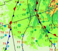
Potential for a large trough (especially for the time of year) to drop into the west come the end of this week into early next. A cutoff low in the Gulf could introduce complications regarding evolution of this system and moisture return, but given the amount of rain we've had recently and that it is now getting into June, the latter should be less of an issue.

We could be looking at a scenario with several days of southwest flow from the Plains into the Midwest, which tends to yield well come late season. CPC analogs are full of active periods for the time of year.
 
For May 25, it was Kerr who issued the original, more conservative Day 2 outlook. Which, despite some indications to the contrary at the time, ended up being closer to reality.
You are correct sir, it was the May 25th event. I don’t think I’ve ever read something on here and laughed as hard as I did as when I read your post here:

From the ST Discord, regarding Sunday's outlook: "Kerr needs to reassess his time at the SPC."
 
Here comes more severe storms. Round 258 or something, I've lost count at this point. An SVA has been issued for this new activity.
SOUTHMISSVLY_loop (2).gif
 
Here comes more severe storms. Round 258 or something, I've lost count at this point. An SVA has been issued for this new activity.
View attachment 43333
Man I got soaked in that gully washer that went through downtown bham earlier. I'm tired of these storms already and it's not even technically pop up season lol
 
Thankfully, with all this rain we're having, this should keep us from hitting 100+ for a good while.
 
Radar indicated tornado warning for Huntsville, AL - Madison Co. Wasn't expecting that, especially since there's not much on radar.
I live SW of Hampton Cove so that warning was just to the northeast of me. Couldn't see any obvious lowering in the clouds but broad rotation over my house was pretty clearly visible. Spin-ups as storms cross Monte Santo/Green Mountain are not uncommon.
 
The UAH radar had a better look at it and saw a TDS, which led to the warning. But I think it spun down just a quickly as it spun up.
This was quite the low-topped mini-supercell, with the mesocyclone barely visible on KHTX at any given point. Looks like echo tops barely breached 25,000 ft. at highest. Don't doubt it dropped one, though. Not much in the way of kinematics in this area though, but 50-75 m2/s2 in the lowest 500 meters probably managed to be enough for it to touch down briefly.
1748393723723.png
 
HUN just issued another one for roughly the same location over Redstone Arsenal.

The National Weather Service in Huntsville Alabama has issued a* Tornado Warning for... Southern Madison County in north central Alabama... East central Morgan County in north central Alabama...* Until 900 PM CDT.*

At 814 PM CDT, a severe thunderstorm capable of producing a tornado was located near Morgan City, or near Redstone Arsenal, moving northeast at 15 mph.

HAZARD...Tornado.

SOURCE...Radar indicated rotation.

IMPACT...Flying debris will be dangerous to those caught without shelter. Mobile homes will be damaged or destroyed. Damage to roofs, windows, and vehicles will occur. Tree damage is likely.

* This dangerous storm will be near... Redstone Arsenal and Huntsville around 820 PM CDT. Owens Cross Roads around 835 PM CDT.Other locations impacted by this tornadic thunderstorm include Ryland, Hampton Cove, Laceys Spring, Farley, Whitesburg, and Brownsboro.

PRECAUTIONARY/PREPAREDNESS ACTIONS...TAKE COVER NOW! Move to a basement or an interior room on the lowest floor of a sturdy building. Avoid windows. If you are outdoors, in a mobile home, or in a vehicle, move to the closest substantial shelter and protect yourself from flying debris.
 
As Spann says: "When it comes to thunderstorms, expect the unexpected."

Crazy stuff though.

Your CAPE and Dews are definitely tornado favored.

Anyone have a sounding for around Huntsville?
 

Attachments

  • Screenshot 2025-05-27 202452.png
    Screenshot 2025-05-27 202452.png
    151.3 KB · Views: 0
  • Screenshot 2025-05-27 202616.png
    Screenshot 2025-05-27 202616.png
    458 KB · Views: 0
Back
Top