
2-3 bowing segments on this line in Alabama. Probably some gnarly winds occuring.
Navigation
Install the app
How to install the app on iOS
Follow along with the video below to see how to install our site as a web app on your home screen.
Note: This feature may not be available in some browsers.
More options
-
Welcome to TalkWeather! We see you lurking around TalkWeather! Take the extra step and join us today to view attachments, see less ads and maybe even join the discussion. CLICK TO JOIN TALKWEATHER
You are using an out of date browser. It may not display this or other websites correctly.
You should upgrade or use an alternative browser.
You should upgrade or use an alternative browser.
Severe Weather 2025
- Thread starter KevinH
- Start date

Outflow boundary is moving southeast into Jefferson county, may get windy before the real wind gets here.
Nice little bow echo about to hit me
Kds86z
Member
DalamNice little bow echo about to hit me

Paging @stallions3peat
Post those drone shots here
Post those drone shots here
Dime to nickle size hail here in Crestwood
stallions3peat
Member
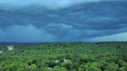
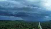
These are awesome manFinally got the drone up, every storm that's came through has been at night when I'm asleep it seems.
Kds86z
Member

AJS
Member
Absolutely torrential rainfall happening in Cypress rn.
atrainguy
Member
Supposedly off Thompson Bridge Rd near Gainesville, GA.
Okay, I was about to post about this SVR and ask why in the world there's a TOR possible tag on it, but I understand now
")
BULLETIN - IMMEDIATE BROADCAST REQUESTED
Severe Thunderstorm Warning
National Weather Service Peachtree City GA
754 PM EDT Fri May 2 2025
The National Weather Service in Peachtree City has issued a
* Severe Thunderstorm Warning for...
Southeastern Lumpkin County in north central Georgia...
Southeastern Dawson County in north central Georgia...
Northwestern Hall County in north central Georgia...
* Until 830 PM EDT.
* At 754 PM EDT, a severe thunderstorm was located near War Hill
Park, or 8 miles northwest of Gainesville, moving northeast at 35
mph.
HAZARD...Quarter size hail.
SOURCE...Radar indicated.
IMPACT...Damage to vehicles is expected.
* Locations impacted include...
Gainesville, Murrayville, and War Hill Park.
PRECAUTIONARY/PREPAREDNESS ACTIONS...
Remain alert for a possible tornado! Tornadoes can develop quickly
from severe thunderstorms. If you spot a tornado go at once into the
basement or small central room in a sturdy structure.
For your protection move to an interior room on the lowest floor of a
building.
If you see wind damage...hail or flooding...wait until the storm has
passed...and then call the National Weather Service toll free
at 1 8 6 6 7 6 3 4 4 6 6 or tweet us your report at NWSATLANTA.
&&
LAT...LON 3443 8378 3430 8392 3431 8395 3433 8395
3434 8398 3433 8402 3434 8404 3451 8395
3451 8385
TIME...MOT...LOC 2354Z 215DEG 29KT 3438 8394
TORNADO...POSSIBLE
HAIL THREAT...RADAR INDICATED
MAX HAIL SIZE...1.00 IN
WIND THREAT...RADAR INDICATED
MAX WIND GUST...<50 MPH
$$


Gail
Member
The storm that came over us in Lowndes County, MS definitely dropped some hail (I got caught in it) as well as strong winds and very heavy rain. I was waiting in line to pick up my kiddo from school and got pics of the greenish glow in the sky before it started.


Last edited:
Sharpy
Member
Didn’t get a picture, but I had some nice clouds moving in my part of central AL - had to race between getting steaks done on the grill and the line moving in. Still getting steady rain, but nonetheless wasn’t a bad storm passing through.
Ledian
Member

Just got finished going thru GoPro footage from 3 rounds of storms today. Whew
Kds86z
Member
Today was a let down for tornado boundary action but definitely an active day nonetheless.