AJS
Member
Chasers say reorganizing and pulling the outflow boundary back in
Which storm?
Follow along with the video below to see how to install our site as a web app on your home screen.
Note: This feature may not be available in some browsers.
Chasers say reorganizing and pulling the outflow boundary back in
Which storm?
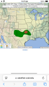
What was it showing?12z euro was rather robust for the mid south/south for roughly wensday night-thursday.


Severe Weather Statement
National Weather Service Norman OK
236 PM CDT Sat Apr 26 2025
OKC005-013-262000-
/O.CON.KOUN.TO.W.0056.000000T0000Z-250426T2000Z/
Bryan OK-Atoka OK-
236 PM CDT Sat Apr 26 2025
...A TORNADO WARNING REMAINS IN EFFECT UNTIL 300 PM CDT FOR NORTH
CENTRAL BRYAN AND SOUTH CENTRAL ATOKA COUNTIES...
At 236 PM CDT, a confirmed tornado was located 5 miles north of
Bokchito, moving northeast at 15 mph.
HAZARD...Damaging tornado and quarter size hail.
SOURCE...Weather spotters confirmed tornado.
IMPACT...Flying debris will be dangerous to those caught without
shelter. Mobile homes will be damaged or destroyed. Damage
to roofs, windows, and vehicles will occur. Tree damage is
likely.
Locations impacted include...
Caddo, Bokchito, Bennington, and Caney.
PRECAUTIONARY/PREPAREDNESS ACTIONS...
To repeat, a tornado is on the ground. TAKE COVER NOW! Move to a
storm shelter, safe room, or an interior room on the lowest floor of
a sturdy building. Avoid windows. If you are outdoors, in a mobile
home, or in a vehicle, move to the closest substantial shelter and
protect yourself from flying debris.
&&
LAT...LON 3418 9594 3416 9596 3416 9598 3415 9598
3415 9596 3399 9605 3406 9630 3425 9624
TIME...MOT...LOC 1936Z 206DEG 15KT 3410 9613
TORNADO...OBSERVED
MAX HAIL SIZE...1.00 IN
$$
MDU