
Navigation
Install the app
How to install the app on iOS
Follow along with the video below to see how to install our site as a web app on your home screen.
Note: This feature may not be available in some browsers.
More options
-
Welcome to TalkWeather! We see you lurking around TalkWeather! Take the extra step and join us today to view attachments, see less ads and maybe even join the discussion. CLICK TO JOIN TALKWEATHER
You are using an out of date browser. It may not display this or other websites correctly.
You should upgrade or use an alternative browser.
You should upgrade or use an alternative browser.
Severe Weather 2024
- Thread starter KevinH
- Start date
- Thread starter
- #883
KevinH
Member
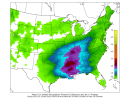
I smell a thread (not by ME though…. For now lol)18z GFS CWASP. At face value, it's hinting at a multi-day severe weather event.
Some of the more impressive values I've seen this year, though of course only time will tell how potent it'll actually be. But yeah, verbatim it looks pretty substantial.18z GFS CWASP. At face value, it's hinting at a multi-day severe weather event.
Right. Either way though heavy rain/flash flooding looks like the primary concern for the time being.Some of the more impressive values I've seen this year, though of course only time will tell how potent it'll actually be. But yeah, verbatim it looks pretty substantial.
ashtonlemleywx
Member
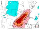
It seems that low will occlude and break off over the Southwestern states like the GFS and Euro are depicting on the 500mb.....it has consistently been depicted run to run.
I still have a lot of uncertainty of how it will interact with that subtropical jet and eject.
Somebody with meteorology knowledge help me understand.
I still have a lot of uncertainty of how it will interact with that subtropical jet and eject.
Somebody with meteorology knowledge help me understand.
Least it's on Friday and the weekend.
I may make a thread later today
I may make a thread later today
Justin Hindman Hindy
Member
Least it's on Friday and the weekend.
I may make a thread later today
These events have just sucked over the last month lol
pritchlaw
Member
Spann is saying right now wind profiles show no tornado threat for North and Central Alabama (ABC 33/40 coverage area) on Friday.

- Thread starter
- #891
KevinH
Member
Least it's on Friday and the weekend.
I may make a thread later today
Calm down… it’s too soon
Hey now , my severe wx prediction skills are impeccable I know when there needs to be a threadCalm down… it’s too soon
") haha
hahaCheeselandSkies
Member
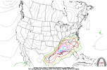
NAM came in rather hot for the Midwest on Thursday...
Sent from my Pixel 4a using Tapatalk
Sent from my Pixel 4a using Tapatalk
warneagle
Member
Good to know we’re not the only ones who have been getting dumped on. This was along the channel in DC on Sunday (that railing is not supposed to be in the water). Last thing we need is another big rain event.All this rain will also make damaging winds more dangerous by way of trees.
Attachments
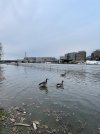
Well at least those geese seem to be enjoying the bountiful rains.Good to know we’re not the only ones who have been getting dumped on. This was along the channel in DC on Sunday (that railing is not supposed to be in the water). Last thing we need is another big rain event.
CheeselandSkies
Member
NAM came in rather hot for the Midwest on Thursday...
Sent from my Pixel 4a using Tapatalk
18Z held serve and even upped the ante a little bit with the surface thermos, although I think the 12Z looked slightly better at 500mb. Not really sold on this solution yet but certainly something to keep an eye on.
NWS Quad Cities not really sold, don't even mention the NAM solutions in their afternoon AFD. Just hail potential Wednesday night and mainly a rainfall event for Thursday.
Last edited:
Mrgolfman7070
Member
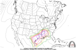
I read on Twitter about the Nam and gfs slowing the system and more amplified with recent runs. Dry air punching in as well with mid level jet and low level jet increasing. Would that increase the tornado threat?
CheeselandSkies
Member
Yes that would especially the NAM solutions I mentioned above. Still need to see a few more runs consistent with that idea before sounding the alarm.I read on Twitter about the Nam and gfs slowing the system and more amplified with recent runs. Dry air punching in as well with mid level jet and low level jet increasing. Would that increase the tornado threat?
Sent from my Pixel 4a using Tapatalk