SPC says wind damage threat increasing with the MCS over TN.
SUMMARY...Threat for damaging wind gusts increasing this afternoon
across WW 633. An additional Severe Thunderstorm Watch is possible
downstream and east of WW 633.
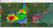
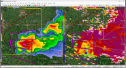
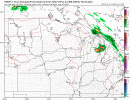
DISCUSSION...An organized QLCS is currently moving through WW 633
with a history of damaging wind reports. Cold pool deficits appear
to be around 10 degrees F based on observations at and around KBNA.
KOHX and TBNA radar observations also show multiple mesovortices
along the leading edge of the system's cold pool, particularly along
the eastern edge to the left of the system's apex.
Damaging wind gusts (40-55 kts) are expected to continue in WW 633
in association with this system. Current surface observations and
short-term RAP forecast profiles depict an uncapped boundary layer
and over 3000 J/kg of MLCAPE. Lower-layer lapse rates are not very
steep (around 6 C/km), but a residual elevated mixed layer aloft
(around and above 700 mb) will foster ample buoyant vertical
accelerations atop forced ascent along the outflow. RAP and NAM
profiles in the system's inflow depict modest veering shear in low
levels (around 15-20 kts from 0-1 km AGL) with west-northwesterly
flow around 40-50 kts aloft. When accounting for observed mesovortex
motion, much of the low-level shear is crosswise, at least prior to
potential mesoscale modification just ahead of the QLCS.
Interactions between the cold pool and local environment --
especially in the vicinity of a rear-inflow jet currently centered
near DeKalb County -- will continue to favor damaging-wind
production across WW 633. Multiple mesovortices will provide local
enhancements to the broader damaging-wind field, particularly along
and to the north of the bow apex in Middle TN. Convective trends
will continue to be monitored for possible downstream watch issuance
later this afternoon.
Storm Prediction Center Mesoscale Discussion 1966
Severe weather, tornado, thunderstorm, fire weather, storm report, tornado watch, severe thunderstorm watch, mesoscale discussion, convective outlook products from the Storm Prediction Center.
www.spc.noaa.gov