Austin Dawg
Member
I know it's waaaaaay out there but the end of the month shows a rather large system spinning up over the Southern plains and start moving east.
Follow along with the video below to see how to install our site as a web app on your home screen.
Note: This feature may not be available in some browsers.
Should we start giving credence to the GFS solution of a wintery precip threat???? 18z in that favorable position but 12z euro is a no go
Wut! Impressive!
Just imagine if you had a moderate to high instability setup with that. Big OOF
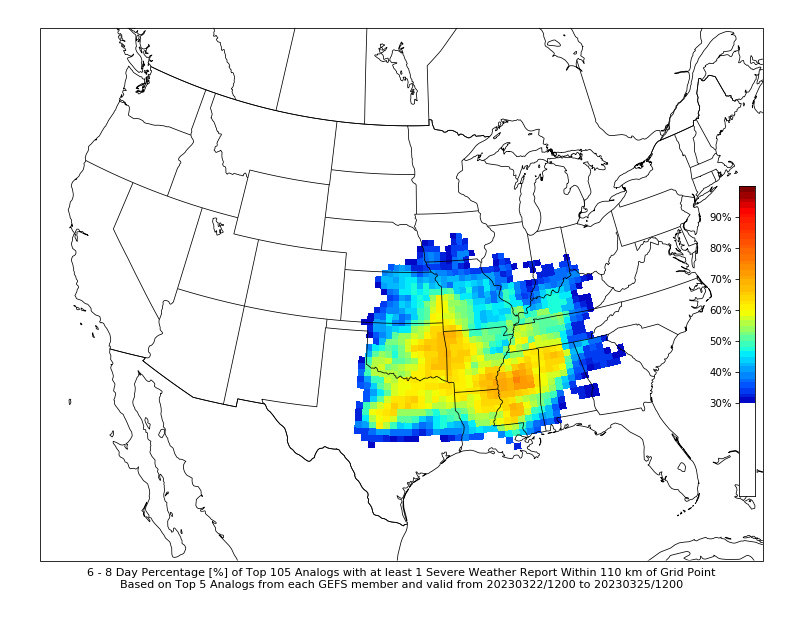
March 23rd-26th will most likely produce some level of severe weather. Impossible to tell how potent right now.
For what areas?The extended period looks active with two trough ejections. Thursday the 23rd/Friday the 24th as the first of interest and then Sunday the 27th. Both could serve potent as models have hinted.
April going be above average , what I am seeing teleconnections are lining up unfortunatelyIt's weird just how quickly it went quiet for this time of year. I mean we did have some severe weather with this last system but compared to what we have really been experiencing, it's been relatively quiet. I still think it's ramping back up toward the end of the month in April. It's going to be very interesting.
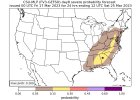
SPC has put in an area for next Thursday, but it's for the Southern Plains.

Here is an interesting perspective attm. All of the West, especially the mountains of coarse for the most part have tremendous snowpak. This should serve as to aid in the cold air/frontal positions to adequately hold the colder air at the 500mb levels and upward to remain longer intact with their eastward movement, and making the setups more volatile coming into Aprils warming trends.The extended period looks active with two trough ejections. Thursday the 23rd/Friday the 24th as the first of interest and then Sunday the 27th. Both could serve potent as models have hinted.