• Welcome to TalkWeather!
    We see you lurking around TalkWeather! Take the extra step and join us today to view attachments, see less ads and maybe even join the discussion.
    CLICK TO JOIN TALKWEATHER

Severe Weather 2022

The severe weather season for year 2022 will be?

  • Above Average

    Votes: 15 68.2%
  • Average

    Votes: 7 31.8%
  • Below Average

    Votes: 0 0.0%

  • Total voters
    22
  • Poll closed .
Status
Not open for further replies.

TH2002

Member
Sustaining Member
Messages
3,116
Reaction score
4,677
Location
California, United States
Special Affiliations
  1. SKYWARN® Volunteer
Encountered some monsoonal storms during a trip out to Yucca Valley today; unfortunately left the area before the bulk of the storms really arrived, regardless I can't help but do a bit of "landspout hunting" when I get the chance. Have yet to see one, but you never know I guess!
20220808_134407.jpg
20220808_141440.jpg
 

atrainguy

Member
Messages
718
Reaction score
1,021
Location
Linden, MI
Looks like Illinois is getting some tornadic action this afternoon. There is currently an observed tornado on the ground in the west part of the state. In the comments a person says it's reported as becoming rain wrapped. Meanwhile here in Michigan, we've been getting lots of traditional thunderstorms this afternoon, with some nice lightning action.


Taylor Campbell

Moderator
Moderator
PerryW Project Supporter
Messages
2,102
Reaction score
2,189
Location
Wedowee, AL
Special Affiliations
  1. SKYWARN® Volunteer
Anyone on this forum in the flooded area in MS.

That is some crazy rainfall totals out that way with several more inches expected.
 

Attachments

  • 673866B8-832D-43EE-A142-4E1F3847A76D.png
    673866B8-832D-43EE-A142-4E1F3847A76D.png
    1.9 MB · Views: 0
  • B84D3A44-D296-439E-A191-B1478A853765.png
    B84D3A44-D296-439E-A191-B1478A853765.png
    2 MB · Views: 0

Tennie

Member
Messages
935
Reaction score
761
Location
Tennessee
First 10% # probs in a while

View attachment 15096

The accompanying discussion also mentions a chance that it'll start out with discrete supercells before transitioning over to an MCS:

...IA/MO/IL/IN...
Scattered thunderstorms are expected to form near the front and
retreating outflow boundary late this afternoon into this evening
over IA. Initial mode should include supercells, one or two of
which may be persistent and cyclic enough for a threat of tornadoes
(some possibly strong) and/or significant, damaging hail.


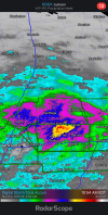
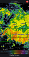
An ongoing area of clouds/precip, and embedded precip/thunderstorms
was evident in radar composites from central IL to portions of
central/eastern MO. This activity is expected to continue weakening
through the remainder of this morning, while its trailing outflow
boundary begins to retreat/reposition northward across northern MO
in the face of low-level WAA and diurnal heating. Some uncertainty
remains as to how far north the favorable airmass near the boundary
will retreat and surface cold front. However, given the latest
convective trends compared to assorted CAM guidance since 00Z, and
likelihood of diurnal heating to its north, the general idea remains
on track for strong surface-based destabilization to occur this
afternoon well into southern and perhaps part of central/eastern IA.
That destabilization should continue into the evening ahead of
convection that develops over IA as well, supporting its maintenance
and potential for upscale growth this evening.

The environment south of the front and near the retreating boundary
(which will broaden and become more shallow/diffuse with time) is
reasonably progged to be favorable for both early-stage supercells,
followed by upscale clustering/MCS development tonight.
Forecast
soundings suggest steep low/middle-level lapse rates atop upper 60s
to low 70s surface dewpoints, yielding MLCAPE commonly in the 2000-
3500 J/kg range south of the front. Mass response and large-scale
ascent ahead of the approaching shortwave trough will strengthen
vertical shear in tandem with the front and boundary, such that
effective-shear magnitudes of 45-60 kt may be realized, along with
effective SRH in the 200-400 J/kg range.

A small, unconditional significant-tornado area is being added
within the "enhanced" risk, and may need to be adjusted some as
mesoscale trends warrant. The already supercell-favorable ambient
environment will be augmented in the vorticity-maximized
remnant-boundary corridor, where the largest hodographs and very
rich boundary-layer moisture should be maintained. Any relatively
discrete storm remaining in this environment during maturity -- and
especially into the time window when the LLJ enlarges hodographs
still more -- could become an intense and cyclic (but perhaps also
heavy-precip) supercell.
A damaging-wind and sporadic large-hail
threat may persist through much of the night over parts of
central/northern IL into IN, both with the MCS and any convection to
its northeast in the strongest WAA/moisture-transport regime.
 
Messages
2,753
Reaction score
4,291
Location
Madison, WI
I'd be chasing this if the CAMs showed initiation a couple hours earlier/not right at dark this time of year.

Oh, and if the Packers didn't have the SNF game. Where is this setup in May?

Sent from my Pixel 4a using Tapatalk
 
Last edited:
Messages
1,031
Reaction score
1,220
Location
jackson tennessee
Special Affiliations
  1. SKYWARN® Volunteer
about time to wake up this thread , we are getting close to fall severe weather season... our secondary severe weather season... already seeing signs of fantasy troughs starting to show up. plus the main jet starting to head back south as fall season progresses. be intersting see what a third la nina holds for us
 
Status
Not open for further replies.
Back
Top