• Welcome to TalkWeather!
    We see you lurking around TalkWeather! Take the extra step and join us today to view attachments, see less ads and maybe even join the discussion.
    CLICK TO JOIN TALKWEATHER

Severe Weather 2021

Messages
1,056
Reaction score
1,278
Location
jackson tennessee
Special Affiliations
  1. SKYWARN® Volunteer
Spc has highlighted large area day 4 plains southern plains … models agree there could be day 5 threat further east toward Tennessee valley midsouth … could be buisy next week… euro still looks fairly ominous to me
 

Tennie

Member
Messages
960
Reaction score
791
Location
Tennessee
Spc has highlighted large area day 4 plains southern plains … models agree there could be day 5 threat further east toward Tennessee valley midsouth … could be buisy next week… euro still looks fairly ominous to me

For reference, here's the D4 outlook:

day4prob.gif

ZCZC SPCSWOD48 ALL
ACUS48 KWNS 210818
SPC AC 210818

Day 4-8 Convective Outlook
NWS Storm Prediction Center Norman OK
0318 AM CDT Thu Oct 21 2021

Valid 241200Z - 291200Z

...DISCUSSION...
(Day 4) Models are trending toward better agreement and have
demonstrated some run-to-run consistency regarding the evolution of
a southern-stream shortwave trough forecast to amplify as it
approaches the southern and central High Plains Saturday night. This
feature will move through the central/southern Plains Sunday before
reaching the middle/lower MS Valley Sunday evening. There are still
some model differences, particularly with regard to the amplitude
and speed of this system.

Deepening lee low should be situated over central KS by 12Z Sunday
with a trailing cold front extending southwestward into western TX.
A warm front will stretch eastward from the low through northern KS
and into central MO. Partially modified Gulf air will advect through
the warm sector beneath steeper mid-level lapse rates resulting in
moderate instability during the afternoon. A capping inversion will
delay surface-based thunderstorm initiation until mid afternoon when
storms will likely develop along the cold front across central
eastern KS into eastern OK as well as farther east along the warm
conveyor belt into the lower MS Valley. Vertical wind profiles will
support organized storms including supercells with potential for all
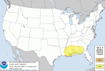
severe hazards. Given some lingering model differences, will only
introduce 15% category for this outlook, but higher probabilities
might be warranted with better model agreement in later updates.

(Day 5) - A severe threat will probably persist as this feature
continues into the TN Valley region Monday and possibly the Middle
Atlantic region Tuesday. However, model difference become more
substantial at this time frame, so will defer introduction of any
categorical risk areas to possibly the next update.

(Days 6-7) - Models including most ensemble members are in
reasonable agreement regarding the approach of an upper trough into
the Plains with robust moisture return toward the early and middle
part of next week. If these trends continue, a severe risk area may
be introduced for portions of the central and southern Plains in the
next 4-8 outlook update.

..Dial.. 10/21/2021

CLICK TO GET WUUS48 PTSD48 PRODUCT
 
Messages
2,833
Reaction score
4,557
Location
Madison, WI
While it's definitely prone to change and isn't a sure indicator, CIPS seems to be picking up on the system for next Wednesday (snapshot valid at 00Z on the 28th).
View attachment 10530

Everybody's favorite day of the week in Dixie Alley!

12Z GFS is more progressive with the first trough (doesn't cut it off over the east), depicting potential threats from the Plains eastward Sunday through the middle of next week. Sunday is in NAM range and some forecast soundings along the warm front over Missouri/west-central to southwest Illinois look pretty ominous.
 
Messages
1,056
Reaction score
1,278
Location
jackson tennessee
Special Affiliations
  1. SKYWARN® Volunteer
Everybody's favorite day of the week in Dixie Alley!

12Z GFS is more progressive with the first trough (doesn't cut it off over the east), depicting potential threats from the Plains eastward Sunday through the middle of next week. Sunday is in NAM range and some forecast soundings along the warm front over Missouri/west-central to southwest Illinois look pretty ominous.
Agree. Going over some gfs 12 z guidance. Could be looking at 30 percent area as early morning update southern plains … next week looks buisy
 

Weatherphreak

Member
Messages
352
Reaction score
346
Location
Huntsville
The yearly Halloween storm. Always seems to be a severe threat the week of Halloween followed by cooler temps. Not quite getting the colder temps though.
 

Clancy

Member
Messages
2,545
Reaction score
4,610
Location
Macland, Georgia
CIPS doesn't seem to like next Wednesday. This is the tornado probability specifically. (Sorry for the awful crop it wouldn't let me save the image and I'm on mobile )
 

Attachments

  • Screenshot_20211022-070809~2.jpg
    Screenshot_20211022-070809~2.jpg
    231.8 KB · Views: 0

TH2002

Member
Sustaining Member
Messages
3,168
Reaction score
4,808
Location
California, United States
Special Affiliations
  1. SKYWARN® Volunteer
GFS model is showing some activity for D3/Sun but pretty much saying "nothing to see here" as far as D6/Wed is concerned. Obviously there is a lot of variation in the different models to say with any certainty how things will unfold next week.
 

cincywx

Member
Messages
441
Reaction score
797
Location
Cincinnati, OH
Special Affiliations
  1. SKYWARN® Volunteer
7dca9acc3049aeb7a9159fd28e793a34.jpg


not hard to see where the tornadoes are on CC
 
Back
Top