• Welcome to TalkWeather!
    We see you lurking around TalkWeather! Take the extra step and join us today to view attachments, see less ads and maybe even join the discussion.
    CLICK TO JOIN TALKWEATHER
Logo 468x120

Archive Severe Weather 2019

Status
Not open for further replies.

Taylor Campbell

Moderator
Moderator
PerryW Project Supporter
Messages
2,102
Reaction score
2,189
Location
Wedowee, AL
Special Affiliations
  1. SKYWARN® Volunteer
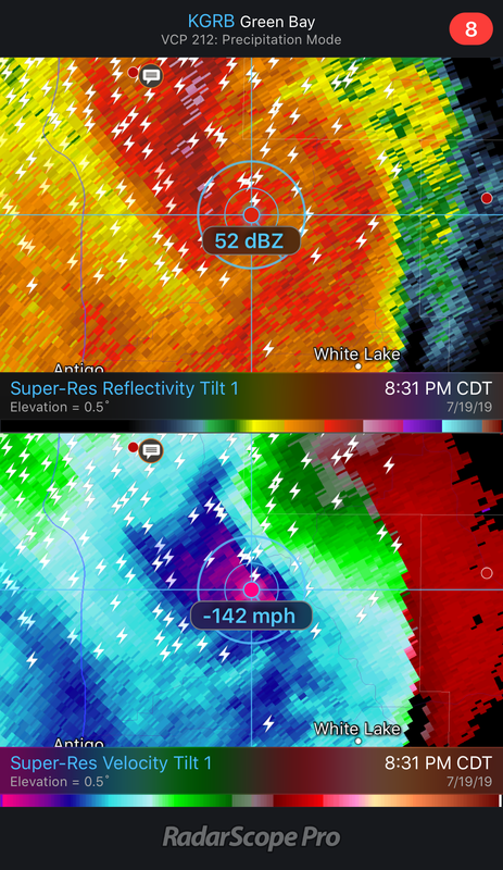
Ouch. That’s a heck of a nasty environment along that boundary. Incredible stuff going on. I could see something historic coming later.


Taylor Campbell

Moderator
Moderator
PerryW Project Supporter
Messages
2,102
Reaction score
2,189
Location
Wedowee, AL
Special Affiliations
  1. SKYWARN® Volunteer
Very mean storms near the MN/WI border right now. Funnel cloud report with storm southeast of Rush City.
 

bwalk

Member
Messages
597
Reaction score
291
Location
Prattville, Al
Dew Points along the Wisconsin River today are said to be historic and record-breaking. The map I saw showed dew points of 90, 89, and 88 (unverified at the time I viewed them) along the river. That is some massively heavy, wet air - even for us Gulf States folk.
 

Lori

Administrator
Staff member
Administrator
Moderator
Messages
1,035
Reaction score
653
Location
Vandiver, AL
Special Affiliations
  1. SKYWARN® Volunteer
Big time bowing towards the lake in Wisconsin!!B3E646BE-ECC5-45AC-9801-8F242F4C867B.png
 

Taylor Campbell

Moderator
Moderator
PerryW Project Supporter
Messages
2,102
Reaction score
2,189
Location
Wedowee, AL
Special Affiliations
  1. SKYWARN® Volunteer
This is a radar image I grabbed earlier. Pretty freaking incredible.

IMG-6860.png
 

Austin Dawg

Member
Sustaining Member
Messages
852
Reaction score
1,299
Location
Leander, Texas
Last night, National Geographic aired their new show Witness to Disaster and focused on April 11, 2011. They did a good job covering my hometown Smithville and the EF-5 that destroyed most of the town.

I took out some pictures of the town I had taken before that day and it still hurts to see where once all of those huge, old hardwood trees stood and filled the town over small houses, now there is nothing but flat earth, grass and still no homes.

It will never be the same.
 

warneagle

Member
Messages
3,730
Reaction score
3,213
Location
Arlington, VA
Special Affiliations
  1. SKYWARN® Volunteer
SPC upgraded to a 10% hatched TOR in central IL at 1630. Also added some “strong” tornado language and mentioned a potential upgrade to a TOR and/or wind-driven MDT.
 

ghost

Member
PerryW Project Supporter
Messages
1,004
Reaction score
352
Location
NW AL
Brad Travis just said there had been over 100 cloud to ground lighting strikes in the last 5 min from severe thunderstorm over Lauderdale Co. I know the wind gusts were so strong it blew the heavy thick cover off of our hot tub and carried it several feet across our backyard. I’m guessing the gust was close to 60 mph. Definitely the strongest gust from a thunderstorm I’ve seen in several years
 

ghost

Member
PerryW Project Supporter
Messages
1,004
Reaction score
352
Location
NW AL
We watched Brad Travis again at 10:00 and it sounded like he said over 400 cloud to ground strikes in Lauderdale Co. from that storm. I know it seemed like continuous thunder and lightning for about 20 min when the storm hit us, but that is an unreal number of lightning strikes. Is there a weather sensor online that measures cloud to ground strikes for storms that can confirm this number?
 

warneagle

Member
Messages
3,730
Reaction score
3,213
Location
Arlington, VA
Special Affiliations
  1. SKYWARN® Volunteer
There may be a bit of a window for some discrete supercells this evening in KS/MO. Shear profiles aren’t super impressive but not bad for August.
 
Status
Not open for further replies.
Back
Top