• Welcome to TalkWeather!
    We see you lurking around TalkWeather! Take the extra step and join us today to view attachments, see less ads and maybe even join the discussion.
    CLICK TO JOIN TALKWEATHER
Logo 468x120

Archive Severe Weather 2019

Status
Not open for further replies.

warneagle

Member
Messages
3,729
Reaction score
3,208
Location
Arlington, VA
Special Affiliations
  1. SKYWARN® Volunteer
I spotted another hail video and it was insane! Like bowling balls from the sky!
Yeah, it’s been a rough year for eastern/southeastern Europe so far. There’s been major flooding in Hungary and some parts of Romania in addition to the hail, as well as quite a few tornadoes in Romania and Ukraine.
 

Equus

Member
Messages
3,290
Reaction score
3,368
Location
Jasper, AL
Special Affiliations
  1. SKYWARN® Volunteer
Environment Canada has rated yesterday's tornado EF-1 thus far; I assume updates will be posted here
 

Equus

Member
Messages
3,290
Reaction score
3,368
Location
Jasper, AL
Special Affiliations
  1. SKYWARN® Volunteer
New Mexico has been a hotbed of activity these last couple weeks. Radar coverage isn't ideal though.
 

Kory

Member
Messages
4,928
Reaction score
2,119
Location
Tuscaloosa, Alabama
Tomorrow looks like a good set up for some low topped supercells...mainly a damaging wind threat with a secondary brief, isolated tornado threat across LA, MS, and AL.
 

Taylor Campbell

Moderator
Moderator
PerryW Project Supporter
Messages
2,102
Reaction score
2,189
Location
Wedowee, AL
Special Affiliations
  1. SKYWARN® Volunteer
Cool tornado warned storm in Louisiana right now.
 

Equus

Member
Messages
3,290
Reaction score
3,368
Location
Jasper, AL
Special Affiliations
  1. SKYWARN® Volunteer
There's a MCD out for that one storm right now. Fascinating lil cell.

Both the NAM and the HRRR are spitting out a few low end TOR soundings for tomorrow late evening indeed with both showing the surface low from the disturbance moving into northern MS backing the low level winds and allowing fairly decent deep layer shear for the time of year, which is... interesting I guess. Not even in the marginal and the NWS isn't terribly concerned but I'll still keep an eye to the sky. The only two tornadoes I've ever seen happened in June in Alabama so there's a precedent for this lol
 

Equus

Member
Messages
3,290
Reaction score
3,368
Location
Jasper, AL
Special Affiliations
  1. SKYWARN® Volunteer
Tornado-driven Slight on the Day One for southern MS. Didn't see that coming so quickly.
 

Kory

Member
Messages
4,928
Reaction score
2,119
Location
Tuscaloosa, Alabama
Ah, the classic Gulf Coast convective complex. Only hope for any severe or widespread soaking rainfall later today is if that breaks up. Otherwise, we’ll just see that light rain shield and scattered showers.
 

South AL Wx

Member
Meteorologist
Messages
309
Reaction score
311
Location
Wetumpka, AL
Special Affiliations
  1. SKYWARN® Volunteer
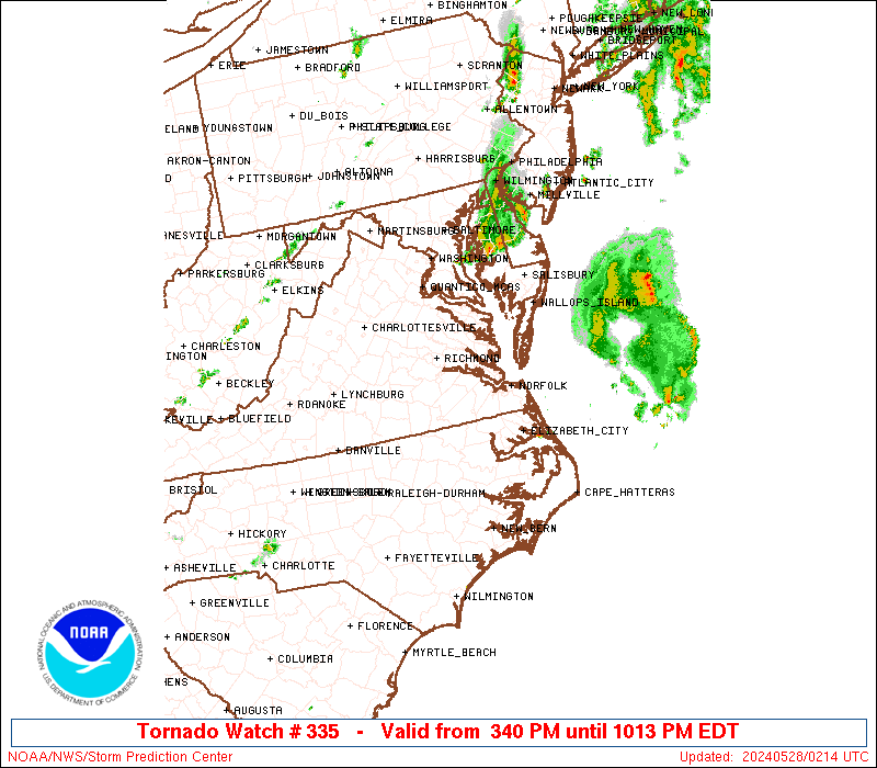
Tornado Watch just issued:

ww0335_radar_big.gif
 

Equus

Member
Messages
3,290
Reaction score
3,368
Location
Jasper, AL
Special Affiliations
  1. SKYWARN® Volunteer
We are in the 2% tor/Marginal overnight now. Also this

Mesoscale Discussion 1011
NWS Storm Prediction Center Norman OK
0806 PM CDT Thu Jun 06 2019

Areas affected...east-central MS...central AL

Concerning...Severe potential...Watch unlikely

Valid 070106Z - 070200Z

Probability of Watch Issuance...20 percent

SUMMARY...Transient supercells will be capable of intermittent
strengthening of low-level mesocyclones with the strongest updrafts.
A brief/weak tornado is possible this evening. The isolated
character and magnitude of the threat will probably preclude the
need for a small tornado watch.

DISCUSSION...Radar mosaic shows a band of convection, from
north-central MS southeastward into west-central AL, with embedded
discrete cores immediately east of a surface low over east-central
MS. Surface observations show backed southeasterly surface winds
east of the ongoing convective activity. KBMX VAD show the
low-level winds acting to enlarge the hodograph (around 200 m2/s2
0-1km SRH). The 00z Birmingham, AL raob showed a very moist/deep
boundary layer with just over 100 J/kg MLCAPE, all located below
500mb. The equilibrium level (based on a 100mb mean parcel) is just
below the -20 degrees C level and would likely not support much
lightning with the stronger updrafts. The moist-adiabatic lapse
rate/pseudo tropical profile will not cool substantially during the
evening.

As a belt of modestly strong, southerly 850mb flow shifts northward
across central and then into north-central AL and northwest GA
through the late evening, expecting episodic strengthening of small
mesocyclones in the very moist airmass over far east-central MS in
the near term and later into parts of central AL. A brief/weak
tornado may accompany the strongest circulations.

..Smith/Grams.. 06/07/2019
 

Lori

Administrator
Staff member
Administrator
Moderator
Messages
1,035
Reaction score
653
Location
Vandiver, AL
Special Affiliations
  1. SKYWARN® Volunteer

South AL Wx

Member
Meteorologist
Messages
309
Reaction score
311
Location
Wetumpka, AL
Special Affiliations
  1. SKYWARN® Volunteer
We had a severe thunderstorm move through the Montgomery area earlier. A few trees were knocked down, and KMGM recorded a wind gust of 59 mph. But the funniest part was the Chick-fil-A cow:


"I gotta go Julia, we got cows!"
 

Taylor Campbell

Moderator
Moderator
PerryW Project Supporter
Messages
2,102
Reaction score
2,189
Location
Wedowee, AL
Special Affiliations
  1. SKYWARN® Volunteer
LOL! That’s awesome! I’m golfing RTJ in Opelika, and the worst missed us. :-(
 
Status
Not open for further replies.
Back
Top