• Welcome to TalkWeather!
    We see you lurking around TalkWeather! Take the extra step and join us today to view attachments, see less ads and maybe even join the discussion.
    CLICK TO JOIN TALKWEATHER

Archive Severe Weather 2019

Status
Not open for further replies.
February 6-7 may be something to watch. I’d be interested in hearing someone who is better at reading maps opinion.

To me, it looks like a rainmaker with probably Isolated and Scattered Thunderstorms. Being that it is a week out, we know how things can change though.
 
Despite not much consistency in the models, CIPS analog guidance is picking up on next week's severe potential. From the GFS ensembles.

51391245_1012620122255881_4609781050107756544_n.jpg
 
I'm so very ready for above average temperatures, and more chances of severe weather! Today's EURO showed temperatures comfortably into the 70s across a wide portion of the Southeast early next week. It was close to the 80 degree mark in some areas of LA, MS, and AL. The GFS is warm too, and has the same idea for the places where there aren't clouds, and rain.
 
Last edited:
The Euro is multiple rounds of severe weather next week. One Monday night into Tuesday and then Wednesday afternoon and evening. Large scale troughing will be anchored to the west of the Deep South next week with several vort maxes rounding the base of the trough. We will have ample return flow as well...
 
The Euro is multiple rounds of severe weather next week. One Monday night into Tuesday and then Wednesday afternoon and evening. Large scale troughing will be anchored to the west of the Deep South next week with several vort maxes rounding the base of the trough. We will have ample return flow as well...

Yeah I was wondering about this. Does it look widespread to you at this point?
 
The Euro is multiple rounds of severe weather next week. One Monday night into Tuesday and then Wednesday afternoon and evening. Large scale troughing will be anchored to the west of the Deep South next week with several vort maxes rounding the base of the trough. We will have ample return flow as well...

Checking in from the frozen tundra here. As uncommonly cold as this Arctic push is, it's not really going to penetrate especially deep into the Gulf. The GFS shows the air mass across the western Gulf already beginning to modify by tomorrow.
 
I love the look on the Euro and GFS for next week. I'll be out at Lake Tahoe next week, and am hoping for a cold/snowy pattern. Warm here in the SE usually means a cool/snowy look out there.
Lucky guy, love me some Lake Tahoe! Have fun!
 
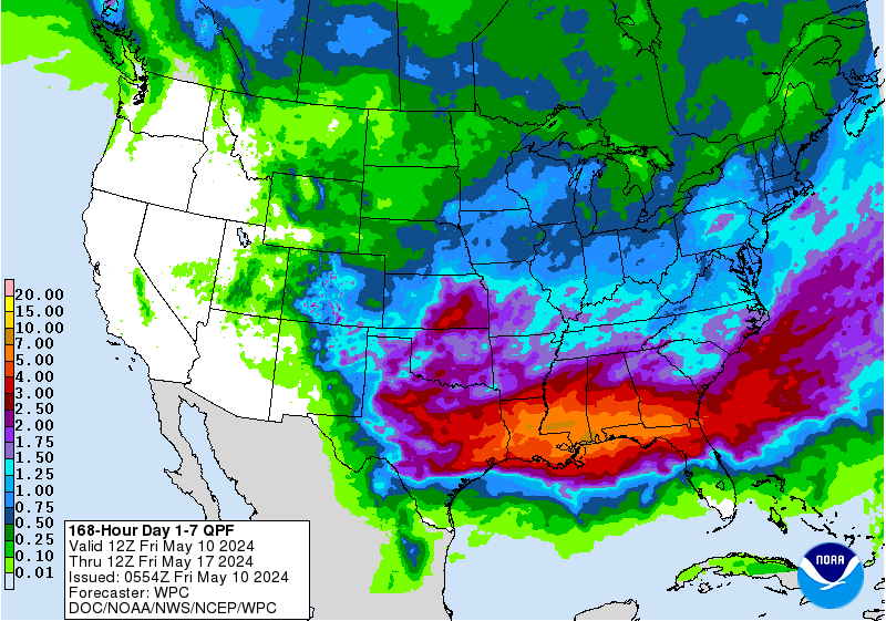
While trough amplification has become less favorable for severe wx next week....it still looks to remain stormy. Another 3-5" rain event is on the docket...

p168i.gif
 
Lucky guy, love me some Lake Tahoe! Have fun!

It'll be my third time out there, it's one of me and my wife's favorite places to go. Haven't been able to make it out during summer yet though.

At this point I'm just hoping to be able to get from Reno to the mountain on Saturday evening. They are looking at 3-5 feet of snow on the mountains from Saturday through Monday, and I'm just hoping I can catch a break in the snow to get there.
 
Next week needs to be watched ... euro trying hard to put down severe threat mid week...

Instability looks iffy at best unless the flow becomes less meridional in the mid levels at least on the Euro, there is too much WAA aloft right now via the sub tropical jet.
 
Instability looks iffy at best unless the flow becomes less meridional in the mid levels at least on the Euro, there is too much WAA aloft right now via the sub tropical jet.

Good ole sub tropical jet dominating us this El’Nino season!
 
Status
Not open for further replies.
Back
Top