
Navigation
Install the app
How to install the app on iOS
Follow along with the video below to see how to install our site as a web app on your home screen.
Note: This feature may not be available in some browsers.
More options
-
Welcome to TalkWeather! We see you lurking around TalkWeather! Take the extra step and join us today to view attachments, see less ads and maybe even join the discussion. CLICK TO JOIN TALKWEATHER
You are using an out of date browser. It may not display this or other websites correctly.
You should upgrade or use an alternative browser.
You should upgrade or use an alternative browser.
Severe Threat May 15-16, 2025
- Thread starter CheeselandSkies
- Start date
TommorowFor today,?
Ozonelayer
Member
We still think they'll issue a D2 MDT?Tommorow
Not sure, honestly it could probably be issued for the damaging wind threat alone imo. That may outshine the tornado threat in general if the 12z HRRR is rightWe still think they'll issue a D2 MDT?
Ozonelayer
Member
Fair. Honestly, if the HRRR runs leading up to the 18z show something like the 06z, then they'll probably issue a MDT for both tornadoes and damaging winds.Not sure, honestly it could probably be issued for the damaging wind threat alone imo. That may outshine the tornado threat in general if the 12z HRRR is right
Reed Timmer Extreme Meteorologist
9m ·SEVERE WEATHER OUTBREAK LIKELY TODAY WITH EF2+ TORNADOES POSSIBLE including Minneapolis to Chicago
A long duration severe weather outbreak is expected today across the Upper Midwest starting as early as midday across parts of central and northern Minnesota to the west of Minneapolis. Supercells then erupt in the deeper moisture as the jet stream advances by 4 pm in central Wisconsin, building into northern Illinois including the Chicago area by evening. These supercells will be capable of producing EF2 and stronger tornadoes. The tornado threat then shifts across northern Indiana and into southwest Lower Michigan and east during the evening and overnight.
Minneapolis to Madison to Chicago to Gary and east from there: stay tuned to severe weather watches and warnings today and tonight

AJS
Member
I knew this post from Reed was coming lol.Reed Timmer Extreme Meteorologist
9m ·
SEVERE WEATHER OUTBREAK LIKELY TODAY WITH EF2+ TORNADOES POSSIBLE including Minneapolis to Chicago
A long duration severe weather outbreak is expected today across the Upper Midwest starting as early as midday across parts of central and northern Minnesota to the west of Minneapolis. Supercells then erupt in the deeper moisture as the jet stream advances by 4 pm in central Wisconsin, building into northern Illinois including the Chicago area by evening. These supercells will be capable of producing EF2 and stronger tornadoes. The tornado threat then shifts across northern Indiana and into southwest Lower Michigan and east during the evening and overnight.
Minneapolis to Madison to Chicago to Gary and east from there: stay tuned to severe weather watches and warnings today and tonight
View attachment 41598
Eoline
Member
Hey, let's be glad he didn't say "500 tornadoes" again!I knew this post from Reed was coming lol.

My sentiment every time Reed posts.Reed Timmer Extreme Meteorologist
9m ·
SEVERE WEATHER OUTBREAK LIKELY TODAY WITH EF2+ TORNADOES POSSIBLE including Minneapolis to Chicago
A long duration severe weather outbreak is expected today across the Upper Midwest starting as early as midday across parts of central and northern Minnesota to the west of Minneapolis. Supercells then erupt in the deeper moisture as the jet stream advances by 4 pm in central Wisconsin, building into northern Illinois including the Chicago area by evening. These supercells will be capable of producing EF2 and stronger tornadoes. The tornado threat then shifts across northern Indiana and into southwest Lower Michigan and east during the evening and overnight.
Minneapolis to Madison to Chicago to Gary and east from there: stay tuned to severe weather watches and warnings today and tonight
View attachment 41598

It's Probably one of his more tamer posts lol.I knew this post from Reed was coming lol.
I’m just happy he’s not calling funnel clouds nipples and running around at truck-stops shirtless again.Hey, let's be glad he didn't say "500 tornadoes" again!
Eoline
Member
I’m just happy he’s not calling funnel clouds nipples and running around at truck-stops shirtless again.

I was wrong, not 500, but 100 is still insane. Didn't the outlined area see like... 30?

lake.effect
Member
I just saw Reed in the dominator rolling down Michigan Ave near the Water Tower. Not a good omen.
Last edited:
- Thread starter
- #335
CheeselandSkies
Member
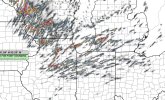
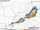
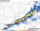
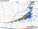
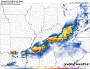
12Z CAM trend is undeniably ugly for southern Wisconsin/northern Illinois this evening. Strong agreement on a significant, dangerous event. Non a fan of how both 3K NAM and HRRR are now on the big bow echo train. RRFS remains with more spaced out cells.
(Mainly focusing on North MS)
12z HRRR at 2am Saturday
00z RRFS at 1am Saturday
12z 3km NAM at 3am Saturday
06z RRFS at 1am Saturday
Honestly, pretty good consensus on timing. Both 00z and 6z RRFS have another MCS rolling across North MS by 11pm Saturday or by midnight Sunday.
It wouldn't surprise me to see that Enhanced Risk brought further south (but probably not as far south as Jackson, MS) with 5% TOR, 30% SIG damaging wind probability, and 30% SIG Hail. Again, overall storm mode dependent upon tornado threat. Could I see a SIG TOR hatch for North MS? Yes, I could.
Also, while widespread damaging winds are the primary threat for MCS/Derechoes, they do produce large hail and tornadoes.
Attachments
DanLarsen34
Member
In his defense, March 15th absolutely had the potential to produce 50-100 tornadoes, especially if the model runs from the day before were anywhere close to what actually happened. I think the consensus in here the day prior to the event was that the 15th had the potential to be the most significant, high-end event we had seen in Dixie since April 27, 2011.View attachment 41605
I was wrong, not 500, but 100 is still insane. Didn't the outlined area see like... 30?
Fortunately, we had some mitigating factors come together that ultimately tamped things down to a more traditional Dixie event.
Eoline
Member
That's fair. But hypecasting can also be dangerous, it's like telling well over a million people to shelter from like twenty tornadoes. That's also just one example, he does that all the time (March 15 isn't the best example).In his defense, March 15th absolutely had the potential to produce 50-100 tornadoes, especially if the model runs from the day before were anywhere close to what actually happened. I think the consensus in here the day prior to the event was that the 15th had the potential to be the most significant, high-end event we had seen in Dixie since April 27, 2011.
Fortunately, we had some mitigating factors come together that ultimately tamped things down to a more traditional Dixie event.
Last edited:
notsoencrypted
Member
I have nothing useful to add, but I am watching with y'all, and thinking once again that I need to get a drone and a certificate so I can be at home in case of having to get the pets to shelter but also be able to get photos without trees in the way. 
Cyclonic Paracosm
Member
def remember, for 4/2, models had a very linuar mode and spc outright said, "ya no thats a whole lotta bull"